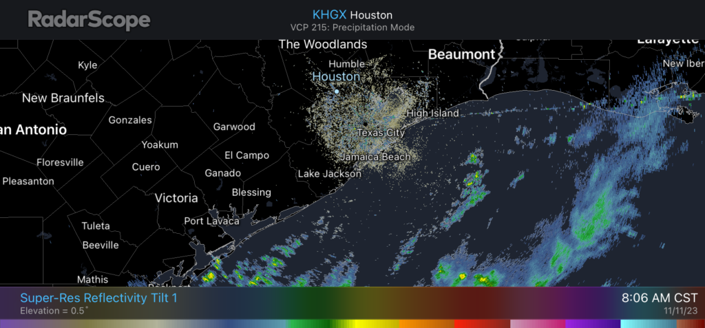
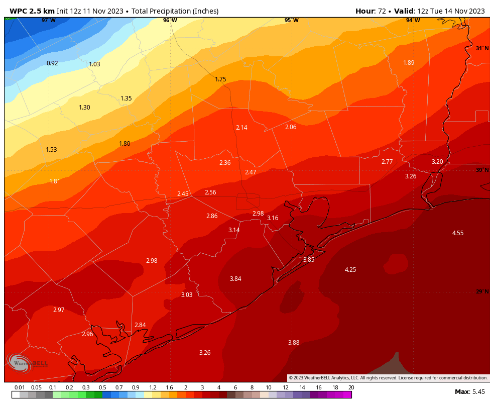
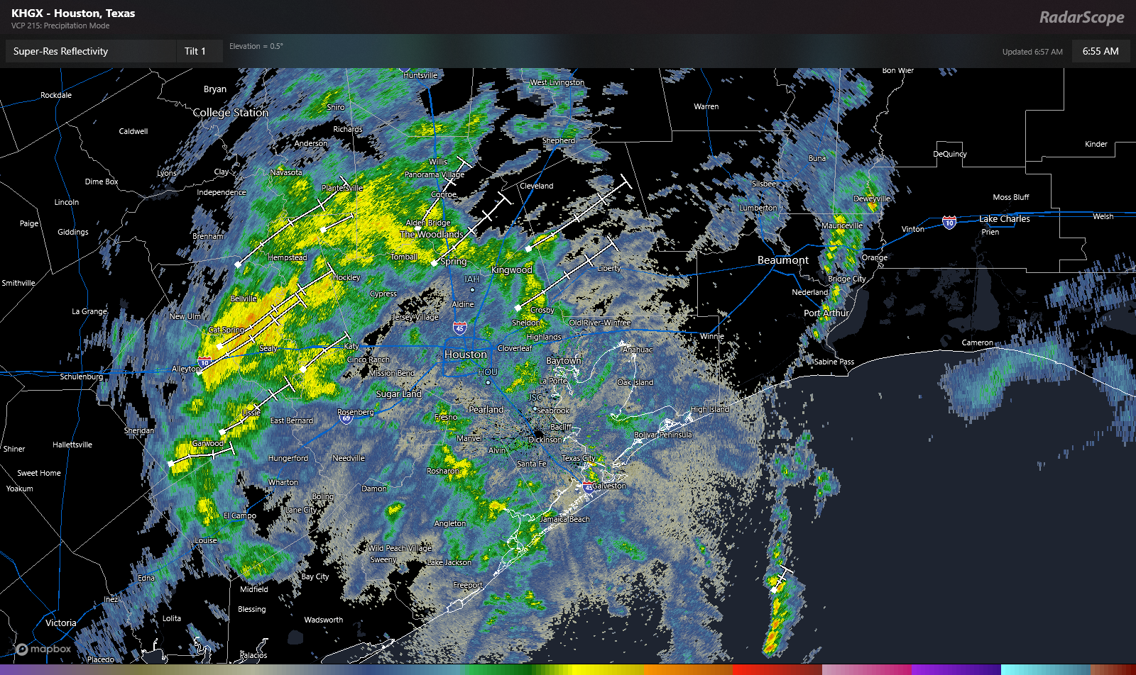
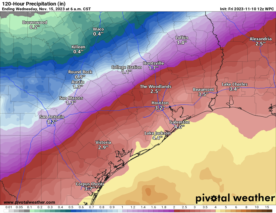
Not everyone will see it, but Houston faces the threat of heavy rainfall today. We’re upgrading to a Stage 2 flood alert

If you live south of Interstate 10, you may be wondering what all the fuss is about in terms of the potential for heavy rainfall this week. Much of the southern half of Houston did not see any rainfall Monday, whereas some locations near Tomball received as much as 4 inches of rainfall in a short period of time. This is a pattern we expect to continue today. Not everyone is going to see heavy rainfall, but the areas that do likely will see high rainfall rates that can quickly back up streets.

For today and tonight I expect that most of the area will receive 1 to 2 inches of rainfall, which is more than manageable. What concerns me is that the atmosphere is primed for heavy rainfall, and some locations within the Houston metro area may quickly pick up 4 to 6 inches through this evening, and this may cause more than nuisance street flooding. For this reason we are upgrading to a Stage 2 flood event for today. Please understand that most of the Houston region likely will not see serious flooding, but the potential exists and you need to be weather aware today and tomorrow.

Tuesday

This storm activity will be driven by a combination of a very moist atmosphere as well as upper-level disturbance over southern Texas that will produce the kind of lift needed for heavy rainfall. Storms have already developed near Victoria and Port Lavaca this morning, and they should steadily build toward the Houston metro area from the southwest. By mid-morning these storms should move into the central Houston area. The greatest threat appears to be from mid-morning to mid-afternoon for Houston.

Highs, otherwise, will reach about 80 degrees in the metro area with cloudy skies. Winds will be out of the south at 5 to 10 mph. Rain chances will probably slacken this evening and into the overnight hours. Lows will drop to around 70 degrees in the city tonight, with slightly cooler conditions inland.

Excessive rainfall outlook for Tuesday and Tuesday night. (NOAA)

Wednesday

This will be another day with the potential for heavy rainfall and widespread showers, with perhaps an earlier start during the morning hours than on Tuesday. This may be a repeat of Tuesday in terms of a flooding threat, or not quite as bad. In any case, we’ll be watching things closely and publish an update this evening if warranted. Highs should again reach about 80 degrees, with light southeasterly winds. Lows should drop into the low 70s.

Thursday and Friday

As the aforementioned upper-level low pressure system starts to lift away from the Houston area, the threat of heavy rainfall should start to ease somewhat. That’s not to say rain chances will be zero, as they’ll still be in the 30 to 50 percent range each day. Both afternoons may see a bit of sunshine, allowing highs to reach the mid-80s. Lows remain warm and sticky.

Saturday and Sunday

So the weekend does not look ideal for outdoor activities. Saturday, in particular, should be cloudy with a healthy chance of light to moderate rainfall. I’m not concerned about flooding, but we may see some thunderstorms. Highs likely will be in the mid-80s. Sunday has a chance to be more favorable for outdoor activities, with lower rain chances and the possibility for partly sunny skies. Rain chances are still going to be at least decent, however, for some sprinkles or showers.

Houston will warm up through the week, before the possibility of a weak front by next Tuesday or so. (Weather Bell)

Next week

Modest rain chances likely will continue into next week as some sort of front—not a very strong one, alas—works its way toward the region. This may give us a few days with somewhat sunny skies and slightly drier air by Tuesday or Wednesday of next week. But that forecast, for now, is a mix of data and hope on my part. We’ll see.

Stormy weather likely this week in Houston, and we’re issuing a Stage 1 flood alert

Good morning. I am sorry to say that Sunday’s forecast was a “miss” for us, in that we did not anticipate such widespread rain, nor so many thunderstorms. Candidly, I woke up and looked at the radar on Sunday morning, and upon seeing a mass of showers to the southwest of Houston said to myself, “What is that?!?” The showers also kept a lid on temperatures—with a high of just 79 degrees at Bush Intercontinental Airport. Anyway, I believe it is important to be honest with our readers.

Sunday’s wet weather heralded a much wetter pattern for the week ahead. Most of the area should see 3 to 6 inches of rain between now and next Monday, and we’ll be on the lookout for the possibility of street flooding amid stronger storms. For this reason we are issuing a Stage 1 flood alert, beginning at noon today.

The overall pattern, in absence of high pressure, will be driven by a moist atmosphere with a series of passing atmospheric disturbances. As a result we’ll see on and off showers and thunderstorms for much of this week, and possibly through the weekend. This is the kind of situation during which you’ll need to be paying attention to conditions, as these storms may well pop up during after-school activities or the evening commute.

Monday

Conditions this morning should be fairly calm, with mostly cloudy skies and warm temperatures. However, along with daytime heating, I expect to see fairly widespread showers and thunderstorms pop up this afternoon. It is possible that we see some fairly strong thunderstorms this afternoon, from about noon to 6 pm across the metro-area, so be weather aware. Any storms that develop should weaken during the evening hours. Otherwise, expect mostly cloudy skies with high temperatures in the mid-80s, and southerly winds. Lows will only drop into the low-70s.

Tuesday

A similar day, with muggy air and a chance of fairly widespread showers and thunderstorms during primarily the afternoon hours. Not everyone will see rainfall, but much of the region will, and some of these thunderstorms could be quite strong. Again, this activity should wind down during the evening hours. Highs on Tuesday should again be roughly in the mid-80s, with southerly or southwesterly winds.

Wednesday and Thursday

Both of these days should see partly to mostly cloudy skies, with perhaps a 50 percent chance of rain. However, for now I think the chance of strong thunderstorms is lower. Highs will probably fall somewhere in the mid-80s, with muggy air.

This ensemble mean rain forecast from the European model is far from a certainty, but it gives you a sense of the potential for heavy rainfall this week in Texas. (Weather Bell)

Friday, Saturday, and Sunday

Atmospheric moisture levels will surge this weekend, which could set the stage for even more widespread rainfall. However, whether this transpires will depend on the upper-level atmosphere and whether we see a robust low pressure system drop down toward Texas. So for now the weekend forecast ranges from somewhat wet—scattered, on and off showers—to downright wet with fairly widespread showers and the threat of heavy rainfall. I don’t have enough confidence to make the call yet, but I do know the air is going to be muggy, and we should see highs in the mid- to possibly upper-80s—the warmer temperatures would come in the scenario with less rainfall.

Next week

After the potential for more rainfall on Monday, most modeling suggests rain chances will die down somewhat for next week. It’s possible that some sort of weak front pushes through in about 8 to 10 days, but that’s not something I’m going to bet the farm on.

Temperatures reached the low 60s this morning. Sorry to say, that ain’t happening again for awhile.

The temperature this morning has fallen to 63 degrees at Bush Intercontinental Airport, and I can’t help but wonder when we’ll see temperatures below 65 degrees in Houston again. Maybe in about 10 days, or maybe not until September? In any case, a much warmer and more humid pattern is coming with high temperatures near or above 90 degrees for the next week after today.

Thursday

As high pressure slides away it will be replaced by a more pronounced onshore flow and a more unstable atmosphere. For today, that means partly sunny skies, with high temperatures in the mid-80s. Winds will be out of the south at 10 mph, with gusts up to 20 mph later this afternoon. There will be a chance of scattered showers and thunderstorms in Houston tonight, but the bigger threat for severe weather is well to the west of the metro area over central Texas and into the Brazos Valley. Overall rain chances in Houston tonight are probably 20 percent or so. Lows will only drop into the low-70s.

Severe weather outlook for Thursday and Thursday night. (NOAA)

Friday

A slight chance of showers and thunderstorms will persist on Friday, but for the most part we’re looking at mostly cloudy skies and warm, humid weather. Expect high temperatures to reach about 90 degrees, with southerly winds. This day will really feel like “early summer” in Houston, and the sticky conditions will stick around for awhile. Lows Friday night only drop into the mid-70s.

Saturday and Sunday

Expect more of the same this weekend. If you’re looking for sunshine this weekend, the middle of the day on Saturday is probably your best bet, when skies may become partly sunny for several hours. Otherwise, clouds will be more common than clear skies. Isolated showers are possible on both days along with the sea breeze, but I would peg their chances at only about 10 or 20 percent each day. Highs will be around 90 degrees, or in the low 90s, for both weekend days. Are y’all ready to sweat?

Saturday certainly looks toasty in Houston. (Weather Bell)

Next week

Next week will not yield much change in our weather, at least not right away. Look for high temperatures in the upper 80s to 90 degrees most days, with lows in the mid-70s. Rain chances are going to start out at 20 percent or so, but could increase significantly by the latter part of the week in response to changes in the upper atmosphere. But my confidence in that portion of the forecast is low. Just know that heat and humidity are going to be your best and constant friend for awhile.

A message from our sponsor, Reliant

As Eric has covered this week, it’s been a glorious spring in Houston, but summer is right on its heels, with rising temperatures expected in the coming days. As a longtime supporter of Eric and Matt’s no-hype approach, Reliant wants all Houstonians to feel prepared and informed on how to save money and energy during the summer heat. Check out our energy efficiency tips below:

  • Follow the four-by-four principle. During the summer months, setting your thermostat four degrees higher when you’re away from home for more than four hours can help reduce electricity usage and costs. When your thermostat is set below 78°F, each degree cooler can increase your costs by up to seven percent. While the suggested temperature for ideal energy use in the summer is 78°, we know a comfortable temperature setting is a personal preference. No matter your preferred setting, the 4×4 principle will help you reduce your usage and ultimately save on your electricity bill.
  • Schedule an HVAC checkup. Now is the time to schedule a tune-up with an HVAC service professional to ensure your system is running at its best. Just as you wouldn’t take your car out for a long road trip without getting serviced, you don’t want to operate your A/C system during the long, hot summer without proper maintenance. Schedule a multi-point checkup to ensure your system is running at its best.
  • Reduce the temperature on your electric water heater to 120°F. You could save three to five percent in energy costs per year.
  • Check air filters monthly and replace as necessary. A clean air filter can keep your A/C running at peak condition.
  • Avoid using heat-producing appliances like the clothes dryer, dishwasher, or oven during the hottest times of day. These appliances can cause your A/C to work harder to keep your home cool.
  • Install a programmable thermostat, like a Nest, and you can save an estimated 10 percent a year on cooling and heating costs. You can schedule it to only run when you’re home, so you don’t waste energy cooling an empty space. And, the Nest also learns your schedule, can sense when you’re away and automatically adjusts the temperature to help you conserve
  • Use blinds or curtains during the summer to reduce solar heat gain. Sunlight can increase the demand on your air conditioner by as much as 30 percent.

Find additional energy efficiency tips by clicking here.

Today is the last day for dewpoints in the 50s for quite awhile, maybe even months

Some people don’t like to talk about dewpoints because they’re confusing. But they’re a really helpful way to quickly assess how stick the air will feel. The scientific definition of a dewpoint is the temperature to which the air must be cooled to achieve a relative humidity of 100 percent. So if the air temperature is 70 degrees—which may sound comfortable—and the dewpoint is also 70 degrees it’s going to feel really sticky outside. But you don’t have to remember that definition for dewpoints, just this handy guide:

Dewpoints in the mid-50s or below: The air is dry and comfortable

Dewpoints in the mid-60s: The air starts feels somewhat sticky during the day, and somewhat muggy in the evenings

Dewpoints in the mid-70s or higher: Oh my god I’m dying.

I am sorry to say that today, specifically the period from around noon to late afternoon, is going to be our last shot of dewpoints in the 50s for awhile. After today we’re looking at dewpoints in the upper 60s to lower 70s for the foreseeable future. While we may get a front to knock them back in 10 or more days, it is by no means a certainty. Welcome to May.

Dew point forecast for late this afternoon in the Houston region. (Weather Bell)

Wednesday

After some fog and clouds this morning, skies are going to clear out and leave us with a mostly sunny day. This, combined with the slightly drier air mentioned above is going to allow temperatures to pop up into the mid- to upper-80s. Winds will be slight, at 5 to 10 mph, generally from the southeast. Some clouds return tonight, but lows should drop into the mid-60s for all but coast areas. This probably will be our last night in the 60s for quite a while.

Thursday

As high pressure moves off, the region will open up to a more pronounced flow off the Gulf of Mexico. This will result in more humidity and clouds, to go along with high temperatures in the mid- to upper-80s. With increased moisture the region may see some scattered showers and thunderstorms on Thursday evening and overnight. The most likely areas for this will be north and west of the metro area, in places such as College Station and Conroe. I would not expect anything particularly severe. Lows on Thursday night will only drop into the 70s.

Maybe find some water this weekend. (Weather Bell)

Friday, Saturday, and Sunday

This three day period will be hot and humid. Look for partly to mostly cloudy skies each day, with daytime highs around 90 degrees or slightly above. Rain chances are not zero, and there will probably be a few isolated showers each day. But if you’re planning outdoor activities things should be fine as long as you have plan for some temporary shelter. Which to be clear, probably won’t be needed. In addition to hot days, nights will be warm and sticky, with lows only dropping into the mid-70s.

Next week

The overall pattern does not change much next week. Daytime temperatures may drop a degree or two, but the humidity should remain more or less the same. Some better rain chances may pop up by the middle or end of next week. We’ll see.