After this morning, Houston has two more somewhat cool nights—with lows in the 60s and not oppressively high dewpoints—before things begin to warm up toward the weekend. By Friday morning we’re going to see lows only in the 70s with more humidity and well, that’s a fairly typical pattern for summer-time weather. So let’s talk about summer, which typically lasts about five months in Houston.
By strict definition “meteorological” summer runs from June through August, and “solstice” summer runs from June 21 through September 22 this year. For me, Houston’s summer typically runs from about mid-May through mid-October. Here are the four phases:
- Early summer: When we first start to see 90-degree temperatures with some regularity, but some nights in the 60s are still possible, and there’s still the thinnest hope of a weak front
- Mid summer: When highs run from 90 to 95 degrees, and nights are sultry, but you know it could still get worse
- High summer: Somewhere between late July and early September there’s a period where temperatures reach the upper 90s to low 100s and you realize, “Ok, this really is the worst.”
- Late summer: This is the period in September and early October when days grow shorter and we usually see the first front or two of the season. But most of the time it’s still hot.
We’re going to reach early summer this weekend, when we probably will see a handful of 90-degree days.
Tuesday
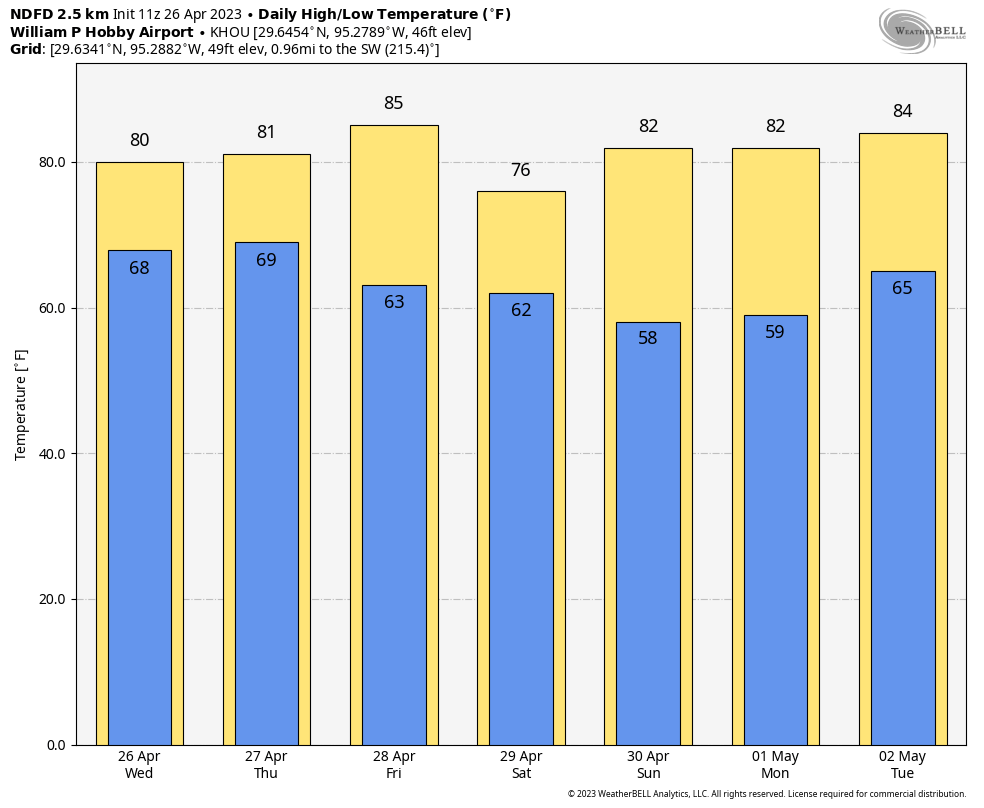
Today will be the last of three days with temperatures in the low- to mid-80s. High pressure will help to maintain an easterly flow, so we’re going to see a mix of sunshine and clouds, with clouds likely becoming more predominant later this afternoon. Winds will be light, out of the east. Low temperatures tonight will drop into the mid-60s in Houston, with cooler conditions further inland.
Wednesday
Temperatures on Wednesday will reach the mid-80s, and we’re going to see a fair bit of sunshine. For a few hours on Wednesday afternoon we should actually see dewpoints drop into the 50s, which is going to be our last smidgeon of dry air for awhile. So maybe step outside and enjoy that last bit of light humidity. Because you know what’s coming, right? Winds will be light, and overnight lows will again drop into the mid-60s.
Thursday
We’ll see one more day with temperatures in the mid-80s, but with more clouds than Wednesday. Winds will also be more pronounced out of the south, gusting to 20 mph or even a bit higher. This, my friends, is the full-on return of the onshore flow from the Gulf of Mexico. As a result, lows on Thursday night will only drop into the low 70s. There is a slight chance of light showers on Thursday night.
Friday
Despite mostly cloudy skies, we’re going to see warm and humid weather on Friday, with highs near 90 degrees. Rain chances are about 20 percent.
Saturday and Sunday
Expect more of the same this weekend, with partly to mostly cloudy skies and high temperatures of around 90 degrees. Given the moisture and a bit of instability to work with, we could see some scattered showers or possibly even a thunderstorm each day. But overall chances are probably only on the order of 20 percent. If you have plans, we’ll try to refine this forecast in the days ahead.
Next week
Temperatures back off a bit next week, maybe. Rain chances perhaps will go up. I’d ballpark chances at 20 to 40 percent each day, but my overall confidence is low. The humidity looks to stick around. The models are hinting at a chance for a weak front in 10 to 14 days, but that is far enough in the future that I’d probably not even be writing that in pencil yet. Settle in, y’all. Summer is at the gates.