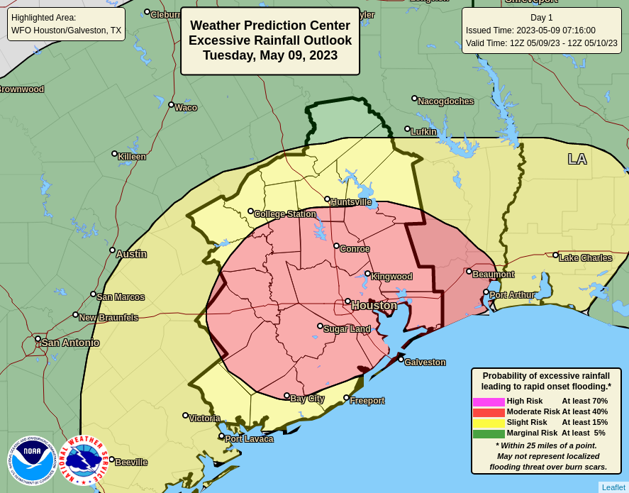
Cold and gray for two more days before sunny weather is on the way

Mostly light rains are falling across the Houston region this morning, with accumulations of around one-half an inch for most of the area overnight. These rains are exiting the area to the east, and should be mostly gone by noon. After this we’ll have a few more chilly days and nights before transitioning to a warmer pattern this weekend. And the sunshine! It’s coming back tomorrow, and will be on full display this weekend. It will make a nice change from the gray.

High temperature forecast for Thursday. Will this be the region’s coldest day until at least next December? Probably. (Weather Bell)

Thursday

Rains will depart as high pressure moves into the region today. However, as clouds will linger, it’s still going to be a cold day. Expect highs only in the low 40s, with blustery northerly winds that will gust up to about 25 mph adding to the “frigid feelings” party. Fortunately the already slackening rains will end altogether late this morning or during the early afternoon hours. Given today’s highs, it would not surprise me if this is the coldest daytime of 2023 until at least December. So if you’re more of a warm weather person—and I’ve been complained to by enough people about the cold to know that there are a lot of you out there—take some solace in that. Lows tonight will probably drop into the upper 30s.

Friday

Some clouds will remain Friday morning, but we’ll see clearing skies, with plenty of sunshine during the afternoon hours. This will help push high temperatures into the mid- to upper-50s. You’ll still feel those northerly winds at 10 to 15 mph, but they won’t be as brisk as Thursday and Thursday night. Overnight lows Friday, with clear skies, should be the coldest of the week due to efficient cooling and a lack of clouds to insulate surface temperatures. The central Houston area will see lows in the mid-30s, with inland areas seeing colder temperatures and few areas a light freeze far from the coast.

Friday night’s lows will be pretty darn low. (Weather Bell)

Saturday

This will be a mostly sunny day with highs of around 60 degrees. Moderate winds will shift to come from the southeast, which will mark the beginning of an onshore flow. As a result, lows on Saturday night will be about 10 degrees warmer than Friday night.

Sunday

Expect more sunny weather, with highs reaching about 70 degrees. Winds will again be light. This day will be another winner for those planning outdoor activities this weekend.

Next week

Some clouds will start to return Monday, with continued warming conditions. The first couple days of next week will likely bring highs in the mid-70s with a bit muggier air. And after that? Well, I am sorry to say there is no lot of concurrence in the models we look at for such forecasts. At some point, perhaps on Tuesday night or Wednesday, a front is going to push into the region. It will elevate rain chances, and perhaps bring a few thunderstorms. It’s difficult to say. This probably will knock highs down in the 60s, and lows into the 40s, for the second half of next week. But the details for this forecast will have to come at a later date. For now, bundle up!

February is starting out rather cold in Houston. What about the rest of the month?

February is coming in with a chill, as highs today may only top out in the low 40s. And conditions will be cold for the rest of the week, with a light freeze possible for inland areas on Friday night. But what does the rest of the month look like after that? We should see a return to warmer temperatures next week. And then, the second half of the month looks slightly warmer than normal. After this week it would not surprise me if the Houston region is done with freezing weather for the 2022-2023 winter. Of course that is not an official prediction yet, just a guess.

Temperature outlook for the month of February. (NOAA)

Wednesday

Today, alas, will feel like the depths of winter. Fortunately, however, temperatures across the metro area this morning are remaining in the upper 30s to about 40 degrees. I say this because some areas are seeing a light rain, instead of a freezing rain. Central and Northern Texas remain in the grip of an ice storm, and travel west of Columbus on Interstate 10, and north of Huntsville, is not advised today or tonight. There are many reports of icing in Austin, Dallas, Fort Worth, and other areas of Texas. It is a mess.

Back in the Houston area, light to moderate showers will be possible today and tonight ahead of a front that will finally shove this low pressure system away and clear our skies. Overall accumulations today, tonight, and into Thursday probably will be on the order of 0.25 to 0.75 inch, so this will be more of a nuisance rain rather than something that prompts a flooding concern. But the wetness will just add to the misery of gray skies and chilly winds. Don’t expect highs today to rise above the low 40s, and overnight lows will drop into the upper 30s.

Thursday

Some additional light showers will be possible on Thursday morning before the rains end during the afternoon. Skies will remain gray for awhile, however, so highs Thursday probably will only reach the mid-40s. Thursday night will be fairly unpleasant as northerly winds kick up in the wake of the front, and gust up to 25 mph. So yeah, don’t make any outdoor plans for Thursday night. Lows drop to around 40 degrees.

Friday

Skies will finally start to clear on Friday morning, with sunshine prevailing during the afternoon hours. Winds will be out of the north, but less blustery than Thursday night. Highs should reach the upper 50s. With lesser winds and clear skies, lows on Friday night will bottom out. A light freeze will be possible in Montgomery County, but I think most of the rest of the metro area will remain at least a few degrees above freezing.

Low temperature forecast for Friday night. (Weather Bell)

Saturday and Sunday

I still expect mostly sunny to fully sunny skies this weekend. Highs on Saturday will reach about 60 degrees, and overnight temperatures will be 5 to 10 degrees warmer than Friday night as the flow turns more southerly. Sunday will be warmer, with highs of around 70 degrees. This will be a welcome balm for those who don’t like the cold.

Next week

The early part of next week looks warmer, with partly to mostly cloudy skies and highs in the mid-70s. Some sort of rain chances return by Tuesday or Wednesday, but it’s not clear to what extent the next front will march all the way into Houston. So for now, I’m putting a big to-be-determined on our weather from Wednesday onward.

Very cold conditions in Houston, with ice just to our west and north

Good morning. Houston’s chilly and gray weather will continue for several more days. For the most part the cold and wet conditions will be mostly a nuisance, but we do have some concerns about the potential for icing in far north and west parts of the Houston metro area. Some sunshine will finally return to the region on Friday, with mostly clear skies prevailing through the weekend. Soak it up!

Issue with email newsletter

Some readers have reported problems receiving our daily email newsletter, which delivers our posts directly to your inbox. This has been going on since Sunday, and I appreciate everyone who took the time to let us know about the issue. Rest assured, we’re working to fix it, and I hope to have the service restored in a few days. In the meantime, you can always check the site after 7 am each morning for our daily post, download the Space City Weather app, or find us on our social media channels.

Tuesday

Coastal areas are seeing some patchy sea fog this morning, and this may persist over the seas until mid-morning. Lows have dropped into the upper 30s in Houston, and we’re only going to warm into the mid-40s today beneath cloudy skies. North winds, gusting to 15 or 20 mph, will not help it feel any warmer. Light, scattered showers will be possible today and tonight, but any accumulations will be slight. Lows overnight will drop into the mid- to upper-30s in the Houston metro area.

Hazardous conditions may be found on roads west and north of Houston. (National Weather Service)

As you drive west and north of Houston, particularly past Katy, Waller, and Huntsville, icing may start to become a concern on elevated roads and bridges tonight. Those concerns will become more acute to the west of Columbus and northwest of College Station where conditions will be colder. A major winter icing event is presently unfolding in Central Texas, particularly along the I-35 corridor in places such as Austin and the Dallas-Fort Worth area. These conditions may persist through Wednesday night for Central Texas, and travel should be avoided if at all possible.

Wednesday

Highs on Wednesday may only reach about 40 degrees in Houston, with continued gray skies. Showers will start to become more numerous on Wednesday afternoon and overnight in the Houston region, but again I’m not expecting too much in the way of heavy rainfall. This is good because our soils are already pretty wet, and cold grounds do not absorb much moisture. Any rain that falls will run off, and a few low-lying streets may flood, but I don’t anticipate serious disruptions from these mid-week showers. Lows on Wednesday night may actually be a few degrees warmer than Wednesday night, in the low 40s.

Thursday

Expect more gray skies and rain chances, but these should end later in the day as a cold front moves into the area and drives low pressure away. Overall accumulations for precipitation this week likely will be on the order of 0.25 to 1 inch, with a slight risk of 1 to 2 inches for areas north of Interstate 10. Highs Thursday will be somewhere in the mid-40s, with lows dropping to around 40 degrees Thursday night.
NOAA rain accumulation forecast for now through Friday. (Weather Bell)

Friday

Some sunshine, finally. Skies should clear out on Friday morning, helping to push highs in the mid-50s. Lows Friday night will drop into the upper 30s in Houston, with a few inland areas possibly seeing a light freeze.

Low temperature forecast for Saturday morning in Houston. (Weather Bell)

Saturday and Sunday

Both days should see partly to mostly sunny conditions, with highs Saturday of around 60 degrees, and perhaps the upper 60s on Sunday as the onshore flow gets going.

Next week

It looks like a warming trend will continue into about Tuesday, when some rain showers will be possible ahead of the next front. At this point, these rains look mostly light. We’ll just have to wait and see.

Houston’s weather is turning colder, and it is doing so faster than expected

This has been a weird winter for Texas in general, and Houston in particular. Normally, during a La Niña winter, we see warmer and drier than normal conditions. We have checked the box for warmth—December was about 2 degrees above normal, and January is going to wind up about 5 degrees above normal. But as for rainfall, this winter has been anything but normal. Some areas of Houston have exceeded their normal allotment of rain for December, January, and February just during the last 10 days.

Those 10-day rain totals are recapped below, and occurred courtesy of cold fronts tapping into deep Gulf moisture after warm spells. This accumulated rainfall brought some bayous and waterways in northwest Houston to near bankfull on Sunday. Although we are going to remain in a wet period through Thursday, I do not think we’ll see enough heavy rainfall to cause the overall situation to change. That is to say, our soils will remain waterlogged, but I don’t anticipate any widespread flooding. Some clearing will finally come Thursday night.

Rain accumulation during the 10 days preceding Sunday night. Some areas received nearly a foot of rainfall. (Harris County Office of Emergency Management)

Cold and Ice in Central and Northern Texas

The other big story this morning is the cold. If you’ll recall last week we waffled a lot on whether a front was going to push all the way into Houston. Well, this shallow Arctic front made it it all the way to the coast, and as a result we’re going to be cold all week, with highs generally in the 40s to 50s, and lows in the 40s. This is much colder than we anticipated even a couple of days ago. That is the end of the story for Houston, but for areas just to our north and west there is a rather nasty ice storm unfolding.

In areas such as Burleson, Brazos and Washington counties a light glaze of ice is possible on the roads today and tonight. Further away from the coast in Texas, significant icing is expected in places such as Austin and Dallas, from now through the middle of the day on Wednesday. This will seriously impact travel to and around those areas, and may cause serious power outages as ice accumulates on power lines. Areas that fall under this winter storm warning are shown in pink in the map below.

Winter storm warnings in Texas as of Monday morning. (Pivotal Weather)

Monday

Back in Houston, we are going to see a chilly, gray day with scattered (mostly light) showers today as the cold air mass moves into Houston. Temperatures later today will range from the upper 40s for inland areas to lower 50s close to the coast. No travel issues are anticipated in the Houston metro area from the scattered precipitation, but it will be cold, with a northerly wind at about 10 mph. Low temperatures tonight drop to the low 40s in Houston, with upper 30s possible for inland areas.

Tuesday

This will be another cold and gray day with high temperatures generally in the upper 40s. We will again see decent rain chances, about 40 percent, with mostly light to moderate showers. Lows will drop to around 40 degrees on Tuesday night, with blustery northerly winds at 10 to 15 mph, and higher gusts.

Wednesday and Thursday

The atmosphere will become more perturbed by the middle of the week, with a few disturbances moving through ahead of another cold front. The bottom line is that these, too, will be cold and gray days with high temperatures of about 50 degrees, and lows in the 40s. However, rain chances will be better, especially during the Wednesday night period. Although I don’t expect flooding issues to occur, areas north of Interstate 10 may pick up an additional 1 to 2 inches of rainfall through Thursday of this week, with 0.5 to 1.5 inches for areas south of the freeway. Rain chances should finally start to ebb by Thursday afternoon as the next front moves through to clear us out.

NOAA rain accumulation forecast for now through Thursday night. (Weather Bell)

Friday

Behold, the Sun does exist! We’ll see it on Friday, with mostly sunny skies and high temperatures in the upper 50s. However these clearing skies will also allow for colder temperatures on Friday night. Lows will drop into the 30s, probably, with the potential for a light freeze for inland areas. We’ll see.

Saturday, Sunday, and beyond

This weekend looks to see mostly sunny skies, with highs in the 60s. Yes, my friends, a sunny weekend. It should be something. We’ll be on the start of a warming trend by Sunday, with highs climbing into the low 70s by the early part of next week.