Good morning. In today’s post we’re going to discuss the four warmish days Houston will experience before a significant cooldown on Friday that will bring us much colder, fall-like weather for awhile. For those who have been pining away for a sustained stretch of sweater-and-hot-chocolate weather, your time is at hand.
This morning Matt and I also want to announce the opening of our annual fundraiser. Every November, for three weeks, we sell t-shirts, baseball caps, umbrellas, and more—as well as accepting donations only—to support the operation of the site. Your purchases and donations help pay for our server costs, fund the continued development of our weather app, and compensate everyone here at Space City Weather for our time. Every word we write is free, for all, thanks to your generous support.
This year we’re offering three different t-shirts and sweatshirts, as well as other merchandise. It all can found here on our 2022 fundraiser page. These items include:
- Squashing hype t-shirt
- Four seasons of Houston t-shirt
- Caricature of Matt and Eric t-shirt
- Space City Weather trucker hat
- Golf umbrella
- 22 oz. Tumbler
You may also simply donate funds by going to any product page, clicking “buy/donate,” and then ticking the “donate only” box. Thank you so much!

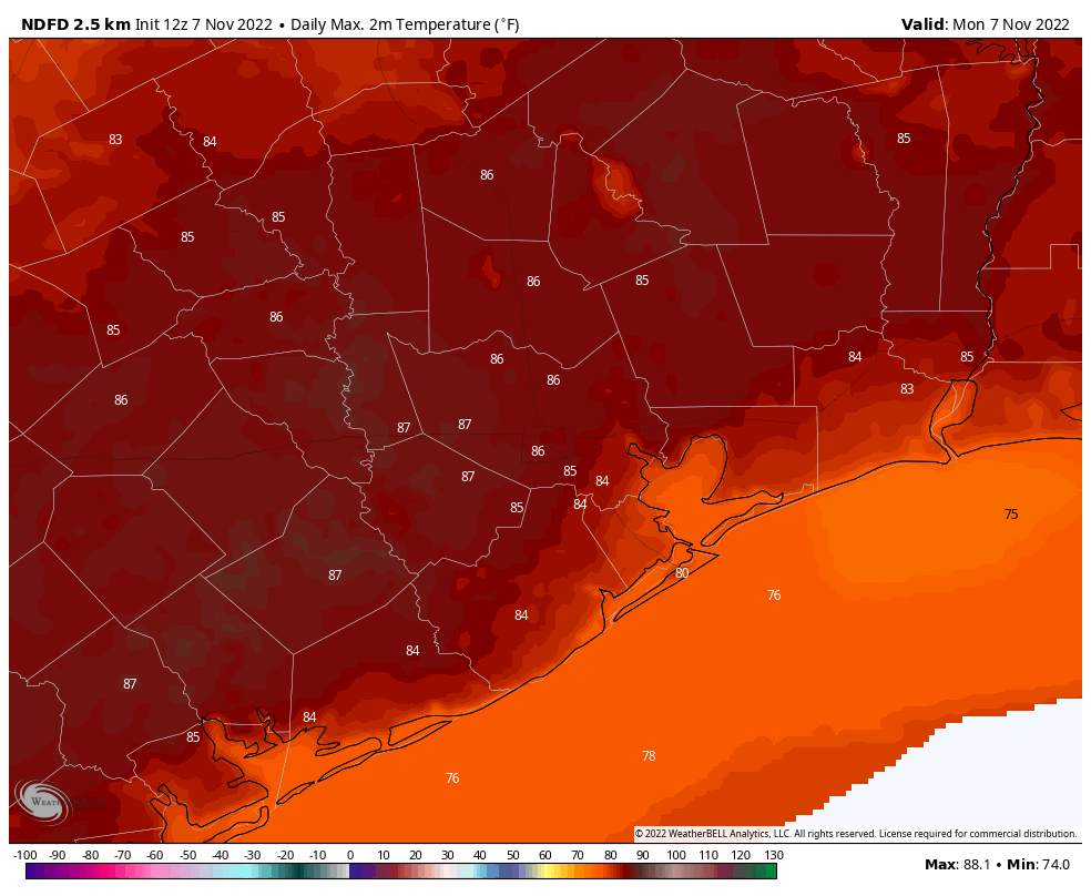
Tuesday
Houston faces a few more days of warmth before cooler air arrives. Today should be the sultriest, with mostly sunny skies, high temperatures in the mid-80s, and plenty of humidity. Winds will be light, out of the southeast, at 5 to 10 mph. We cannot entirely rule out a few isolated showers this afternoon, particularly southwest of Houston, but overall chances are probably on the order of 10 percent. Lows tonight will be a degree or two cooler than Monday night, dropping into the upper 60s for much of the region.
Wednesday
Houston starts trending toward slightly drier air on Wednesday, when we should see highs in the low- to mid-80s, light southeast winds, and mostly sunny skies. Temperatures Wednesday night should drop into the mid-60s.
Thursday
More modestly drier air will start to move into the area from the northeast by Wednesday night, and this will help bring down humidity levels a smidge. Look for highs around 80 degrees, with sunny skies, and overnight lows dropping into the low- to mid-60s.
Friday
Much more significant change is on the way Friday, with the arrival of a strong cold front. It’s not clear whether this will arrive during the daytime on Friday, or the evening hours, but it will bring a surge of significantly drier air into the region. Highs Friday will depend on the timing of the front, but upper 70s to 80 degrees seems like a decent bet. Right now I don’t anticipate too much in the way of showers or storms with the frontal passage, but it’s too early to say much with confidence. I’ll call it a 40 percent chance of rain, for now. Temperatures drop pretty quickly after the front passes, with gusty northerly winds.

Saturday and Sunday
Cold! This weekend will feel more like winter than fall. Both days will see a mix of clouds and sunshine, and high temperatures likely will peak in the upper 50s. Saturday will be a bit blustery, but winds should die down during the afternoon or evening hours. Lows on Saturday night should be the coldest of the week, possibly hitting 40 degrees just north of Houston. Sunday night should be almost as cold.
Next week
Something of a warming trend begins on Monday, but I think we’re going to stay in the 60s for high temperatures, for much of next week. It looks like the overall pattern may favor some mid-week showers followed by a reinforcing blast of colder and drier air. Did someone order winter? Because Mother Nature is door-dashing it to your home.