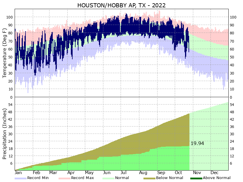
Rain chances shift toward coast as Houston area faces a wet Wednesday

Good morning. Houston’s wet pattern will persist for awhile, but today and Thursday offer the best chances for widespread and heavy rainfall before the precipitation eases back just a bit. Overall we don’t have any real concerns for significant flooding, but we should continue to see the potential for some street flooding beneath the stronger storms. Additionally, we will need to monitor the tropics over the next month, as there are indications that the Atlantic is waking from its long slumber.

Wednesday

Showers will be likely today across the region, with the potential for more widespread rainfall closer to the coast, south of Interstate 10, where the most atmospheric moisture will be. I think much of the region will pick up between 0.25 and 1 inch of rain today, with totals greater the further south one goes. Some isolated areas could pick up 2 to 4 inches within the stronger and slower moving storms. Mostly cloudy skies should help to limit high temperatures to the upper 80s to 90 degrees, and winds will generally be light out of the southwest. Basically, this is a day when you want to check the radar before heading out of doors, just to make sure nothing too intense is headed your way. Rain chances will slacken this evening, with the loss of daytime heating.

NOAA rain accumulation forecast for now through Wednesday. (Weather Bell)

Thursday

This should be a day similar to Wednesday in terms of the overall setup, I just don’t expect showers to be quite as widespread, nor the rainfall quite as heavy. The focus should again be closer to the coast for the stronger showers. For now, I’m thinking ‘Wednesday lite’ in terms of stormy weather, with highs for most of the region reaching about 90 degrees.

Friday, Saturday, and Sunday

Overall, Houston will remain in a pattern favorable for additional rain through the weekend. What should change is that some of the factors that favor heavy rainfall should start to wane, so that we enter a situation where showers spin up and then quickly move along. So for this weekend I think we’re probably looking at partly sunny skies, highs in the 90 to 95-degree range, and perhaps 50 to 70 percent chance of rain. Again I don’t think these won’t be all-day kinds of rains, but you should at least be planning for the potential of a passing shower.

Next week

We’re unlikely to see the return of high pressure next week, so we should see see temperatures continue in the 90 to 95-degree range, with a decent chance of showers during the daytime, and less so at night. It now looks as if this pattern will persist into early September. If you’re wondering whether there’s any hint of fall’s first real front in the medium-range models, the answer is, alas, no. I’ll be a summer bummer and say it is not time for fall yet.

Wednesday morning tropical outlook. (National Hurricane Center)

Tropics

It is time, however, to start watching the tropics. While there is a tropical wave in the deep Atlantic showing signs of life, for the Gulf of Mexico our focus should be on a low pressure system that will move into the Caribbean Sea later this week. There is now a decent amount of support in the ensembles of the GFS and European models for this to potentially develop into a tropical storm next week. The obvious question is, where will it go after that? Expect to see some social media noise during the next couple of days because the operational run of the GFS model, for the last few runs, has been bringing a fairly strong tropical system to the northern Gulf of Mexico coast late next week. However there are a very, very broad range of outcomes here, and the scenario with the most support right now would see a weaker tropical system that tracks more westward, into the Yucatan Peninsula and Mexico. So really, anything can happen.

The bottom line is that this is a system for us to watch at this point, and that should come as no surprise as we’re in the midst of the peak of the Atlantic hurricane season. For now, as usual, be wary but not worried.

Chances for heavy rainfall will persist for a couple of more days

Good morning. Areas north of Interstate 10 saw some additional heavy rains during the overnight hours, but those showers have tapered off this morning. The atmosphere is fairly well worked over as a result, so things should be quiet this morning, and we’ve lifted our Stage 1 flood alert for the northern half of the metro area. But we’ll remain in a pattern favorable for the development of heavy rainfall through at least Wednesday. Additional rainfall totals for most areas should be manageable, at 1 to 3 inches, but we remain concerned about the potential for street flooding beneath downpours.

On the upside, these rains are putting a very nice dent into the region’s drought, and temperatures should continue to run at or below normal levels for the rest of August. This offers a nice reprieve after our record hot June and July.

Tuesday

Skies will be partly to mostly cloudy today, and this should help to hold high temperatures in the upper 80s to about 90 degrees for most of the area. I expect the radar to remain fairly calm this morning, but later this afternoon the potential for showers and thunderstorms will increase. Overall, however, this activity later today does not look too organized. Favored areas for heavy rain will, once again, be located north of Interstate 10 closer to a weak frontal boundary.

Wednesday

It still looks like Wednesday will produce the best chance of widespread rainfall for this week, with area-wide shower chances of 70 percent or higher. I think much of the region will pick up between 0.5 and 1.5 inches of rain on Wednesday. At this point it looks like shower chances will be greatest during the morning hours, so that may be something to watch for with Wednesday morning’s commute. With mostly cloudy skies expect highs to reach the upper 80s, for the most part.

NOAA rain accumulation forecast for now through Thursday. (Weather Bell)

Thursday and Friday

The chance for heavy rainfall will linger toward the end of the week, but we’re going to see conditions favoring such activity start to decrease as the upper atmosphere becomes less supportive. I’d say about 50 percent of the area will see rain each day. Highs probably will return to about 90 degrees, with a mix of daytime clouds and sunshine.

Saturday, Sunday, and beyond

The weekend should see partly to mostly sunny skies, with highs of around 90 degrees. Some decent 30 to 40 percent rain chances will linger on Saturday and Sunday, but at this point accumulations looks slight, and any showers that do form should pass fairly quickly.

Overall, next week, the atmosphere looks to remain unsettled in the absence of high pressure. Look for high temperatures to continue in the neighborhood of 90 degrees, with daily rain chances of 50 percent, or perhaps even a bit higher. We have no significant flooding concerns at this time.

The state of Texas should remain in a fairly wet pattern for much of next week. (Pivotal Weather)

Tropics

The National Hurricane Center continues to track a wave in the Atlantic that is moving westward. However, this wave is encountering a lot of dry air, and development this week is unlikely. Aside from that, things look fairly quiet for several days. However, by next week it does look as though things will start to kick off a bit more. We’ll need to watch the Caribbean Sea for potential activity, as well as additional tropical waves moving off the coast of Africa. Nevertheless, for late August, this is a great place to be when it comes to the Atlantic tropics.

Tonight could be more active than anticipated, so we’re issuing a Stage 1 flood alert for the region’s northern half

Good evening. Just a quick update to say that we’re expecting shower and thunderstorm activity during the overnight hours to be more widespread than previously thought, and that this threat will persist into Tuesday. The greatest risk for heavy rainfall continues to be north of Interstate 10, so we’re issuing a Stage 1 flood alert for parts of the metro area along and north of this freeway. Areas south and west of Houston may also see some heavy rain, but the biggest threat appears to be further inland, to the north.

The problem is that a slow-moving boundary is sagging into the region from the northwest this evening, and it’s finding an environment fairly conducive for additional showers and thunderstorms tonight. In meteorology speak, we’re likely to see the convergence of boundaries that efficiently produce upward motion in the atmosphere. Given the overall tropical air mass, some storms could produce rainfall rates of 2 inches per hour, or higher, which will quickly back up streets. Some parts of the Houston metro area could see an additional 2 to 4 inches of rain overnight, into Tuesday morning, with higher isolated totals. The potential for heavy rainfall, again focused north of Interstate 10, will likely continue on Tuesday.

Locations favored for heavy rainfall on Tuesday. (NOAA)

Here’s the truth: We’re not entirely sure what will happen. We know the ingredients are there for heavy rainfall tonight. It could be a bust, or some location in San Jacinto County could pick up 6 or 8 inches. What we can say for sure is that the atmosphere has potential for heavy rains tonight, and we wanted to call your attention to it. We’ll be back with a full update in the morning.

A rainy week ahead for Houston, but also a cooler one for late August

Good morning. After scattered showers and thunderstorms this weekend, the potential for more organized storms returns to Houston this week, especially areas north of Interstate 10. Most of the region will see 1 to 4 inches of rain through Friday, although isolated areas beneath the heaviest storms could see 6 or more inches. Please note that we’re not looking at continuous rainfall this week, by any means. Monday, in particular, should see a fair bit of sun.

These rains, which will likely reach their maximum coverage on Wednesday, are due to a very moist atmosphere and a series of disturbances in the atmosphere. The overall pattern will support slow-moving storms, which is a concern due to the potential for high rainfall rates. At this time we’re not expecting significant or widespread flooding in the greater Houston area, however stronger and slow-moving storms will likely flood some roadways this week.

NOAA rain accumulation forecast for now through Friday. (Weather Bell)

Monday

Showers today will be fairly scattered in nature, and due to at least partly sunny skies I think we’ll see a warm day with high temperatures pushing into the mid-90s for much of the area. Rain chances are likely about 40 percent for much of the day. However, late this afternoon or evening we should see a line of storms moving through our northern areas, such as Montgomery and Walker counties, in association with a boundary. This line of storms should steadily weaken, before (probably) dying around around Interstate 10. Things should quiet down overnight.

Tuesday

The potential for more widespread rainfall increases on Tuesday, with coverage of 50 to 60 percent of the area. Chances will be highest north of Interstate 10, in places such as Montgomery County. With more clouds, expect highs to peak around 90 degrees.

Areas most favored for heavy rainfall on Tuesday. (NOAA)

Wednesday

This is the day we expect the most widespread rain in the metro area, with chances of around 80 percent. We still don’t have great confidence in the timing of storms on Wednesday, but should be able to offer some better guidance in tomorrow’s post. Highs for most of the area should remain in the upper 80s.

Areas most favored for heavy rainfall on Wednesday. (NOAA)

Thursday and Friday

As the atmosphere starts to dry out some, rain chances should fall back to around 50 percent or so to end the work week. Look for highs of around 90 degrees, with partly sunny skies.

Saturday, Sunday, and beyond

I think the pattern will revert to more typical conditions for late summer this weekend, with partly to possibly mostly sunny skies, and highs climbing back into the low 90s. Rain chances are not zero, but likely will not be higher than 30 percent, or so, and will be driven by the afternoon sea breeze. If you were expecting us to fall into a high-pressure dominated hot weather pattern next week, don’t. All indications are we’re going to see healthy rain chances through the end of the month, with moderate highs in the low 90s.

Tropics

We are now officially in the heart of hurricane season for Texas, and the entire Atlantic basin. For us, this period runs for about the next six weeks, when the state is most vulnerable to hurricanes, and the Gulf of Mexico at its warmest to support them. So far, it has been a quiet year in terms of Accumulated Cyclone Energy, a measurement of the duration and intensity of tropical systems. The Atlantic basin has seen just 13 percent of its average cyclone energy through this week, according to hurricane scientist Brian McNoldy.

Accumulated cyclone energy is well below normal in 2022, so far. (Brian McNoldy)

The tropics are waking up, however. A tropical wave that recently moved off of Africa has a chance of developing this week as it traverses the Atlantic, although it will have to combat a fair amount of dry air over the next several days so it may dissipate. Behind this wave there are more, so we should expect to see activity continue to tick up. But the good news is that the season is slower than anticipated so far, and there’s no reason to think any of these systems are going to track near the Gulf of Mexico any time soon.