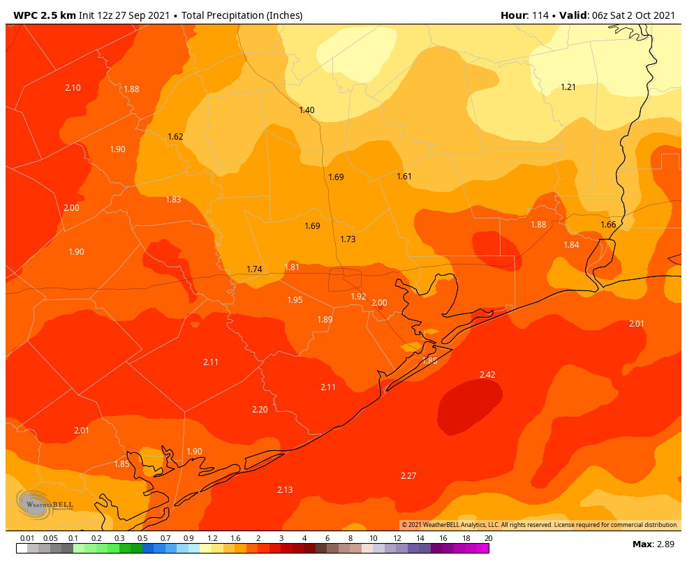
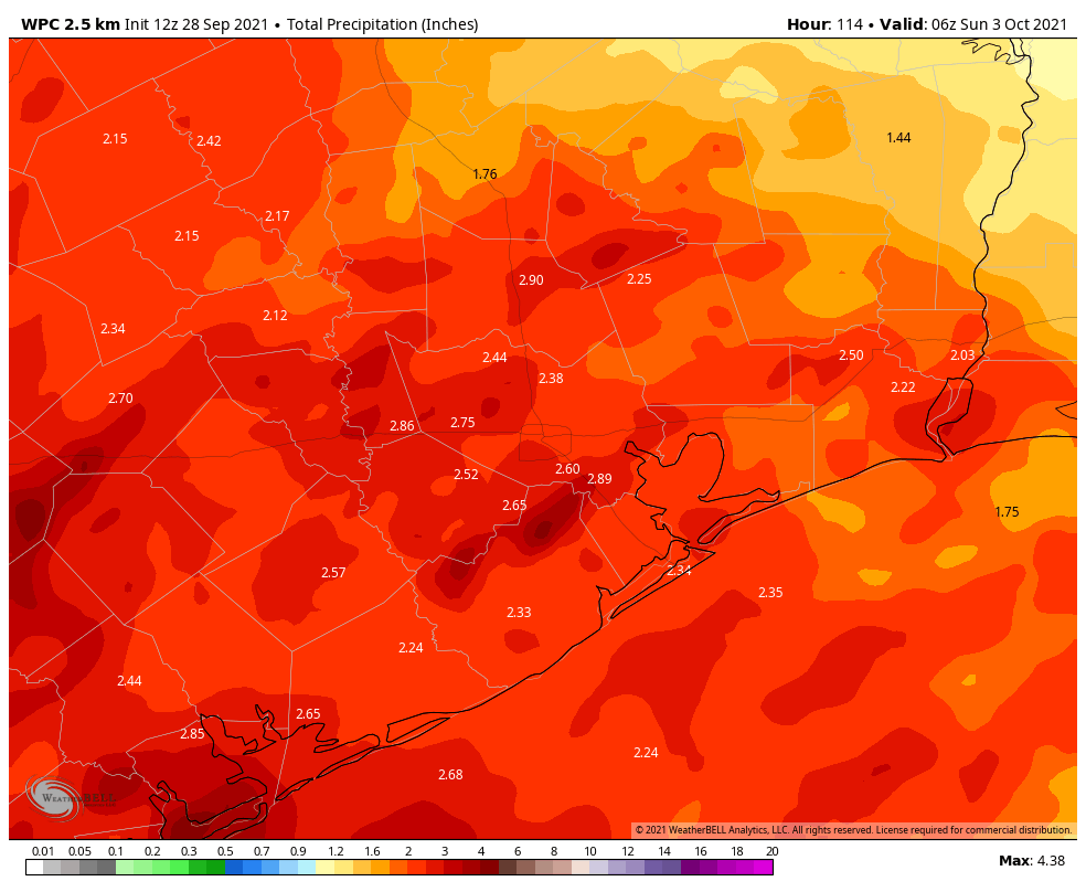
The Gulf storm: What to expect, and when to expect it

Before jumping into the updated forecast, I want to remind new readers of the ways in which they can get notified of our posts on Space City Weather:

  • Download our free mobile app for Android and Apple devices
  • Receive all posts by email, using the “Subscribe via email” form on the right side of this page (desktop version) or bottom (mobile version)—we’ll never spam you
  • Follow us on Twitter, Facebook, or Instagram
  • Read our website translated professionally into Spanish at Tiempo Ciudad Espacial

Ok, now on to the forecast. With this evening’s post we are going to give a general sense of the timing for what to expect, and when. We have some answers about the near-term forecast through Monday, but the bigger and perhaps more important question concerns what comes in the middle of the week.

The GFS ensemble forecast provides insight into the range of possible outcomes for the track of Invest 94L. (Weather Bell)

Invest 94L

As of Saturday afternoon, the Gulf storm, or Invest 94L, remains poorly organized (see for yourself). It is difficult to assign a center to the low pressure system, and this lack of definition is one reason why forecast models are struggling a bit. However, the overall picture seems fairly clear. As the system moves northwest across the Bay of Campeche, it is likely to become better organized on Sunday, and should become a depression by Sunday night or Monday. By that time it should be approaching the northern Mexico or southern Texas coast. After this things the forecast becomes murky. By Monday night or so, the system may either move inland near the Rio Grande River, or turn northerly and track up the Texas coast. If it remains offshore, Invest 94L has a chance to become a reasonably strong tropical storm on Tuesday.

Sunday

Skies should remain mostly clear overnight, but clouds will begin to build across the upper Texas coastal region on Sunday. However, for much of the day any showers and thunderstorms we see should be scattered in nature.

Monday and Monday night

By Sunday night or Monday morning we should start to see more organized storms moving in from the southeast, off the Gulf of Mexico. It’s important to note these rains will not be directly related to the core of Invest 94L, which will remain far to the south. However, as a slug of moist tropical air moves inland we should see widespread accumulations of 1 to 3 inches for inland areas, and 3 to 5 inches of rain for coastal counties. We can’t rule out some bullseyes of 7+ inches. It seems possible that this initial round of storms may wind down on Monday evening or over night.

NOAA rainfall forecast for now through Monday night. The key is what comes afterward. (Weather Bell)

Tuesday and Wednesday

The real question is what comes after this point, and that will be determined by what the center of Invest 94L does. If the storm’s core moves up the Texas coast (the “Coast hugger” scenario in this morning’s post), our region would probably see manageable rain totals on Tuesday and Wednesday, with the heavier rains offshore or falling over southwestern Louisiana. However if the low moves into Texas and then wanders upward through state—perhaps along the Highway 59 corridor or further inland as in the “Tour of Texas” scenario—we could see a second round of even heavier showers on Tuesday night and Wednesday. For now, it is impossible to say which of these situations will play out, but ultimately this is probably the most important thing to watch in terms of flooding for the greater Houston region. If we’re going to get rocked, it probably would come then.

Our confidence is reasonably high that the rainfall event, whatever comes our way, will begin to wind down on Wednesday afternoon or evening.

Matt will have a full update in the morning, and we’ll have all-hands-on-deck coverage with myself, Matt, and Maria tomorrow.

Tropical system moving into Gulf, heavy rains likely next week

Good morning. It’s going to be a beautiful Saturday in Houston, in early September. We totally understand that people are focused on 9/11 remembrances, family gatherings, or other activities today. But there is a potentially serious weather situation developing in the Gulf of Mexico that you need to keep one eye on this weekend. I say potentially because there are some scenarios in which Houston sees only moderate rainfall, and there are others in which we get drenched.

The satellite appearance of Invest 94L at sunrise on Saturday is not overly impressive. (NOAA)

Here’s what we know for sure: It is highly likely that a tropical depression or storm will form over the southwestern Gulf of Mexico within a day or two. This extremely moist system will bring heavy rains, winds, and high seas to the Texas coast beginning late on Sunday. But it’s the details that matter, and we can’t pin those down yet. Based upon the latest modeling and the atmospheric setup, I want to present three plausible scenarios for the next week. As we will discuss, the effects range from mild to extreme, and that’s one reason why it is so difficult to provide an accurate forecast at this time.

Three scenarios

The map below shows the European model’s ensemble forecast for the evolution of the tropical system, which has been designated Invest 94L. It shows tracks from Friday night through Tuesday evening, and I’ve boxed what I consider three of the most likely possibilities. Let’s discuss each of them.

Three potential scenarios for Invest 94L. (Weathernerds.org/Space City Weather)

Scenario A: Coast hugger

In this case the storm moves close to the Texas coast on Monday, but perhaps doesn’t come fully ashore. It then moves fairly rapidly to the north and then northeast, bringing its center close to the Houston metro area on Tuesday or Wednesday. In this case we would see higher tides—although probably not too great of a storm surge—and wind gusts of tropical storm force in the metro area. However, the heaviest rainfall would likely fall off the Texas coast and potentially in southwestern Louisiana. In this scenario Houston might see 2 to 4 inches of rainfall, with the 20-inch bullseye remaining offshore.

Scenario B: Tour of Texas

In terms of rainfall, this scenario is more ominous. A likely weak tropical storm would move into South Texas on Monday or so, and slow down for a couple of days. The center would remain close enough to the coast that the storm would be able to tap into Gulf of Mexico moisture. In this case, Houston might expect 5 to 15 inches of rain, with a 20-inch bullseye of rainfall coming somewhere in the area from Corpus Christi to Beaumont. But it’s impossible to say where. The potential for heavy rainfall would linger through Wednesday. Winds and seas would be much less of a factor.

Scenario C: Riding the Rio

It still is possible that the low moves into northern Mexico and basically tracks along the Rio Grande River, dying out after a few days of being inland. In this case the Texas coast would see some moderate rainfall for a few days, but totals for most areas would probably be 2-4 inches, or even less. This scenario seems a little less likely at this time, but it would certainly have the most benign effects for Houston.

This is the latest six-day rainfall forecast from NOAA, but it is only a very rough guide, and localized amounts could be much higher. (Weather Bell)

Conclusions

So what actually happens? I wish I could tell you. But we’re talking about a tropical wave that has yet to form a semblance of a circulation, so the forecast models are going to struggle with its track. After that, it’s not entirely clear how much the wind shear currently hampering its organization will weaken over the next couple of days as the system moves northwest or north toward Texas. And these are just the beginning of our questions.

The bottom line is that Saturday should see fine weather in Houston. Sunday should start out sunny as well before rain and thunderstorm chances increase during the afternoon and evening hours. After that heavy rainfall is possible through Wednesday, and we just really can’t say how much. But this is a forecast you should be monitoring closely. We’ll have an update later this afternoon or evening.

Houston faces a Stage 2 flood alert beginning Sunday evening

To set expectations for next week’s heavy rains, we plan on implementing a Stage 2 flood alert on our flood scale, and anticipate this warning will be in effect from Sunday evening through Wednesday. This is what we mean by Stage 2 on our five-point flood scale:

Events falling into this category may cause significant, widespread street flooding across large swaths of the area, flooding numerous cars. Other examples of what we would consider stage 2 events are ones that flood dozens of homes in small, targeted areas or specific neighborhoods. These events are either moderate impact over a large area or high impact over a relatively small area.

A couple of notes on this before we jump into the forecast. First of all, it is quite early to be calling for this, as heavy rain is unlikely to arrive before Sunday night at the earliest. However, since most people probably will check out over the weekend—much of which will be sunny and pleasant—we wanted to give our readers a heads up now. Second, since we are issuing this flood alert early, it is very much subject to change. And finally, the area of greatest risk lies south and east of Houston, so that’s where we think Stage-2 like effects are most likely.

As to the overall forecast, not a whole lot has changed. There remain a number of meteorological variables that we can’t yet predict with great precision, and so the forecast models are struggling with rainfall totals. For example, a model might forecast 15 inches of rain for a location in one run, and drop to 5 inches the next run.

There is fairly good consistency, however, on the overall setup favoring heavy rainfall somewhere in Texas or Louisiana. (Or both!) So if you live within 50 miles of the coast, between Corpus Christi and Lake Charles, you’re potentially under the gun. In terms of accumulations, we anticipate 2 to 6 inches for most locations, but what we’re concerned about is potential bullseyes of 10+ inches. It looks like the most likely period for heavy rainfall will run from Monday through Wednesday.

NOAA rainfall forecast for now through Thursday. (Weather Bell)

The bottom line is this: Enjoy your weekend, but also be prepared for the possibility of heavy and potentially disruptive rainfall early next week.

We’ll update on Saturday and Sunday with the latest.

Delightfully dry for a few days before a much wetter pattern returns

Good morning. Houston should remain in a drier pattern through the first half of the weekend—Friday evening through Saturday morning looks especially pleasant—before much wetter weather arrives by Sunday. As tropical moisture increases, so will rain chances, and we’re tracking the potential for heavy rainfall from Sunday night through the early part of next week.

Thursday

The next weak front is located north of the metro area, but should slide into the region today. There will be a subtle shift in winds from the northwest to the northeast, but skies should remain sunny regardless. Accordingly highs will be toasty today, likely reaching the mid-90s, with the possibility of a few locations seeing the upper 90s. Lows tonight will drop into the low 70s in Houston, with the potential for upper 60s further inland.

Saturday morning’s low temperatures will be fine for mid-September. (Weather Bell)

Friday and Saturday

This looks like a pretty stunning period, at least as September goes, through about Saturday evening. The driest air should push into the region on Friday, with the potential for dewpoints to drop into the 50s. Expect daytime highs around 90 degrees, with sunny skies, and lows Friday night in the upper 60s across much of Houston.

Saturday night through Monday

The period turns sharply wetter with the arrival of tropical moisture beginning Saturday night or Sunday morning. The overall threat is still not particularly well defined, but a tropical wave should move into the southern Gulf of Mexico this weekend, and associated moisture will push into the Texas coast. The forecast models are hinting at some significant rainfall totals from this, especially for locations closer to the Gulf of Mexico. For now, as a guess, we’re probably looking at rain totals of 3 to 5 inches south of Interstate 10, with lesser amounts inland through early next week. Our main concern is the potential for higher localized rain totals. It’s impossible to say where that will happen, but the potential is there.

After Monday

A fairly wet period should persist into the middle of the week, with sunnier weather potentially returning by Thursday or so. Until that time highs will only be around 90 degrees, with muggy nights in the upper 70s. Those deliciously low dewpoints will be long gone.

Thursday morning tropical outlook. (National Hurricane Center)

Tropics

It’s September 9, so as usual there is a lot of activity in the tropics. But for the western Gulf of Mexico we need only concern ourselves with the aforementioned tropical wave. This feature, which we’ve mentioned several times this week, is now given a 30 percent chance to develop into a tropical depression or storm by the National Hurricane Center. The most likely outcome is that the system will move into the Mexico coast, or possibly south Texas, but we can’t entirely be sure of that yet. In terms of the overall rainfall threat early next week, it probably won’t matter too much.