Last really hot day before—gasp—rain chances return Friday

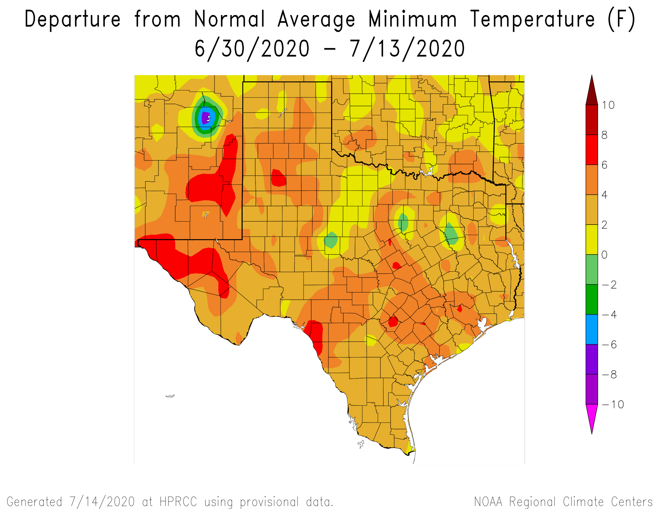
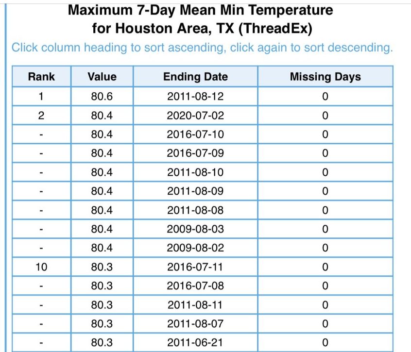
It’s another sticky morning across the Houston region, with lows at 80 degrees or above for most of the region. Normal lows this time of year run about five degrees cooler so the real heat this month has come during the nights. We expect the overnight lows to moderate slightly over the next few days, but we’ll remain at least in the upper 70s. The bigger change will be apparent in daytime highs, as we fall back toward the low-to-mid 90s after today.

Thursday

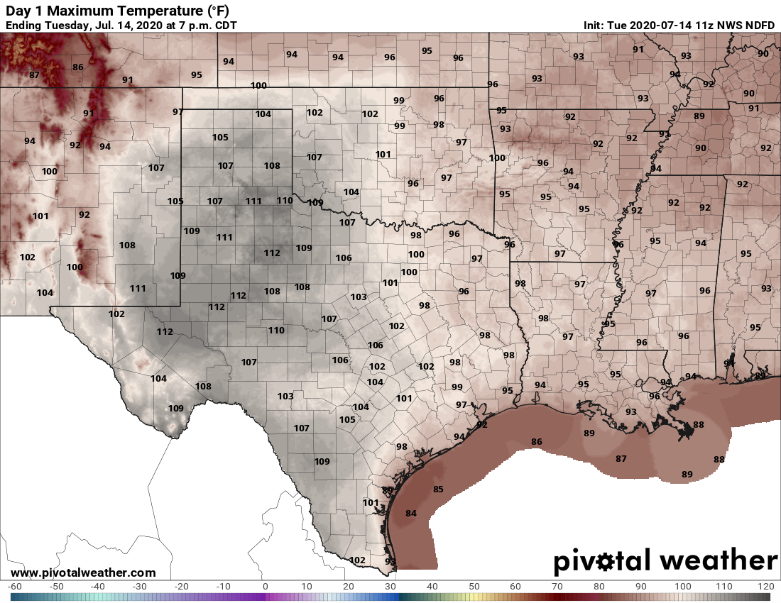
If you liked Wednesday’s weather then you’re in luck, because today will bring more of the same. Although high pressure should begin to weaken, it’s still going to retain enough of a grip to send high temperatures soaring into the upper 90s across the area. Morning clouds should give way to afternoon sunshine.
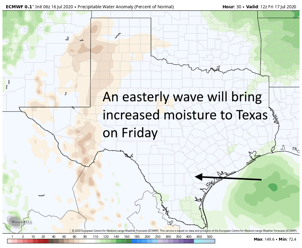
One effect of an easterly wave on Friday will be increased moisture levels. (Weather Bell)

Friday

Our weather pattern should really change on Friday. Highs pressure will back off just enough to allow a weak low pressure system to move from east to west across the area. This should bring scattered, light to moderate showers along the coast during the morning, and spread inland during the afternoon and evening hours. Will you get rain? If you live south of Interstate 10, chances are probably in the 50 percent range, and lower if you live north. Accumulations for some may be up to one-half inch, but most people will see less than this. Highs should otherwise be in the mid-90s.

Saturday and Sunday

The weekend should see fairly standard weather for Houston in July, which is to say highs in the low- to mid-90s, with partly to mostly sunny skies. We may see some isolated to scattered showers driven by the sea breeze, but overall rain chances will be quite low.

Next week

Most of next week should see highs in the low 90s, with a mix of sunshine and clouds. On average, each day should have around a 30 percent chance of rain, but of course some days will have better and worse chances. We’ll refine that forecast as we get closer to it.

After record-setting warm nights, some relief looms at last

So it’s been hot in Houston this month, especially the nights. The low temperature this morning at Houston Hobby Airport is likely to fall no lower than 81 degrees. This would make for the tenth day so far in July that the temperature has failed to fall below 80 degrees at that location. This extends a new record for mornings with 80- degree mornings, or above, for the month of July. The previous record for the most of these days at Hobby was eight, in 2016, according the National Weather Service. Also, July is not quite half over yet.

Low temperatures in the Houston region have been 4 to 6 degrees warmer than normal in July. (Unl.edu)

Fortunately, some scant relief is coming as the high pressure that has dominated our weather this month begins to weaken and slide east. This will slowly bring down temperatures and, eventually, introduce some moderate rain chances to the area. We think the second half of this month will be much closer to “normal” for a Houston summer than the extremely warm nights and days we’ve experienced over the last two weeks.

Wednesday

Today, however, will not provide too much of a change. Highs probably will still reach into the mid- to upper-90s for the region, with partly to mostly sunny skies this afternoon. Winds from the south at 5 to 10 mph will provide a bit of relief, and then we will be in for another very warm night, with lows possibly falling into the upper 70s for inland areas.

See full post

Another day of extreme heat before Houston slowly returns to “normal” summer

Houston recorded its third 100-degree day of the year on Monday, when the high reached 101 degrees at Bush Intercontinental Airport. Hobby Airport also recorded its warmest day of the year, with the high hitting 99 degrees. Today will be another scorcher, but then our weather should gradually begin to modify toward more “normal” summertime weather in Houston. Later this week we’ll see the development of clouds, and even some modest rain chances as the high pressure system that’s been dominating our weather weakens.

Tuesday

Alas, there won’t be much (or any) relief today. We’re in for more hot and sunny conditions which should send highs back into the upper-90s—today is probably the region’s last day to break 100 degrees for awhile. Winds will be out of the south at 5 to 10 mph. And once again, overnight low temperatures will likely not fall below 80 degrees for much of the area, and only briefly if they do.

Tuesday’s forecast: Damn hot.

Wednesday and Thursday

These should be a pair of hot and mostly sunny days with highs in the mid- to upper-90s. Rain chances remain minimal, but overnight lows should be a degree or two cooler.

Friday

By week’s end a bit of an atmospheric disturbance may move through the area, and this will provide the region’s first real chance of rain in quite a while. I don’t want to oversell this as rain chances right now look to only be about 30 to 40 percent. And oftentimes, after an extended period of dry weather, forecast models will oversell rain chances. But anyway, the combination of scattered showers and a few more clouds should limit highs to about 95 degrees.

Saturday and Sunday

The weekend looks mostly sunny, with a slight chance of rain, and highs in the low- to mid-90s. This will feel more like a typical July weekend in Houston.

Our weather pattern should turn a bit wetter next week. (Pivotal Weather)

Next week

The pattern next week does look more favorable for rain, with high pressure displaced. Expect highs in the low- to mid-90s with decent rain chances beginning on Monday or so.

Houston days, and nights, have been extremely warm

Good morning. Do you remember the brutal summer of 2011? If not, that was the warmest summer on record in Houston—high temperatures failed to reach 100 degrees on exactly one day in August of that year. Most of us who lived through it will probably never forget it.

Well, during the last week Houston has had warm nights that rival the summer of 2011. Matt found that the week ending Saturday morning capped off the warmest 7-day stretch of minimum temperatures on record in the city. For the last 7 days low temperatures have averaged 80.7°. The previous record is 80.6° set in 2011.

Warmest 7-day average minimum temperatures in Houston. (National Weather Service)

That gives you some sense of the magnitude of heat we experienced last week, and which will continue this week. To that end we wanted to remind you that today through Wednesday is the very last chance to enter phase 1 of Reliant’s sweepstakes to win a free AC System. Please visit here to enter for your chance to win. Good luck!

Monday

By now you know the drill as high pressure dominates our region’s weather. Highs today will again be in the upper 90s, with partly sunny skies in the morning giving way to mostly sunny skies during the afternoon. Winds will be light out of the southwest. Overnight lows ill provide scant relief from this weather, possibly not dropping below 80 degrees.

See full post