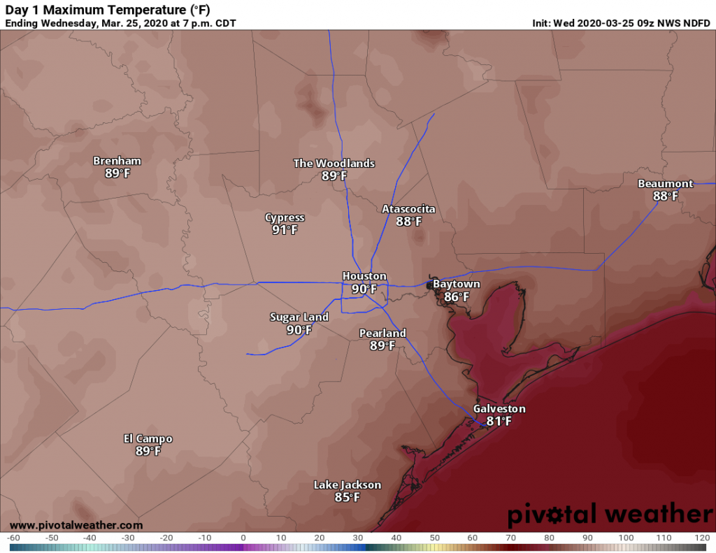
Tropics coming alive, but we see no imminent Gulf threats

Welcome to the weekend, everyone. We’ve had several questions about tropical activity during the last day or so as the National Hurricane Center has highlighted a couple of areas for likely tropical cyclone formation. None appear likely to present a threat to Texas, but we’re posting anyway to address those questions, and allay concerns. This is also a good reminder that we’ve reached the peak of hurricane season, and the next month, historically, is the time of most concern for Texas.

Here’s the latest five-day map from the National Hurricane Center showing the two systems of Interest, to which we’ve added their “invest” designations.

(National Hurricane Center)

Invest 98L

Forecast models indicate this system has a strong chance of becoming a tropical storm or a hurricane, but the preponderance of tracks develop it after the system has moved away from Florida, and it will likely present no significant threat to land.

Invest 99L

The track of 99L appears to be a little bit more ominous, as it brings the system toward the Caribbean Sea. The National Hurricane Center gives it about an 80 percent chance of developing into a tropical depression or storm. However, the global models generally anticipate that any system that might develop will fall apart somewhere in the general vicinity of Hispaniola due to unfavorable wind shear.

Certainly it will be worth watching the evolution of 99L over the next week, as there are some scenarios in which it tracks into the Gulf of Mexico. But by far the most likely outcome is a) dissipation or b) some kind of rainfall threat to the Caribbean Sea or Florida over the next five to seven days. As always, if this changes, we’ll update the site.

The coast will be wet for awhile, but we’re hopeful about next week

Good morning. Houston’s hit-or-miss rainfall pattern appears likely to continue from now through the weekend. The pattern will include more hits along the coast, and more misses for areas inland of interstates 10 and 69, as the further one is from the Gulf, the less access to moisture there will be.

Thursday

This morning will bring mostly sunny skies to the region, but in what is now becoming a familiar pattern, scattered storms will migrate inland beginning around noon for areas along the coast. Through the afternoon and early evening hours, the storms will then progress across central parts of Houston, and then exit northward. Perhaps 40 percent of Houston will see rain, and a fraction of that will see some fairly heavy, if brief rainfall. The rest of you will see dark clouds in the distance, and perhaps hear the rumble of thunder. Highs will be in the mid- to upper-90s, and this will depend on how clouds develop over your location during the peak heating of the mid-afternoon hours.

NOAA rain accumulation forecast for now through Saturday. (Pivotal Weather)

Friday and Saturday

As we’ve been talking about, a plume of more moist air will be moving north across the Gulf of Mexico at the end of this week, pushing up rain chances and likely driving down temperatures into the low-90s. Your weather for the first half of the weekend is going to basically depend on how far you live from the coast. Inland locations such as Katy will probably see mostly sunny days, with higher temperatures and slight, if any rain accumulations. But coastal areas such as Clear Lake or Galveston have a better chance of rain, and may potentially see accumulations of 1 inch or more of rain. Bottom line? Perhaps this isn’t the best weekend to head to the beach.

See full post

A few areas have missed out on Houston’s rain this week

The first two weeks of August were incredibly hot and dry, but since then Houston has moved into a more typical summertime pattern where most days have produced at least a smattering of rain showers, with more widespread, heavier thunderstorms some days. However, in looking at a cumulative rain map over the last 10 days of this month, there are some areas that have stayed dry—including places like Spring, Katy, and Tomball.

Rainfall roulette over the last 10 days. (Matt Lanza)

If you’ve missed the rain train so far, you’ve got several more days of healthy rain chances ahead. We look to remain in a fairly wet pattern through the weekend, with perhaps Friday offering the best overall chance of showers this week.

Wednesday

Today should be similar to Tuesday, albeit with slightly less coverage. Overall, skies should be mostly sunny, with storms popping up around noon just inland from the coast and migrating into the interior of the region by around 6pm or so. They should end by or before sunset. Similar to Tuesday, some of these storms could be fairly intense, with short-lived, high rainfall rates that quickly drop an inch or so. Let’s go with a 30 percent chance of rain, with highs in the mid-90s.

Thursday

Another day similar to Wednesday, with slightly better shower coverage as the Houston area begins to open up to Gulf moisture. Let’s call it 40 percent rain chances with highs in the mid-90s.

See full post

Somewhat wetter pattern likely for this weekend in Houston

Houston will remain in a more or less static weather pattern for most of the remainder of this week. Each day will see a healthy chance of showers, with a crescendo toward the weekend, but for now there don’t appear to be any significant concerns about strong storms or flooding. Temperatures will be hot, of course, but typically not of the 100-degree variety we sometimes see in August. In short, this is not a bad way to spend the last 10 days of a month that can either bring high pressure domes of doom, or serious tropical weather.

Low temperatures on Tuesday morning are sultry clear across the state. (Weather Bell)

Tuesday

Today should be similar to Monday, with a mixture of clouds and sunshine, and highs in the mid-90s for most of the area. Rain chances are probably about 40 percent for most of Houston, with showers pulsing up near the coast by late morning, and moving through the city during the afternoon hours. They should fade as the sun begins to set. Some storms may briefly bring rainfall rates of 1 to 2 inches per hour, but most people will see far less than that.

Wednesday and Thursday

These have the look of typical summertime days, with highs in the low 90s along the coast, and upper 90s for inland areas. Shower development should occur along the sea breeze, which will migrate inland during the afternoon hours. Right now I would anticipate less coverage than on Tuesday, so let’s call it 30 percent rain chances on both days.

See full post