A night of very heavy rainfall and flooding has begun for Houston

We have seen very heavy rainfall develop along and northwest of Interstate 69 this evening. Areas near the Addicks and Barker reservoirs have been especially hard hit, some of which have received 5 inches of rain since 6-9pm. Water levels in the reservoirs are rising, but still well below flood level as of 8:45pm CT. With flood warnings issued, and street flooding occurring across much of west, northwest, and north Houston this evening, travel should cease for the night. It is time to hunker down.

As for the rest of the night, we expect this mass of rains to the northwest of I-69 to hold together until around 10pm or 11pm, after which time it should begin to sag slowly to the southeast. After this time we expect most of the action to occur more close to the coast, on the southeastern side of I-69. In addition to this sagging mass of showers, another complex of storms will move up from South Texas, likely reinforcing the already existing coastal showers.

Houston radar at 8:45pm CT shows mass of shower northwest of I-69. (kktv.com)

Given the totals we’ve seen so far, widespread totals of 4 to 8 inches seem possible for areas northwest of Houston tonight, with higher isolated totals. Elsewhere, totals are likely to be closer to 1 to 4 inches of rain, with isolated areas of 8 inches possible later tonight.

In addition to the heavy rains, we are seeing reports of hail, up to 2 inches in diameter, across much of the area. This will continue for the next couple of hours, and we may also see the potential for damaging straight-line winds later tonight. An unpleasant night, for sure.

A reader image of golf-ball sized hail in Cinco Ranch Thursday night.

Storms will eventually exit to the east, with rains likely ending across the area from 6 to 10am on Friday morning, from west to east. Then we can probably expect another wet night Friday night, although hopefully not as extreme.

Storms holding off mostly Wednesday, we’re still wary though

In this morning’s post, I wrote that there was the “potential” for storms and heavy rainfall today, but we didn’t have any confidence in whether it would materialize or not. Fortunately, so far the storms have not materialized.

Our biggest concern today has been a broad line of showers and thunderstorms moving eastward across central Texas today, associated with a cold front. High resolution modeling suggested this line would weaken as it approached the Houston area, and in fact that is what has happened, which is good for Houston. See the comparison below of radar images from earlier this afternoon.

Radar images from earlier (top) and later (bottom) this afternoon. (kktv.com/Space City Weather)

As this broken line of showers and thunderstorms moves into the Houston area this afternoon and evening, the most likely outcome is that the system does not get too organized over the city. The best chance of storms will probably come to the north and east of Bush Intercontinental Airport, and the good news is that the storms seem to be holding a fairly steady eastward motion which should help to limit storm totals. As a result I think most of the area will probably see less than 0.5 inches of rain later today and tonight, with a few unfortunate pockets perhaps picking up a quick 1 to 3 inches.

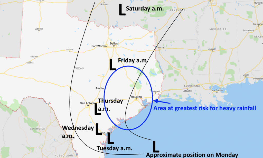
We expect a fairly calm start to Thursday, before more showers later Thursday into Friday morning, and then yet another round from Friday night into Saturday morning. We’ll have full coverage of that tomorrow morning.

After torrential Tuesday, more heavy rain coming

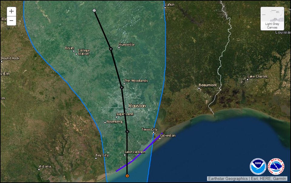
By several measures, Tuesday’s rains were exceptional for parts of the Houston metro area. According to the Harris County Flood Control District, one gauge in Sugar Land recorded 5.16 inches of rainfall in 1 hour and 15 minutes, and multiple other parts of the city saw rainfall rates nearly that extreme, which will quickly overwhelm the capacity of urban roadways. Tuesday’s commute was an absolute mess. Moreover, unofficially, an estimated 400 homes flooded in Kingwood. The Brazos River at Richmond has already reached a minor flood stage. Because of the unexpected intensity of Tuesday’s precipitation, and the potential for more heavy rainfall over the next four days, we are raising the expected impacts from these storms to Stage 3 (out of five levels) on our new flood scale.

Fortunately, the storms finally died down between 9pm and midnight on Tuesday, allowing the area a reprieve during the overnight hours. This allowed several creeks and bayous near the tops of their banks to begin receding, although many remain higher than normal. So let’s discuss what happens next.

Wednesday

The unstable, very moist atmosphere that produced widespread heavy rainfall on Tuesday more or less remains in place today, and this should fuel at least some scattered showers and thunderstorms throughout the daytime in the city. We do not believe these storms will be as widespread as on Tuesday, but certainly with some of the more slow-moving systems some areas could pick up a quick 1 to 3 inches of rainfall. Overall, however, most of the city will probably receive less than 1 inch of rain today.

Severe weather outlook for Wednesday. (NOAA)

Our other concern stems from an upper-level disturbance and cold front now bringing storms to west and central Texas. This should move toward the region this afternoon and evening, bringing with it the potential for severe thunderstorms toward Houston. While most of the action will probably remain north of Houston, NOAA’s storm prediction center has brought the region where there is a “slight” chance of damaging winds, hail, and potentially tornadoes down to about the Interstate 10 corridor. This will be worth tracking.

Basically, today is a day of “potential.” The unstable atmosphere could produce a very wet day, almost like Tuesday for some areas. Or showers could be much more scattered in nature—our high resolution models have performed so poorly of late it’s just hard to say for sure. Similarly, the upper-level disturbance could remain far enough north of the metro area such that it will not cause major problems—or not. We’ll be monitoring throughout the day for you.

See full post

Heavy rains, multiple flood warnings … and it’s just Tuesday

Earlier, we posted that we expected the heavy rainfall to wane between 6pm and 9pm this evening. Unfortunately, the storms have sustained themselves as the sun has gone down and continued to pile on rain totals—especially to the southwest of Houston in areas such as Sugar Land and Richmond. Regions there have now recorded 8 to 10 inches, nearing the exceptional amounts recorded in Humble and Kingwood earlier today and this afternoon.

Tuesday rain totals were very impressive NE and SW of Houston. (HCOEM)

So what happens now? With the sun now falling below the horizon, the rain cooled atmosphere will have less energy to sustain itself, and from a pure physics point of view, these heavy rain showers really should really ebb over the next 3 to 6 hours. But it is hard to have overly much confidence in this forecast given how much we’ve missed already today. We’re hoping for a break later tonight and perhaps Wednesday morning.

Where does this leave us? Quite frankly, we didn’t anticipate that the rains would be as intense as they were today. Certainly, we didn’t expect 10 inches of rain for any part of metro Houston, nor the need for high water rescues as are presently ongoing in southwest Houston. Yet here we are on the first day of a multi-day event, with soils now thoroughly sodden; some bayous near bank full; river concerns; and more.

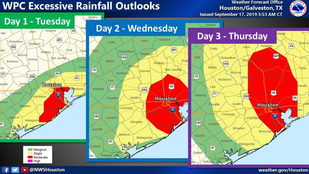
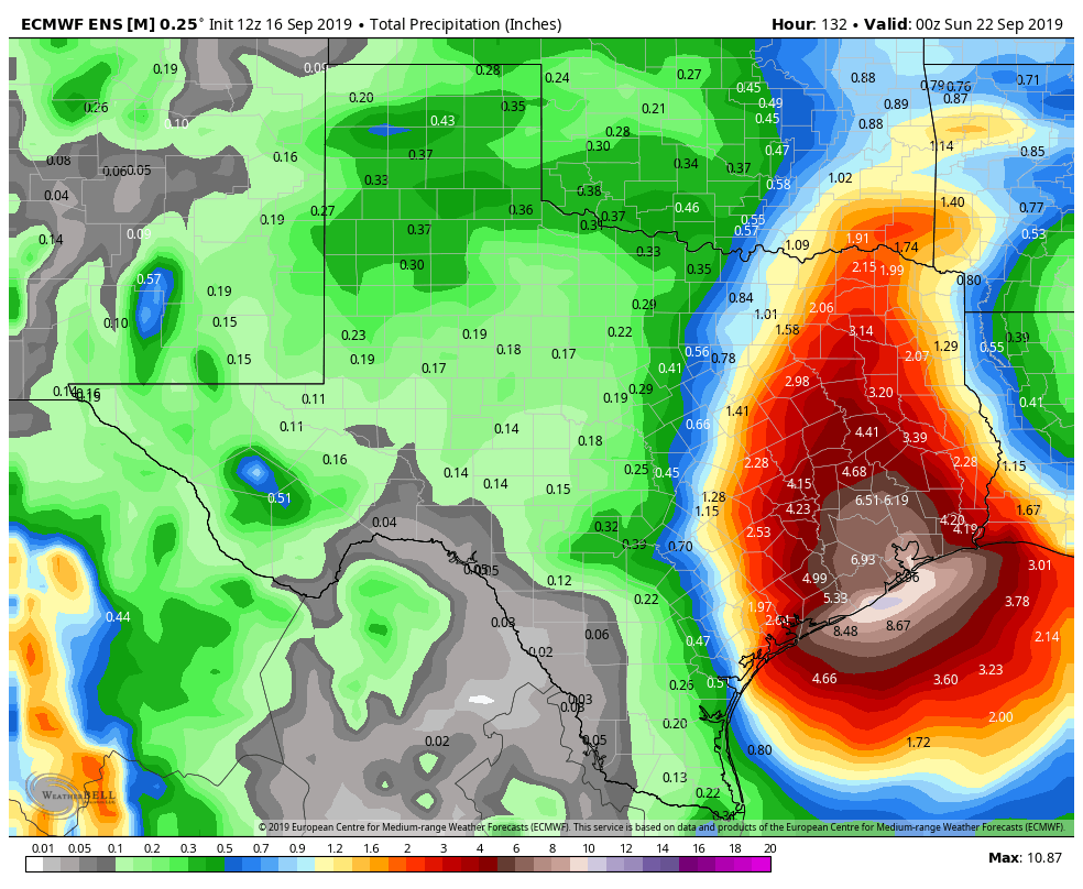
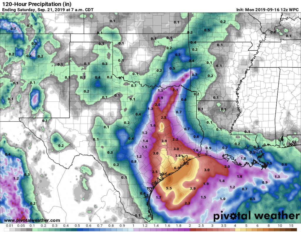
Forced to guess, I’d say we’ve got two more major rounds of storms to worry about after this evening. There likely will be widespread showers on Wednesday night and Thursday, and then some kind of mess on Friday and Saturday. If those rounds are as bad as we’ve had today, then we’re going to see a much worse situation than now, but I don’t think we can quite say that yet.

We’ll be back with a full report in the morning.