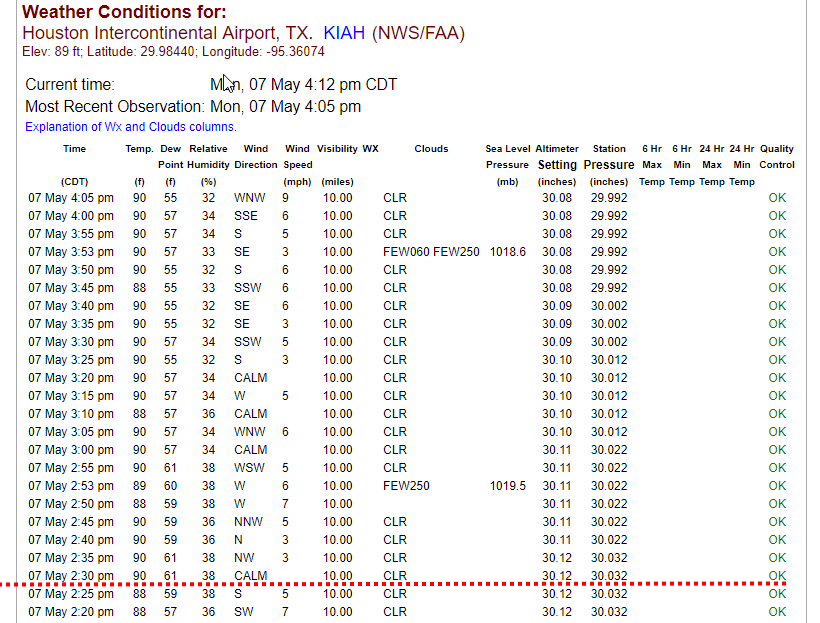
Houston is hot, eclipse coming, and tropics active

Houston remains in a typical August-like pattern, with high pressure largely in control of our weather, but not dominating. Were a strong high overhead we’d be having temperatures around 100 degrees, with no chance of rain. But since the high isn’t dominant, there’s a chance for some scattered rain showers each day. Mind you, most of Houston isn’t going to see rain through Saturday, but there is at least a chance. Since the forecast is rather dull we’ll also talk about the tropics and eclipse weather today.

Wednesday to Saturday

See above. Hot, with highs in the mid- to upper-90s. Warm nights. Mostly sunny. A few showers will develop during the afternoon hours.

Sunday to Tuesday

Pressures fall a bit, allowing for slightly better rain chances, perhaps in the 30 to 40 percent range each day, with the higher end chances for the eastern half of the area. These probably won’t be real soakers—likely some areas will see a couple of tenths of an inch of rain, while most of the area won’t see that much, if any rain. Highs may pull back to the mid-90s. That’s still hot, but we’ve certainly had hotter Augusts.

See full post

One silver lining about August in Houston—this too shall pass

We have reached the real dog days of summer. The middle of August almost always feels like this, with low temperatures hovering around 80 degrees for most of Houston, and highs in the upper 90s. Afternoon temperatures have reached 96 or 97 degrees the last five days in Houston, and unfortunately that pattern seems unlikely to change significantly for most of the rest of the month.

On Monday a reader wrote in and asked, I know you don’t have a crystal ball and are not clairvoyant, but I’m sooooooo over this summer I need a little encouragement. What does our Fall/ Winter have in store for us? I don’t have much confidence in seasonal forecasts, but I do know this. August is already half over. Already, days are an hour shorter than they were in June. Fall is not here yet, but it also isn’t that far around the corner. We can reasonably begin to expect some relief in about four weeks, or so. Until then—heat.

Length of the day in Houston. White line shows where we are today. (Time and Date)

Tuesday and Wednesday

While pressures are high across the region, they’re not entirely stifling. Some parts of Houston, especially east of Interstate 45, have an outside shot at some showers later this afternoon. Most of Houston will not see rain, but at least there’s a chance. Otherwise, highs will remain in the mid- to upper-90s.

See full post

And … welcome back to August, Houston.

After a relatively cool and wet first week of our region’s hottest month, we now return you to your regular August programming, Houston. That’s right, high pressure is building, and temperatures are rising.

Thursday and Friday

Skies will become partly sunny to end the work week, and this will allow for warmer days, with highs in the lower 90s near the coast, mid-90s in Houston, and upper 90s for areas further inland. The sea breeze should be strong enough to produce some scattered showers during the afternoon and evening hours, but except for some isolated downpours, I don’t expect accumulations to be too significant. With the humidity, heat index values will be very high, likely above 105 degrees, so please take care outdoors during the warmest part of the day.

Saturday and Sunday

Rain chances should fall back to near zero over the weekend, with highs remaining about the same under partly to mostly sunny skies. This will be a classic August weekend in Houston so if you can manage it, the best outdoor activities will involve some sort of water or other means to cool down. Fortunately the moist ground from our recent rainfall should keep highs in the mid-90s in Houston, rather than the upper 90s, but this is a small consolation.

See full post

Sorry Houston, typically hot August weather will soon arrive

The National Weather Service has allowed the flash flood watch to expire for the entire Houston region, with the exception of Galveston and Chambers counties. Even for these areas, showers are dying out, and we should no longer face any kind of widespread, heavy rainfall threat. It has certainly been an atypical August so far, with the absence of high pressure allowing for lots of rainfall. Another benefit has been cooler weather. The first two weeks of August are typically the hottest time of year for our region, and we’ve been blessed with highs about five degrees below normal. Here’s what it’s been like at Bush Intercontinental Airport so far.

High and low temperatures at Bush Intercontinental Airport in August. (National Weather Service)

However, as you might suspect, this isn’t going to last. As pressures rise heading into this weekend, temperatures will follow.

Wednesday

The lower pressure system in the mid-levels of the atmosphere has slid off to the east. This means there is no real impetus for widespread, heavy rainfall across the Houston area today. However, atmospheric moisture levels remain high, so we’ll definitely see at least some scattered showers today—with better chances to the east of Interstate 45—and likely some isolated downpours. Fortunately, they should be relatively short lived. Highs will be around 90 degrees.


See full post