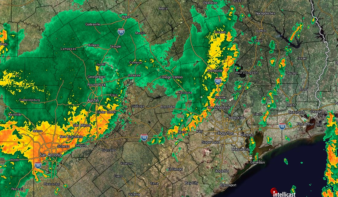
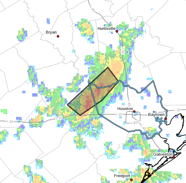
Warm Gulf to keep Texas warm this week

Good morning. Houston will remain warm this week, with high temperatures near record levels—as was the case for much of the winter. A chance of storms moves into the forecast by Friday.

Tuesday through Thursday

Expect mostly sunny days, with highs around 80 degrees near the coast and mid-80s for inland areas. Why is it so warm? Look no further than the Gulf of Mexico, where for the first time on record, the daily average surface temperature never fell below 73 degrees Fahrenheit this winter. Here’s a map showing the present-day temperature anomaly:

Gulf of Mexico temperatures remain 3 to 5 Fahrenheit degrees above normal along the Texas coast. (Weather Bell)

A steamy Gulf has meant that any time winds blow out of the south, we’re not going to cool down that much over night, and daytime temperatures can warm pretty quickly.

(An anonymous donor has sponsored Space City Weather this month)

See full post

As the Sun rises above the equator, you know what that means Houston

Good morning. Today is the spring equinox, the point at which the Sun crosses the equator. For a nice explanation of why meteorologists generally begin spring on March 1, instead of today, see this post by Braniff Davis. In practical terms, for Houston, this means that days will continue to get longer for three additional months, and we’re going to continue our march toward the dead of summer. It also makes last week’s brief cold outbreak (shown in the graphic below), all the more sweeter.

Daily temperature departure from normal in Houston this year. (Matt Lanza)

Today

It’s warmer this morning than it’s been in Houston for awhile, with lows generally having fallen only into the mid-60s. That’s because in addition to a warm flow moving in from the Gulf of Mexico, some overnight clouds helped keep some of the heat close to the surface. But those clouds should mostly go away later today and allow highs to climb to around 85 degrees (and about five degrees lower along the coast). Lows tonight will be in the mid-60s.

Tuesday and Thursday

Similar weather should continue through most of the work week—lots of sun, highs in the mid-80s, lows in the mid-60s. This is warm for mid-March, but won’t be record-setting for the area expect for perhaps the coast, where Galveston’s record highs for this time of year are around 80 degrees.

(Space City Weather is sponsored by an anonymous donor this month.)

See full post

It’s official—Texas had its warmest winter

It’s official, both Lousiana and Texas had their warmest winters on record. According to NOAA, Louisiana had an average temperatures 6.8 degrees Fahrenheit above average, and Texas was 5.7 degrees above average. From the graphic below it’s not hard to find the culprit for the warm temperatures—the Gulf of Mexico—heated at least in part due to a warming climate.

Average temperature percentiles. (NOAA)

Now let’s jump into the forecast, which will show a hint of cooler weather for next week, and a mostly pleasant Spring Break week.

Today

Temperatures are in the mid- to upper-60s this morning across Houston, and this is helping to cause some fog over the sea and for areas near the coast. It should clear by mid-morning. Skies should remain mostly cloudy during the afternoon hours, with highs climbing into the upper 70s. With the moisture now coming back and an unstable atmosphere, we’re going to be returning to a pattern where thunderstorms are possible later today, although I think most of the region will probably remain dry.

(Space City Weather is sponsored by an anonymous donor this month.)

See full post

Expect more showers Friday and Saturday before Houston clears next week

Let’s face it, Tuesday’s cool front hasn’t done a whole lot of cooling. While some parts of Houston have fallen into the upper 50s, most of the central and southern part of the region have only fallen into the low 60s. We’ll have to wait until this weekend for a somewhat stronger front.

Today

Mostly cloudy skies and an easterly wind should hold temperatures today down to about 70 degrees, but there should be no rain. Clouds and winds shifting to the southeast tonight will preclude overnight lows from falling further than into the mid-60s for all but far inland areas.

Thursday

While we can’t rule out the possibility of some scattered showers on Thursday, as moisture levels rise, it looks like most of the area will remain dry. Skies will again be mostly cloudy, with temperatures rising into the mid- to upper-70s.

Friday and Saturday

A combination of increased moisture levels, and lower pressure systems moving in from the west will lead to the likelihood of rain showers and potentially some thunderstorms on both Friday and Saturday. In terms of accumulations I don’t think the area will be looking at more than 1 to 2 inches of rain—with isolated totals a bit higher than that—during the end of the week.

NOAA rain accumulation forecast for now through Sunday morning. (Weather Bell)

See full post