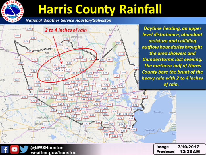
The absence of high pressure, summer-like moisture levels, and some atmospheric instability due to an upper-atmosphere disturbance led to some impressive thunderstorms on Sunday evening—what a lightning show—with the northern half of the Houston area generally receiving 1 to 4 inches of rainfall. I don’t think accumulations will be quite so high today, but we’re going to remain in this wetter-than-normal pattern into the middle of this week.
(National Weather Service)
Today
The atmosphere remains moist, and we’re already seeing some showers and thunderstorms develop over Montgomery County. Based upon these trends, rain is likely north of Interstate 10 this morning, and showers should move closer to the coast this afternoon. For the most part we’re looking at a few tenths of an inch of rainfall, but as these storms are slow-moving, some areas could pick up 1 to 2 inches over time. Highs should remain around 90 degrees. As was the case on Sunday evening, storms may well continue late into the evening.
Note: This is the second in our series of posts sponsored by Reliant. They’re covering our site for the entire 2017 Atlantic hurricane season, and in return we’re writing a handful of posts that highlight their services to readers. Today’s post concerns air conditioning efficiency and other tips to keep you (somewhat) cool this summer.
Houston has had an easy slide into summer this year, as we haven’t yet reached the upper 90s. But we all know what’s coming later in July and August, and the time to make sure your home and AC are prepared for deep summer heat is now. (Last year’s first 100-degree day came on July 23). The last thing you want is your AC to go out on the hottest day of the year.
(Reliant)
Tip #1: Be efficient
Take control of your costs by following the four-by-four principle for your AC. Set your thermostat four degrees higher when you’re away from home for more than four hours to help reduce electricity usage and costs. When your thermostat is set below 78 degrees, each degree cooler can increase your costs by up to seven percent.
Switch your ceiling fan to turn counter-clockwise during the summer months to create a wind chill effect when coupled with cool air from your AC, for a more comfortable living environment. However, remember to turn off fans when you leave the room. Fans are for people—not for rooms.
Resist the urge to override your automatic AC fan settings. Set your AC fan to the “auto” rather than “on” position. The “on” setting can increase energy costs and cause heat from the attic to transfer into your living space through the ductwork, making the AC work harder to maintain your desired temperature.
Use a programmable thermostat. It will automatically adjust the temperature to fit your schedule and conserve energy, not to mention help prevent mold that thrives in hotter, humid temperatures.
Tip #2: Change your air filters
Replacing filters regularly helps your system operate more efficiently and can prolong the life of your AC equipment. Reliant even delivers AC filters right to your door with Reliant Filters Made Easy, one less item for your checklist. Also, while changing your filters, be sure and check that you’re not obstructing the return air vents with furniture, or other items.
Tip #3: Properly insulate your home
A house without enough insulation can lose up to 40 percent of cooled air, and more than 80 percent of homes built prior to 1980 do not have enough insulation. This is the most cost-effective home improvement that can be made, as conventional insulation is relatively inexpensive.
Tip #4: Get Your HVAC Checked Out
Reliant’s home services, which are available to everyone, not just Reliant customers, to help keep you comfortable. They service air conditioning, heating (admittedly, probably not a priority right now), plumbing, electrical and more. During an AC checkup a licensed HVAC professional checks multiple points in your system, and inspects all components and parts and find out if you’re getting enough cool air to rooms.
It’s been a hot start to the month of July, with most parts of Houston seeing no rainfall. As high pressure shifts away from the area just a bit, that pattern will change over the next few days, with the return of at least some modest rain chances.
Today
A few scattered showers along the coast this morning will translate into some inland showers this afternoon along the sea breeze. For the most part, I don’t expect significant accumulations. Highs in the low- to mid-90s.
Friday
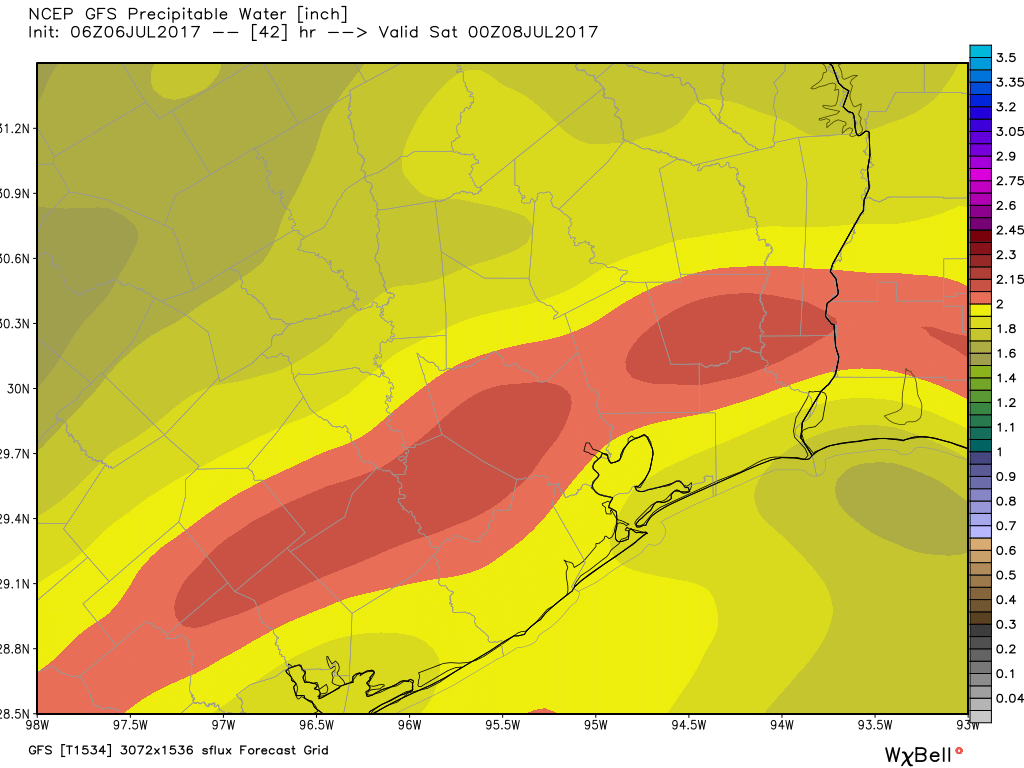
Atmospheric moisture levels appear likely to rise a bit, and this should lead to more widespread showers and thunderstorms. Don’t expect a lot of rain. While isolated thunderstorms could produce an inch of rain or so, for the most part we are talking about one or two tenths of an inch of rain. Partly cloudy skies should limit high temperatures into the low 90s.
The GFS model forecasts a good slug of moisture over Houston on Friday afternoon and evening. (Weather Bell)
Saturday through Tuesday
The mid- and upper-level winds in the atmosphere should become slightly less favorable for precipitation during this period, and therefore rain coverage will likely be only 10 to 30 percent most days, with light accumulations. For the most part days will be mostly sunny, with highs in the low- to mid-90s.
Wednesday and beyond
As we get into mid-July, some of the mid-range models suggest that high pressure will strengthen its hold on our weather. This means even hotter conditions—as we might expect during July and August—with highs in the mid- to possibly even upper-90s and mostly sunny skies. I hope that doesn’t come to pass, but it sure seems the most likely outcome at this point.
Seven of the last 10 days of June had high temperatures of 90 degrees or below—perhaps offering a false hope that summer doesn’t get so hot in Houston. Alas, July has disabused us of this notion, with highs of 94, 94, 95, and finally 96 degrees on July 4th. This is summer as we know it in Houston, and not a whole lot will change over the next week aside from some increasing rain chances.
Wednesday and Thursday
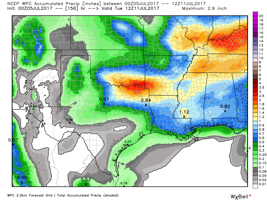
The region will see some slight rain chances today and Thursday as the boundaries between air masses collide overhead. But while moisture levels in the atmosphere are creeping back up, they’re not particularly high for this time of year so don’t expect any kind of a washout. I suspect that some areas may see a quick tenth of an inch of rain, or two, but a lot of the area won’t see any rainfall at all during the next two days. Look for highs in the mid-90s, with overnight lows in the upper-70s.
Don’t expect too much rain this week, as is borne out in this accumulation forecast. (NOAA)