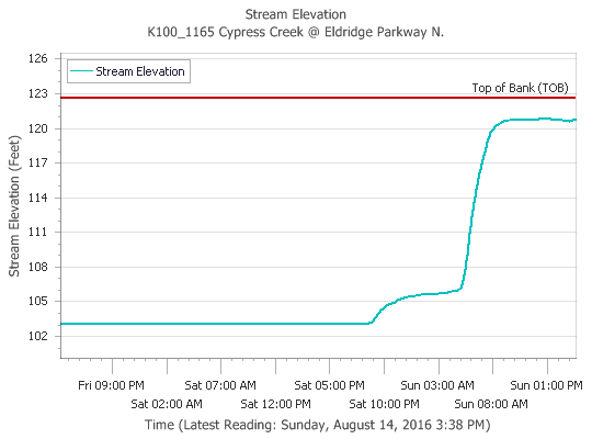
Northwest and northern Harris County have again been the focus of heavy rains this afternoon, and some areas along Cypress Creek have now received as much as 10 inches of rain during the last 24 hours. Fortunately it appears waterways in the area are remaining just within their banks.
After nearly 10 inches of rain Cypress Creek is holding. (HCOEM)
Tropical rains arrived in abundance on Saturday evening across the Houston region, proving that it only takes a matter of hours to go from near-drought like conditions to flooding. The low pressure system that flooded Louisiana on Friday and Saturday, has spread out over east Texas into a broad area of low pressure. At the same time atmospheric moisture levels are extremely high, which will allow for high hourly rainfall rates, possibly in excess of 3 inches per hour in some areas. This all adds up to the potential for ongoing and worsening flooding in Houston.
Today and Monday
The storm system has already flashed its potential this morning by dumping as much as 6 inches of rain to the northwest of Houston, near the Jersey Village area (a flash flood warning is in effect for this area). So far most bayous (including Cypress Creek and White Oak Bayou) are remaining within banks, but they have filled up quickly as the majority of the rain fell within about a three hour period. Fortunately this storm cell is now weakening, but if such an event repeats itself later today over this area, widespread flooding will likely result.
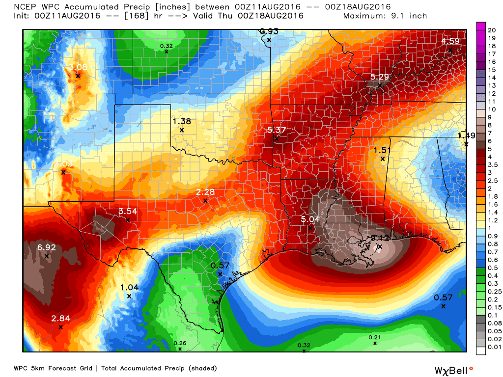
Atmospheric moisture levels are very high this morning. Anything about 2.2 inches of precipitable water is conducive for heavy rain. (Weather Bell)
The much promised pattern change in Houston’s weather is finally at hand.
During the last couple of days a tropical system has completely soaked Louisiana, leading to flash flood emergencies across parts of the state, especially for parishes just north of, and along Interstate 10. Beginning later today Houston is going to see increasing amounts of moisture from this system move into the area, which should set the stage for several wet days.
How much?
It is going to be hard to nail down the particulars of when, exactly, the heaviest rain will come. But it’s safe to say, with a tropical air mass moving into place over the region, heavy rain will be possible most days beginning later today through Thursday or Friday. Not every location will get hit every day, but we should see mostly cloudy weather on most days. After five consecutive 100-degree days, and a 99-degree mark on Friday, we should see highs confined to the upper 80s to lower 90s most days.
NOAA rainfall accumulation forecast for between Friday night and Thursday. (Weather Bell)
Houston has now had four consecutive days of 100-degree or warmer weather, and I’m afraid we’re going to have to suffer from the heat for a little bit longer before some relief arrives. But more moderate (for August) weather is indeed coming, and it should be here by the weekend.
Today and Friday
For most of the Houston area—with the exception of far eastern portions of the region—high pressure should remain more or less dominant through Friday. This means we’ll see the possibility of a few stray afternoon showers and thunderstorms, but the main story will remain heat, and lots of it. We’ll have a decent chance to hit 100 degrees both days, and low temperatures will remain pretty brutal as well, likely falling only to about 80 degrees. A heat advisory remains in effect.
Saturday
By Saturday we’ll see a transition of sorts. High pressure should weaken, and a cool front will move into northern Texas. Meanwhile, off to the east of Houston, a potent low pressure system will be bringing lots of rain to Louisiana. Houston should see some energy from the front (not particularly cool air, unfortunately) and moisture from the Louisiana system. They should combine to produce highs in the mid-90s, with a 30 to 40 percent chance of rain.
Sunday through Wednesday
By Sunday we should be in the midst of a full-blown pattern change, with highs most days in the low 90s, mostly cloudy weather and good daily rain chances. At this time it doesn’t look like the area will see any extreme rainfall, although there almost certainly will be some thunderstorms. Hopefully we just get about 1 to 3 inches across most of the region, taking the edge off of our burgeoning drought conditions.
Higher rain accumulations are more likely on the east side of Houston. (Weather Bell)