Houston has now had four consecutive days of 100-degree or warmer weather, and I’m afraid we’re going to have to suffer from the heat for a little bit longer before some relief arrives. But more moderate (for August) weather is indeed coming, and it should be here by the weekend.
Today and Friday
For most of the Houston area—with the exception of far eastern portions of the region—high pressure should remain more or less dominant through Friday. This means we’ll see the possibility of a few stray afternoon showers and thunderstorms, but the main story will remain heat, and lots of it. We’ll have a decent chance to hit 100 degrees both days, and low temperatures will remain pretty brutal as well, likely falling only to about 80 degrees. A heat advisory remains in effect.
Saturday
By Saturday we’ll see a transition of sorts. High pressure should weaken, and a cool front will move into northern Texas. Meanwhile, off to the east of Houston, a potent low pressure system will be bringing lots of rain to Louisiana. Houston should see some energy from the front (not particularly cool air, unfortunately) and moisture from the Louisiana system. They should combine to produce highs in the mid-90s, with a 30 to 40 percent chance of rain.
Sunday through Wednesday
By Sunday we should be in the midst of a full-blown pattern change, with highs most days in the low 90s, mostly cloudy weather and good daily rain chances. At this time it doesn’t look like the area will see any extreme rainfall, although there almost certainly will be some thunderstorms. Hopefully we just get about 1 to 3 inches across most of the region, taking the edge off of our burgeoning drought conditions.
In any case, it will be a nice break from a July and first nine days of August that have ranked as the region’s 4th warmest on record.
Perseids
Astronomy buffs will know that tonight marks the peak of the Perseid meteor shower, and it’s typically one of the best shows of the year. That will especially be the case tonight, thanks to a Moon that’s already set. (See more details here). The most important thing for seeing meteors is dark skies and clear skies. Houston should comply with that, as I’m expecting less than 50 percent cloud cover during the overnight hours tonight.
What’s the best time to look for the meteor shower? I’ve seen “pre-dawn hours” but was wondering if 5am is better than 6am, etc.
Best time is midnight to 4am Friday, so yes, 5am is better than 6am.
How far out do I have to go (I live NW) to get a good look at the Perseids? Would love to go somewhere “truly dark” like Enchanted Rock – but that is a tall order for mid-week.
I’d go as far as you can. Hockley/Waller is probably far enough.
If a dear colleague of mine is planning on driving his family from Houston to Orlando (through Louisiana, Mississippi, Alabama, etc.) starting this Saturday, is that a very, very bad idea? Would it be better to leave Sunday? Thank you so much for all that you do!
Sorry for the late reply. Better to leave Sunday, but the freeway should remain passable on Saturday regardless. Just go slow during heavy storms.
Hi Eric,
Just wondering, do you think the weather will remain “cool” into next weekend?
My best guess is yes.
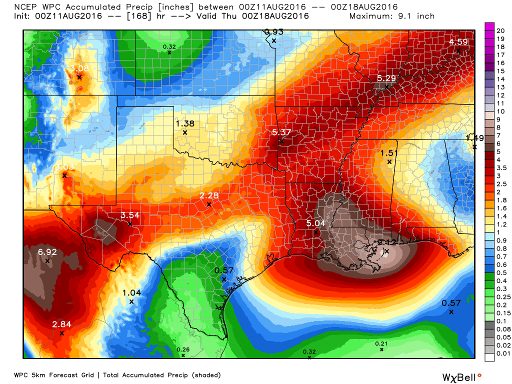
Eric, the caption in the diagram reads:
“Higher rain accumulations are more likely on the east side of Houston. (Weather Bell)”
Has forecaster thinking changed since you blogged this? Didn’t you notice that the WPC moved the slight risk for flooding a little closer to NE Houston?
I wish I’d seen this earlier on. I totally missed the perseids.
Dangit! i missed the Perseids as well. I won’t miss it next year.
Hopefully This coming summer won’t be as hot.
I’m really not looking forward to the heat this summer! No thank you!
I wish I’d seen this earlier on Eric, but this summer isn’t that bad compared to last year. Let’s look forward to July and August.
Thank you for posting this! Beautiful Pics., really interesting!