We are headed for a relatively quiet weekend in southeast Texas, after a lot of active, changeable weather lately. With the exception of a minor hiccup tomorrow, we are in for quite a stretch of weather. More in a second.
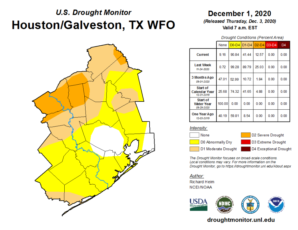
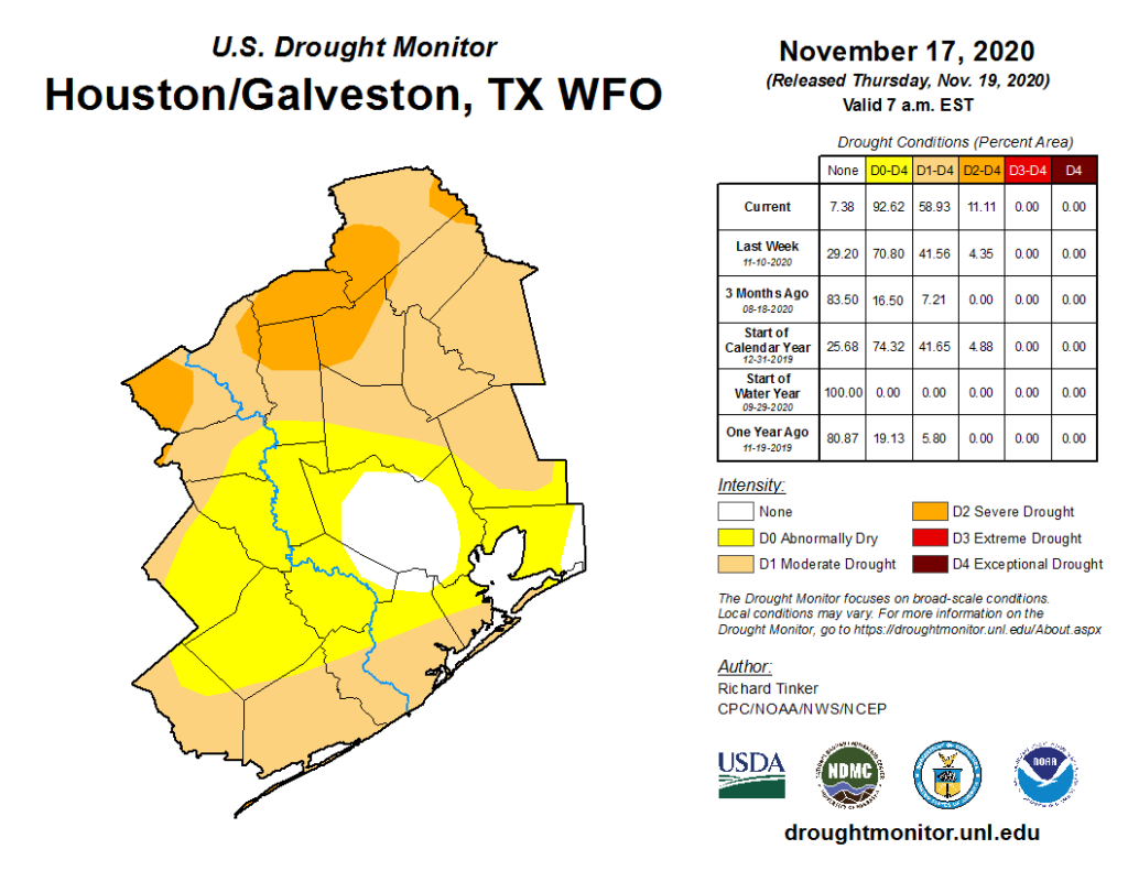
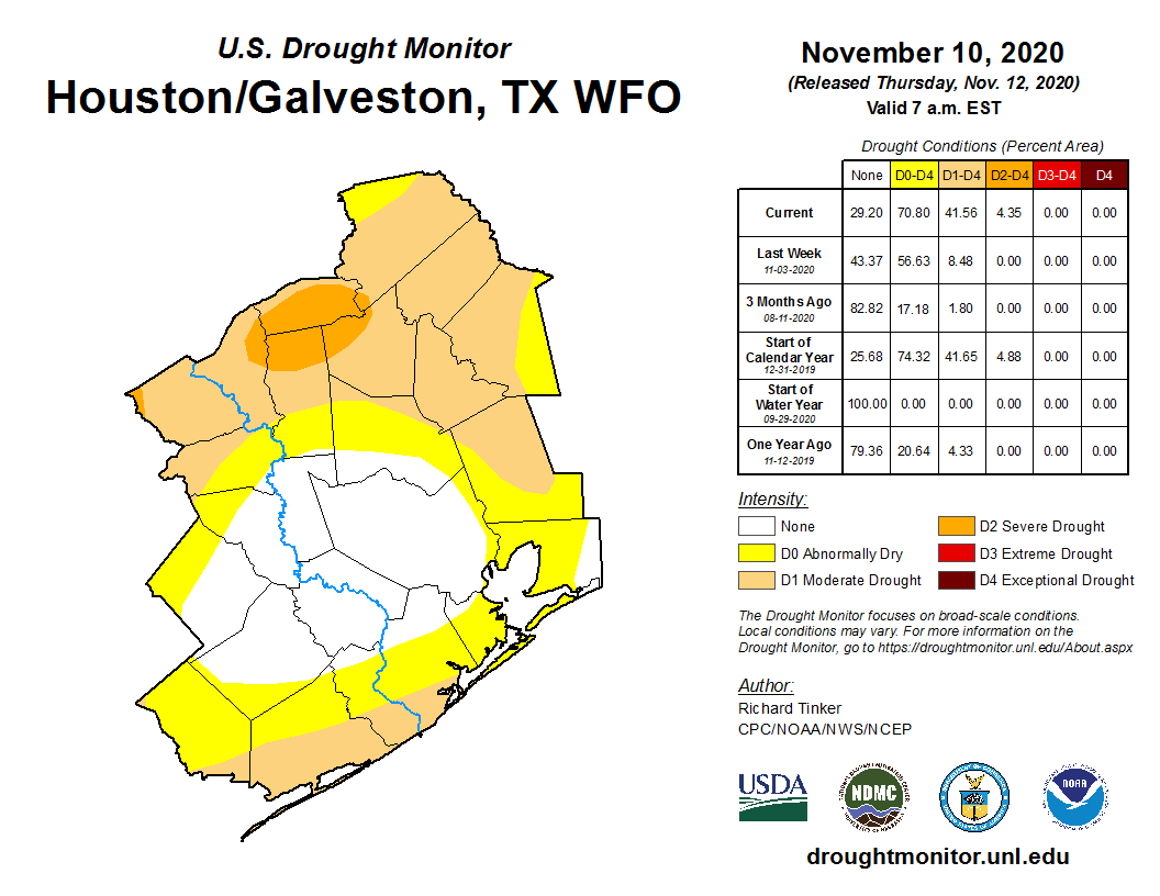
Yesterday, Eric touched on the recent rains being of benefit to our area, and the latest drought monitor update certainly highlights this. The Houston region saw drought coverage drop from near 90 percent a week ago to only 41 percent this week.
The rains of the last week or so have put a major dent in drought in the Houston region, and this doesn’t even include Wednesday’s rain. (Drought Monitor)
And in reality, it’s actually even lower than that, as the rains from Wednesday were not included in this update. So look for drought conditions to minimize even a bit more next week. We can stop discussing drought for awhile now.
Today
Look for sunshine for much of today. There will likely be some high clouds passing through at times, but it should not be much worse than that. We will see highs in the 50s with a bit less wind than yesterday.
Weekend
A more robust area of high clouds will overspread the area tonight. We’ll call it mainly clear, but by sunrise tomorrow, it could be partly to mostly cloudy. Moisture gradually increases tomorrow, and we will likely see some light rain or passing showers break out, particularly south of I-10. We’ll probably see a good setup for “virga” later tomorrow and tomorrow night as well, rain falling aloft but evaporating before it hits the ground. We’ve got enough moisture aloft, but dry air will still be attempting to win out at the surface. So if you check radar this weekend, it may look worse than what reality is on the ground.
Moisture begins to thin out on Sunday, which means we should see mostly sunny skies develop.
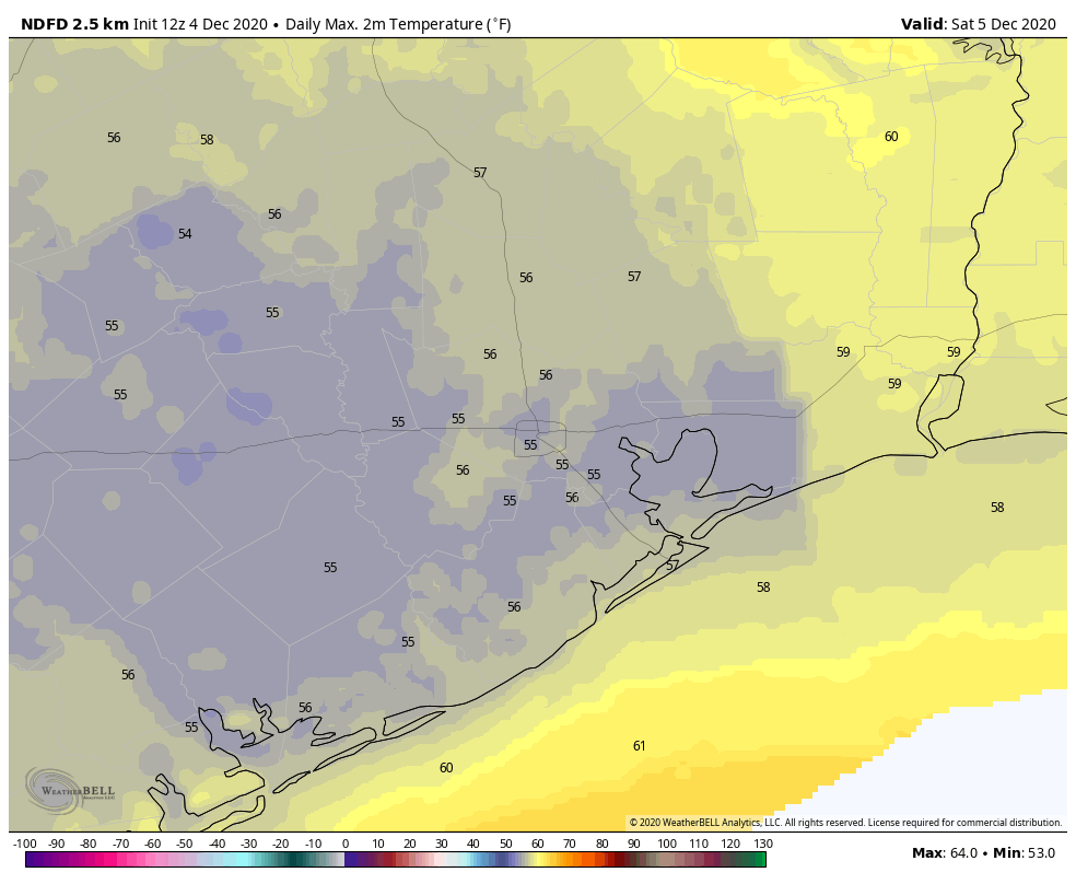
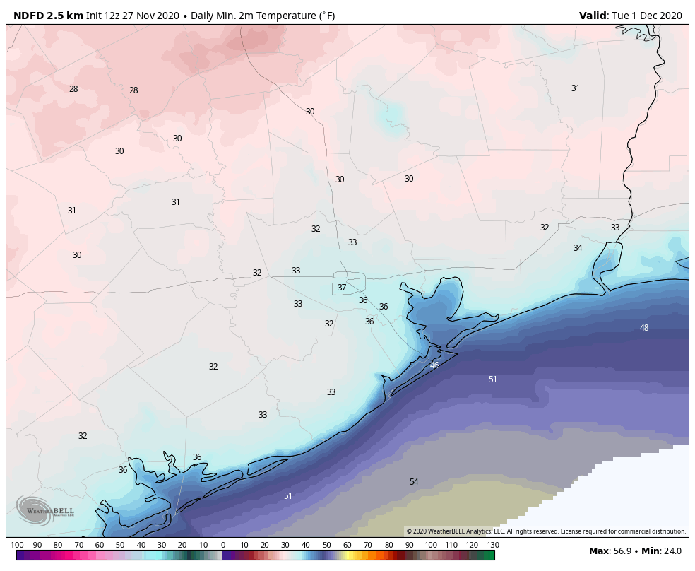
Look for lows in the 40s in the city and at the coast Saturday morning, with 30s in outlying areas. Highs on Saturday will struggle a bit due to cloud cover and may limp into the 50s in spots.
Depending on how much cloud cover we see tomorrow, high temperatures may just barely reach the mid-50s. (NWS forecast via Weather Bell)
Clouds will keep lows in the 40s in most spots on Sunday morning, followed up by a nice afternoon with highs near 60 degrees.
Early next week: Glorious
Monday and Tuesday look sunny and rather pleasant. Expect highs near 60 degrees on Monday and perhaps a few degrees warmer on Tuesday. Lows should be in the upper-30s or 40s. Wednesday looks good as well right now. There may be a dry front that reinforces cooler, drier air over us Tuesday or early Wednesday, and that would also reinforce sunshine.
When the nice winter weather hits Houston… (3Below: Tales of Arcadia)
To be honest, at this point, Monday through Wednesday of next week will be cool days, but they may be some of the nicest you could ask for in winter in Houston.
Later next week
Onshore flow finally kicks back in on Thursday or Friday, which should allow for clouds and warmer temperatures to come back. We may also see some morning fog. Our next storm system should arrive around this time, bringing a chance of rain probably focused on next weekend. Our next front will probably follow at some point Sunday or Monday. More on that next week. Enjoy the weekend!
A lot to get to today, but I want to start by saying that I hope everyone’s Thanksgiving was as enjoyable and, most importantly, safe as possible. It’s been a rough year, and I hope you were able to find some time to be at peace with everything. I’ll echo Eric’s sentiments from yesterday and say I am grateful for your trust and loyalty. It’s a honor to be of service and to be able to work with a fine partner like Eric. Thank you to all!
Let’s kick today off with a quick bullet point summary of what’s happening here.
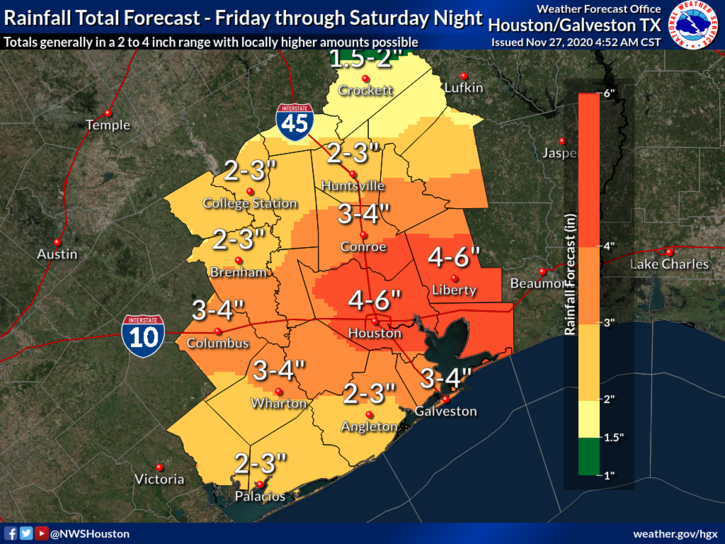
Multiple rounds of rain will move through the area today and tomorrow, ending on Sunday morning, totaling 2 to 4 inches on average with amounts of 4 to 6 inches or even a bit more in spots.
Localized street flooding will be the biggest concern, as the dry ground should be able to absorb most of what falls. No flood watches are in effect as of Friday morning.
Some storms could be strong to severe with gusty winds or hail on Friday, but heavy rain remains the biggest impact expected from this event.
Much cooler, drier weather will follow on Sunday and early next week.
Today and tonight
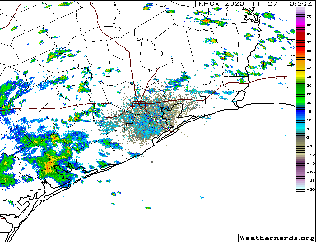
Heavy rain has already begun to move into the area this morning as an area of low pressure, a couple fronts, and a favorable atmosphere above combine for a healthy rainfall setup.
Robust rainfall has already started to move across the western and northern halves of the Houston region this morning. This will continue off and on through the day. (Weathernerds.org)
Expect the rain to come in waves today, pouring for a while, perhaps dry for a chunk of time as well. Rain totals should add up to about an inch or two on average, but there will likely be a couple areas that see as much as 3 to 4 inches of rain just today. In addition to heavy rainfall, today’s storms may be capable of producing some small hail or strong, gusty winds. A widespread severe weather outbreak is not expected, however.
Look for temperatures in the 70s today, easing into the 60s this evening. Rainfall will probably become a bit more intermittent this evening and overnight, though we probably never actually dry out completely.
Saturday & Sunday
A strong upper level storm system will sweep into the region tomorrow, initiating another round of off and on rain and thunderstorms. Rains will again be heavy at times through the day and into tomorrow evening. The severe weather threat tomorrow is fairly low, so that’s not a serious concern. Another inch or two of rain, with locally higher amounts will be possible before things calm down tomorrow night and Sunday morning.
When all is said and done, between the rains Friday and Saturday, we expect about 2 to 4 inches of rainfall on average, with areas of 4 to 6 inches likely. A couple smaller areas could see amounts as high as 6 to 8 inches.
Total rainfall of 2 to 4 inches on average with areas of 4 to 6 inches are likely. A couple smaller locations could even see as much as 6 to 8 inches before all is said and done. (NOAA)
In terms of flooding, given the dry weather of late (see below), we can actually absorb most of this rain. There are no flood watches posted in our area as of Friday morning, and we will not be issuing any SCW Flood Scale guidance for this either. That said, if we were to have to escalate things, it would most likely be to Stage 1 and probably not much worse. This rain should be more beneficial than problematic overall.
The rain ends sometime in the predawn hours or early morning on Sunday, as a cold front sweeps through. Look for winds to crank up behind the front, with northerly or northwesterly winds of 15 to 25 mph, and higher gusts over the bays and Gulf.
Temperatures will spend much of Saturday in the 60s before cooling to near 50 on Sunday morning (cooler north and west perhaps). Sunday afternoon will see gradual clearing and eventually sunshine with highs only in the upper-50s.
Next week
Monday should still be breezy and chilly. Look for morning lows to start off in the low to mid-40s in Houston and probably 30s in some outlying areas. We’ll warm into the mid-50s with plentiful sunshine. Tuesday will be the chilly morning, with lows in the 30s most everywhere away from the immediate coast. There will be risk of a light freeze north & west of Houston; basically north of I-10 and west of US-59/I-69.
Tuesday morning will probably be the coldest of the season so far. Freezing temperatures are possible west and north of Houston. (Weather Bell)
Tuesday afternoon should again feature plenty of sunshine with highs in the upper-50s to perhaps near 60 degrees. Our next front arrives on Wednesday or early Thursday it would appear, which should setup another round of chilly, fair weather into next weekend. There are still questions as to how much rain we can expect with that next front, but it likely won’t be as drawn out as this weekend’s event.
Drought dented
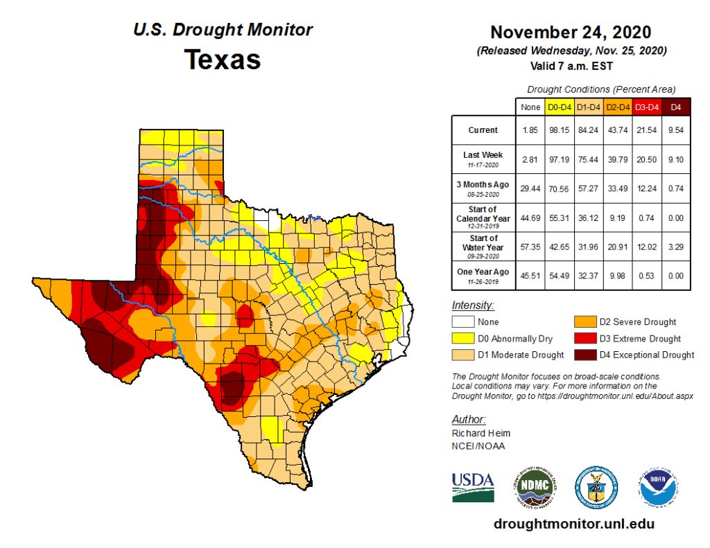
The good news with all this rain for the region is that it’s occurring just in time, likely again saving us from a true drought for the time being. This will be at least the third or fourth time since late spring that we’ve had a significant rain event arrive just as it appeared we were headed into drought. Yesterday’s drought monitor update had 84 percent of Texas in drought, up from 75 percent a week ago.
Drought covers 84% of Texas this week, including most areas surrounding Harris County. Our rainfall this weekend will dent this considerably. (Drought Monitor)
Drought has finally entered the outskirts of Harris County, and is widespread in surrounding counties. We should now be able to take a fairly lengthy break from discussing drought after this weekend. Only 2 weeks ago it appeared we had nothing in the pipeline, so it’s always interesting how a few changing pieces can change the whole storyline.
We’ll keep you posted this weekend if anything changes or if rainfall becomes more serious than we believe it will be right now. Otherwise, enjoy and stay safe.
Good morning! Right out of the gate, we are experiencing some dense fog this morning all over the place away from the coast. If you’re out and about through about 9 or 10 AM, please use caution. Conditions should improve after that. More below.
Drought update
As I have the last couple Fridays, I’m going to talk about drought this week, and in fact, I’m going to lead with drought.
Drought will continue to gradually expand across Texas. While it is not a huge issue for us now, that could change in the weeks ahead. (US Drought Monitor)
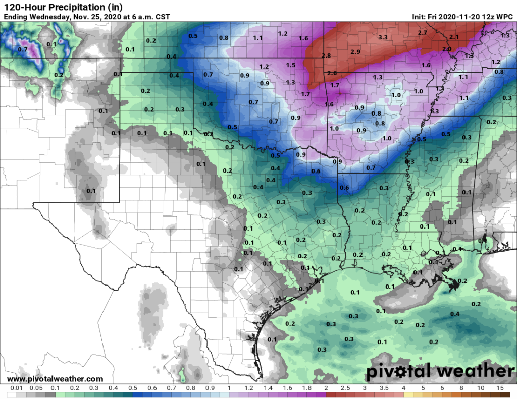
The Houston region (the footprint of the National Weather Service forecast office, at least) has seen drought expand from about 42 percent of the region last week to 59 percent this week. Severe drought covered a little over 4 percent of the region last week, and has since expanded to cover about 11 percent this week. Most of that is in the Brazos Valley or north of there. Harris County is just now emerging in “abnormally dry,” the precursor to a true drought. Outlying areas are already there. Texas as a whole has seen drought expand over about three-quarters of the state. The question now becomes how bad does it get? That’s a tough one to answer. Over the next 5 days at least (which gets us to the end of the next drought monitor update), we will see scant rainfall.
Expected rainfall through next Tuesday night doesn’t look very impressive at all. (NOAA forecast via Pivotal Weather)
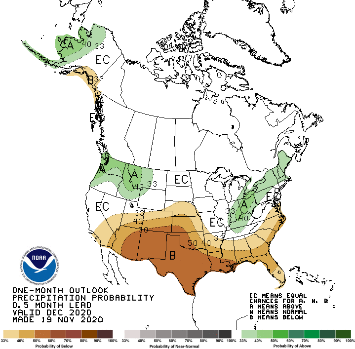
Beyond that? Well, the National Weather Service isn’t exactly optimistic. Their 30 day outlook released yesterday calls for a better than 50 percent chance of below average rainfall. That means drier than normal weather is expected to persist into December.
NOAA’s 30 day rainfall outlook is showing fairly high confidence of below average rainfall continuing into December. (NOAA)
That does not necessarily mean we’re heading for a serious drought, but here’s a statistic. We are in a La Niña event right now, meaning the waters of the tropical Pacific are running cooler than normal. Using the Oceanic Niño Index and filtering for winters that saw at least 2 periods at or below -1 between November and March (indicative of what I would classify as a firmly moderate La Niña event), we can compare rainfall averages. In a normal December through March, Houston officially receives 13.73″ of rainfall on average. In just those La Niña years since 1980, we’ve averaged 11.92″ of rainfall. So there is a definite skew toward a drier than normal winter. If we can be bailed out every now and again by a rain event, that goes a long way toward mitigating drought a bit. Over the next 3 to 4 weeks at least, that does not seem likely, however. We’ll see.
On to the shorter-term forecast.
Today through Sunday
Again, just watch for fog this morning. Once the fog lifts, expect a mix of clouds and sun the rest of today. I do expect a few showers around the area, none too serious, but just don’t be shocked to see some minor rain. Highs will be close to 80 degrees this afternoon.
More fog is possible tonight with lows in the 60s. Look for a mix of clouds and sun otherwise on Saturday, another very slight chance for a shower, and highs near 80 degrees.
Sunday should be more of the same, although fog risk may be just a little lower in the morning: Lows in the 60s and highs in the upper-70s or low-80s.
Monday front & Tuesday
A cold front is aiming to slice through the region on Monday. There honestly does not appear to be much to this front, either rain-wise or “cold” wise. We should see sunshine develop for Monday with slightly lower humidity. Expect highs in the 70s with morning lows in the 50s. We’ll get another slightly cooler night Monday night, followed up by quick return to warmer temperatures Tuesday, along with a slight shower chance. Highs on Tuesday should bounce back close to 80 degrees.
Beyond Tuesday
The weather pattern that we’re in is one that features a very quick moving, mostly low-amplitude jet stream. This means we will see continued cold fronts but probably not a lot of truly cold air. Basically, what I would call Goldilocks weather with a touch of humidity at times.
You can see the impact of the fronts through Wednesday mainly reflected in nighttime low temperatures, which cool just a bit each time a front passes. Another, slightly stronger front is likely next weekend. (NWS forecast via Weather Bell)
Models continue to point toward another front on Wednesday that, as Eric has noted this week, would usher in pleasant weather for Thanksgiving Day. We will stick to that again today. However, it does look like we will quickly warm up on Friday before yet another front arrives next weekend. That front could have a little oomph behind it, although despite all these fronts, right now it seems that we will see relatively little rainfall. And so it goes.
Fundraiser
I just want to again thank our readers for their support during our fundraiser. There’s still some time left if you want to grab some Space City Weather swag. We sincerely appreciate your support, both now and year-round! It truly means so much to us.
Before I get into the weather, I really just want to say how floored Eric and I both are by the support you’ve shown us as we kicked off our annual fundraiser this week. We are truly humbled, and we cannot thank you enough.
Jumping into the weather, it’s pretty benign around here, and it looks to stay that way into next week, though with some changes that we’ve discussed through the week.
Today
After tying a record high temperature yesterday (85°), we’re likely to end up in a similar spot today, with low to mid-80s for afternoon highs. Today’s record is 86°, and we’ll see if we can make a run for that. We’ve got some lingering fog this morning that should dissipate by mid-morning or so. We will at least mention the chance of a shower, mainly south and west of Houston. It would seem that Brazoria, Fort Bend, and Austin Counties (and points southwest of there) stand the best chance at seeing some raindrops this afternoon, but don’t be entirely shocked to see some brief rain anywhere.
Saturday
After a mild, muggy morning with lows in the 60s, look for a mix of sun & clouds tomorrow, with highs once more in the mid-80s. The record high tomorrow is 89°, which should be safe. I wouldn’t entirely rule out a few passing showers tomorrow, though they would be the exception, not the rule. Onshore winds could gust close to 20 mph or so over Galveston Bay on Saturday afternoon.
Sunday morning’s low temperatures are going to feel more like early autumn, with some places struggling to get below 70°. (NOAA forecast via Weather Bell)
With building humidity, look for a warm, muggy night for November. Lows may not dip below 70° in some spots tomorrow night.
Sunday
The challenge with Sunday’s forecast will be timing the cold front. Model forecasts have sped up some since yesterday, with most models bringing the front through during the mid-morning hours. The good news from a forecast standpoint is that what you experience on Sunday should be mostly the same regardless. Look for the muggy, warm morning noted above to continue. We’ll see clouds and some sun. Highs on Sunday should manage to get to about 80° (perhaps only upper-70s in some spots with a faster front), but with the front coming through sometime in the morning, it will feel a lot more comfortable by afternoon. The front itself may carry a narrow line of showers which would be unlikely to amount to much more than a tenth of an inch or so of accumulation. We’ll see clearing skies Sunday afternoon & evening, along with a modest offshore breeze, perhaps gusting close to 20 mph over the bays.
Next week
Monday and Tuesday will feature chamber of commerce weather. Look for sunshine, low humidity, highs in the mid-70s, and lows in the 50s, with perhaps even some 40s in outlying areas on Tuesday morning.
Tuesday morning low temperatures will be cool, with 40s possible in outlying areas. (NOAA forecast via Weather Bell)
Look for onshore flow to return by midweek, and after a nice Wednesday, we’ll see humidity rev up a bit closer to the weekend. It’s also possible we are talking 80s again by next weekend. And barely any chance of rain. Speaking of…
Drought
Last week’s drought monitor report had about 8.5 percent of the Houston region classified in drought. That has ballooned to over 40 percent this week.
Drought has expanded to about 40% of the Houston region, and it will not get any better over the next week or two. (Drought Monitor)
While Harris County is not in drought at this point, we are basically surrounded, including even a pocket of “severe” drought over Grimes, Walker, Madison, and Brazos Counties to our north. If you’re curious about the rest of the state, nearly 60 percent of Texas is classified as in drought, with about 20 percent (mainly in far west Texas) in extreme or exceptional drought. Droughts are one of the worst types of weather events to communicate because they can wreak havoc and are usually painfully slow to evolve. It’s pretty obvious right now though: We are seeing drought expand, we have little hope for meaningful rain over the next 10 days, and we are firmly in a La Niña, which is often a harbinger of a dry winter in the South. I know we have some farmers and other folks sensitive to drought that follow us. We are not yet ringing the alarm bells on a severe, long-duration drought for the region, but we are telling you that the players are trying to line up on the field. We’ll keep you posted.
Tropics
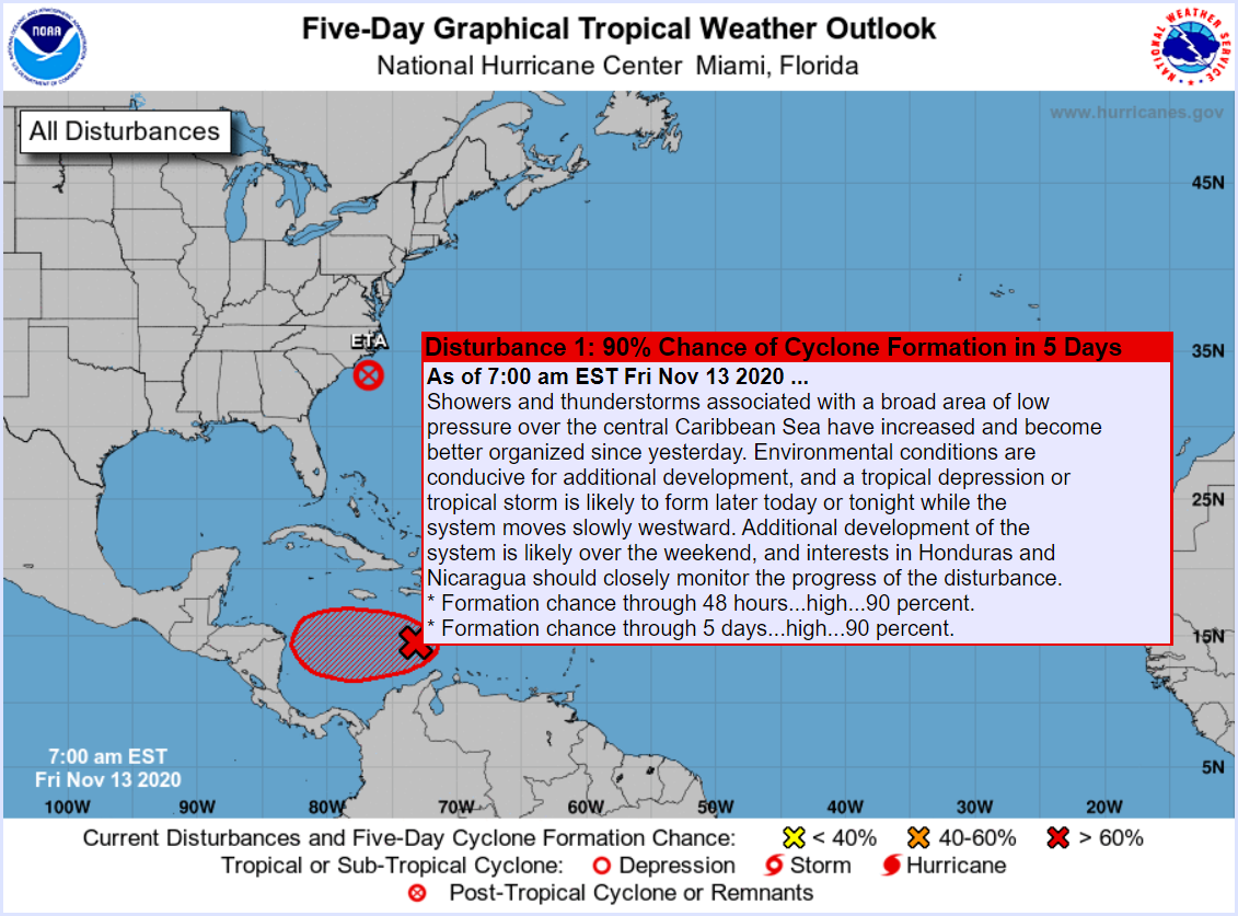
I just want to close with a quick note on the tropics. Invest 98L, the area tagged by the National Hurricane Center with a 90 percent chance of development is likely to become a depression or Tropical Storm Iota today or tomorrow in the Caribbean.
We are likely to see a Hurricane Iota in the Caribbean by Sunday or Monday. It’s not a threat to the Gulf, but it will likely impact areas in Central America that were just severely impacted by Hurricane Eta. (NOAA)
While it won’t be a threat to the Gulf, there is a chance that this one again rapidly intensifies and slams into Central America, not far from where Eta just hit, further cementing 2020’s status as an infamous hurricane season.