Last night was quite active in parts of the area. In other parts of the area? Yeah, it felt like a flop.
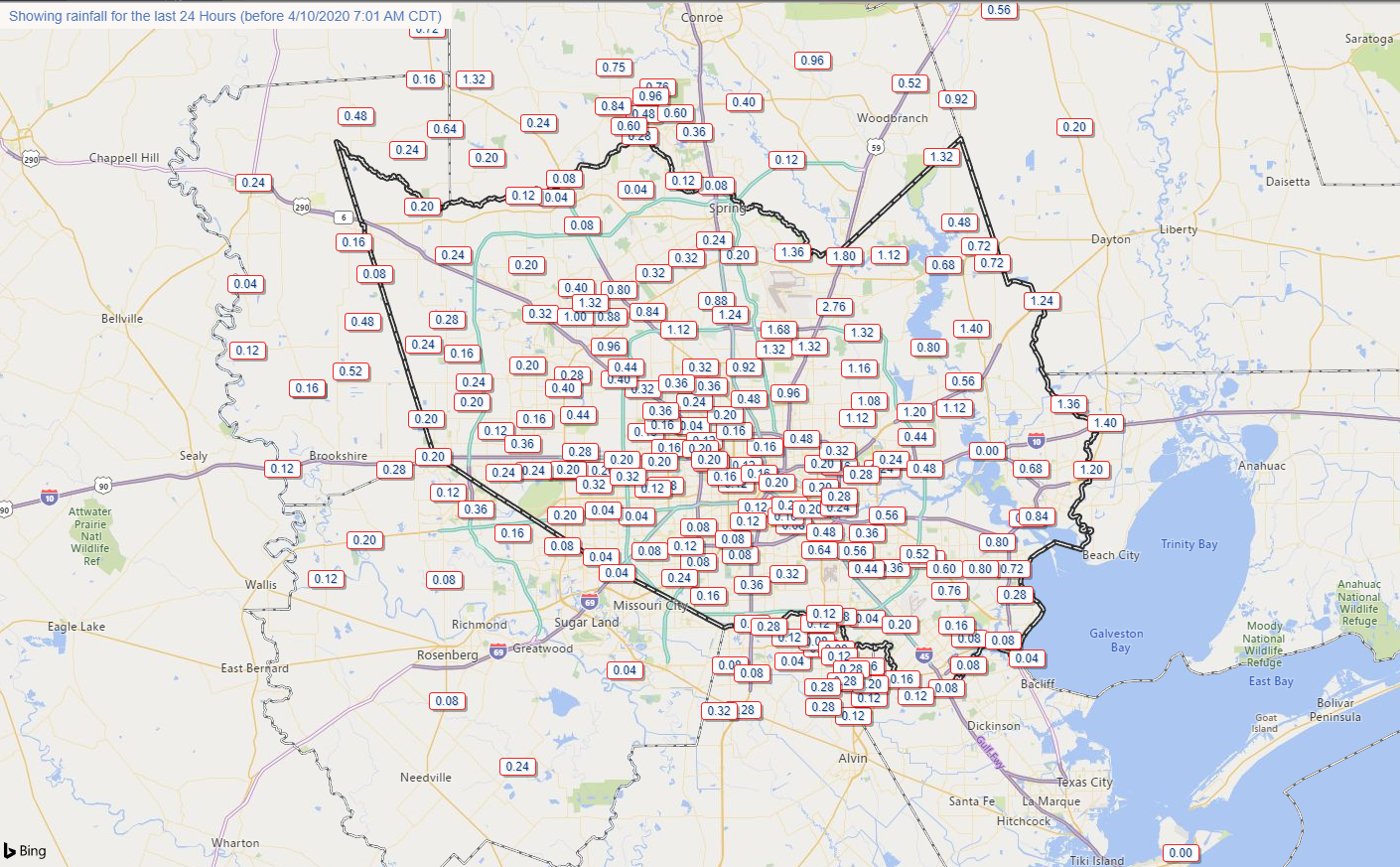
Rain totals were quite erratic. Southern areas saw low amounts. Northern areas saw variable amounts. A gage just east of IAH Airport between Will Clayton Parkway and the Beltway along Garners Bayou nearly received 3″ of rain. But that was very much the exception yesterday. Rain totals elsewhere were less than a quarter inch in many places like Tomball, Cypress, Katy, and Sugar Land. The Woodlands saw a pretty good storm, but even there, it moved fast enough that rain totals were generally under an inch.
Severe weather was not really an issue in the Houston area either. Most reports yesterday came from the Brazos Valley and back west toward Austin and even those were few.
Anyway, with that in the rear-view mirror, we can start talking about the next round.
Today
First off, today looks quiet. We will have clouds for the bulk of the day, but it will feel refreshing after yesterday’s record heat (91° at Hobby was a new record, 91° at Bush fell a degree short). Look for highs mostly in the 70s today. It will also be a good bit breezy at times with winds out of the east or northeast around 15 mph with higher gusts, especially over the bays and Gulf.
Saturday through Sunday morning
For Saturday, morning, lows will be in the low-60s or even upper-50s, but temperatures will rebound into the middle 70s through the day. An approaching warm front will send humidity up through the day as well.
The biggest question on Saturday revolves around rain and thunderstorms. Let’s work through this in order of likely outcomes. Scattered showers are likely Saturday morning and afternoon. Many of us may not see rain, but some of us will. Models differ in opinion on where rain will arrive, with a couple suggesting coastal areas and Houston will see a good deal of showers tomorrow morning. Others keep those areas mainly dry and focus development off to the north and west of Houston. We will call it scattered showers and go from there. A thunderstorm is also a good possibility too. For the most part, we do not expect significant severe weather Saturday morning or afternoon in Houston.
Severe weather on Saturday afternoon will probably begin in Hill Country or west of San Antonio toward Del Rio and the Rio Grande Valley.
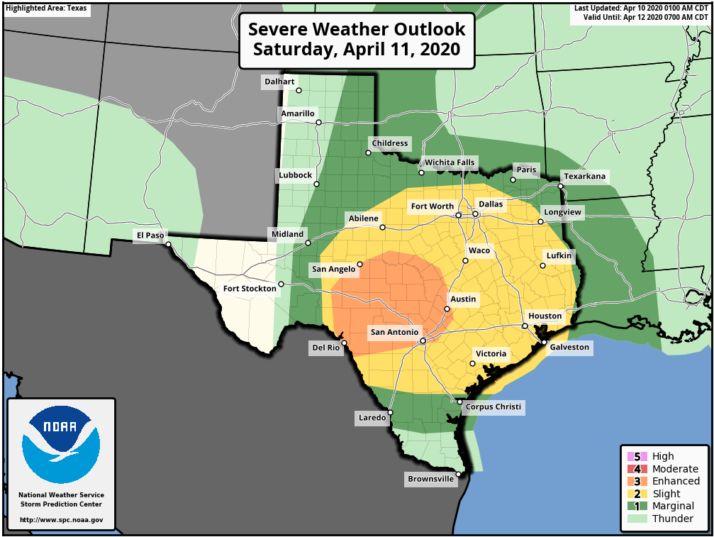
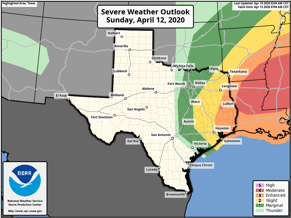
Heading into Saturday night, with a warm front in the neighborhood and ample moisture in place with a strong disturbance approaching, that’s typically a recipe for thunderstorms to develop. There are still a lot of questions as to exactly how Saturday night is going to play out. There should be strong to severe thunderstorms in Central Texas moving into East Texas, especially north of I-10. We could see additional development of storms ahead of that off the Gulf. At this time, that looks more concerning east of the Houston area, more into Louisiana. But with a good bit of uncertainty still in play and a Sunday severe weather outlook that is still pretty aggressive nearby, I don’t want to rule anything out at this point.
Bottom line on Saturday night/Sunday early morning: Expect showers and potential for some thunderstorms. Some severe weather is possible, but odds may be highest north and east of Downtown Houston. Eric or myself will keep you posted this weekend if things get more serious.
There will be a couple boundaries pushing through Houston on Sunday. The boundary with storms should push out, ending the rain by 10-11 AM or so. The first cold front will follow around 12-2 PM or so. That will flip winds out of the west, and they should increase as well back to the 15 to 20 mph range, with higher gusts.

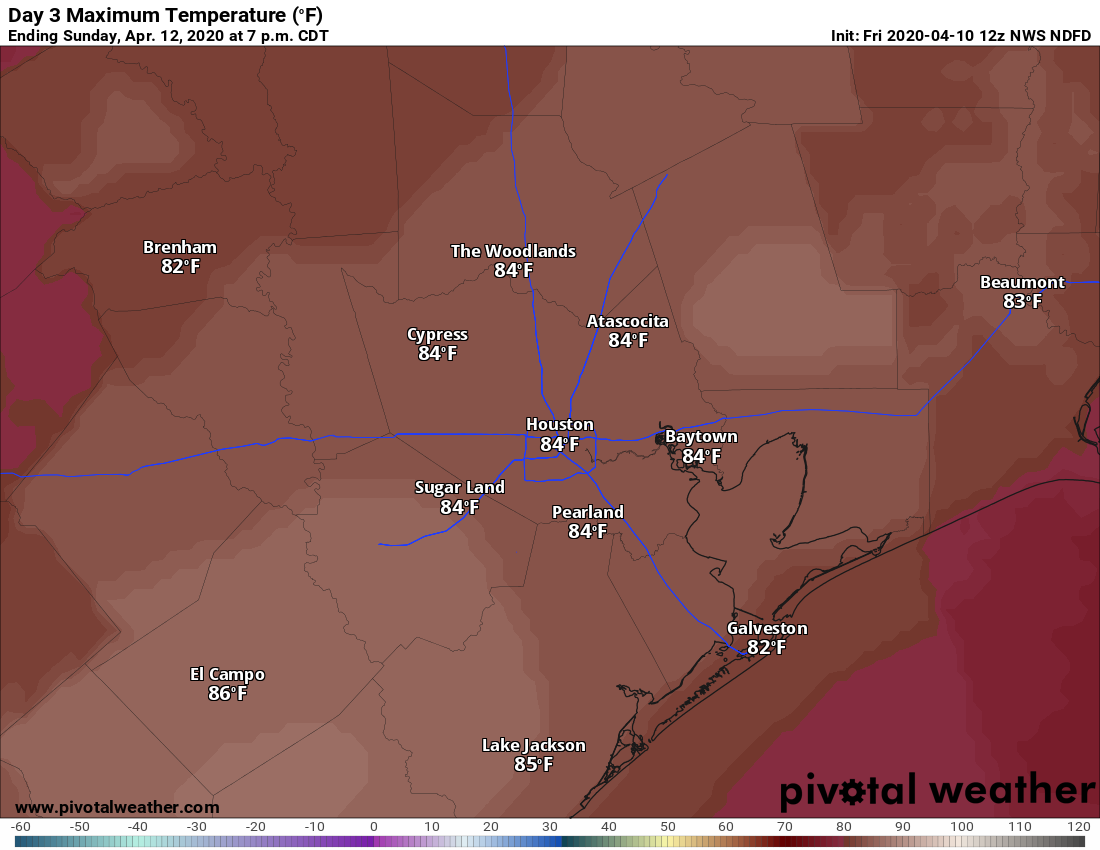
Clouds will rapidly clear out in early afternoon, and it will become sunny. Can it be hotter behind a cold front? Yes. In fact, in this case, with humidity plummeting Sunday afternoon, this will allow the atmosphere to heat up more efficiently (dry air heats up easier than humid air), and we could see temperatures soar into the mid-80s Sunday afternoon.
That’ll be the last of the heat for a little while.
Monday
Another front will arrive in the pre-dawn hours Monday. It should be a dry frontal passage. This one will allow for more substantial cooler air to build into the region. So by Monday morning, we should be in the 50s in most of the area. With gusty north winds on Monday, look for highs to struggle to get to 70° and potentially not even make it there.
Rest of next week
Could we see lows in the 40s next week? If we do, pencil in Tuesday or Wednesday morning on your calendar. Currently, the National Weather Service has upper-40s in Houston on both days (Wednesday is shown below).
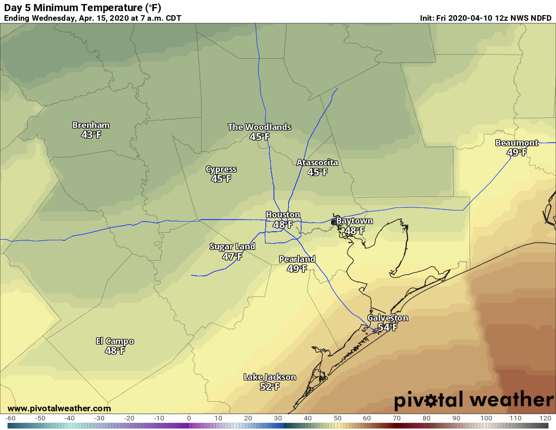
But there is little difference in how 52° or 48° feels, so either way, look for some really refreshing mornings next week. Our days will be filled with mostly sunshine, just a few high clouds, and highs in the upper-60s to low-70s Tuesday and Wednesday. We’ll begin to warm again Thursday and perhaps Friday.
Total flop in League City last night 🙁 I kept watching the radar starting at about 5pm and all I saw was the storm line moving further and further north 🙁
In the Woodlands around 6 pm, the wind kicked up and heavy rain started pouring down while I was on my way to grocery pickup – Within 15 min it had moved on. It was really strange.
Some really strong winds yesterday afternoon/early evening. Later on got some good rain, nothing severe. Sounds like Monday and Tuesday will be the Easter spell. From there it will warm up and just keep getting hotter and stay hot until November.
I have wondered for a long time: why does severe weather often go “north of I 10” and miss central Houston?
Our location lends itself to being “capped” a lot in the atmosphere. So a weak area of warming temps as you go up in the atmosphere effectively creates a lid on how tall cloud tops can grow. So if clouds and convection are suppressed, you end up with less storminess. The cap is an issue farther to the north, but it’s a little easier to break the cap up there, I think because a.) of their proximity to large scale storm tracks (like low pressure systems) which can erode the cap efficiently. And b.) I think also their distance from the Gulf helps too. They still often have issues generating storms in certain setups, but they have a few more ways to get storms going than we have here.
Matt, does urban heat island effect contribute to capping in any way?
Good question, and honestly one I don’t know much about. My hunch is that no, it wouldn’t since an urban heat island effect would probably be more localized, but I can’t tell you I’m certain of that.
Do you have any thoughts or commentary on why yesterday was such a bust? Back on Wednesday, there were dire predictions of widespread golf ball size hail and I was coming up with ideas of how to cover the one car that I don’t have a garage spot for. Seems like we got a bit of wind down here around Manvel, but by the time I checked my weather station this morning, I managed less than 1/8″ altogether of rain.
I washed my car Wednesday morning, immediately saw all the weather warnings for heavy rain (always happens after I wash my car). Then I heard about the hail, so I spent half of Thursday clearing out enough room in my garage to park the car inside. Naturally, nothing happened. Nature seems content to make me waste my time in either case.
So, I don’t think anyone was predicting “widespread golf ball size hail.” Everyone said there was that potential (which there was), but not that it would be widespread. And on Wednesday, Eric classified the chance of hail as “possible.” So. Not quite sure where that impression came from. Yesterday busted in the southern half of the metro area probably because the forward motion of the storms was so quick. We had storms racing north of I-10 that were very well organized from east of Austin through College Station into northern Harris and Montgomery Counties. My guess as to what happened was either we had a weak “cap” in the atmosphere here that kept the intensity of storms in check in Houston and toward the Gulf. Or we just had rain cooled air from the storms racing to our north that snuck down and eviscerated what had been very high instability over the Houston area. But the storms moved faster than I expected yesterday AM and I think faster than most models predicted which probably played a role in keeping the whole system disjointed and less organized in terms of severe weather.
Well, to be fair, it may have not been here, but this it what greeted me in my feed yesterday morning, with indications that the hail would likely be golf ball sized. Sure looks like a wide spread prediction to me.
https://imgur.com/W2hEX5t
Ah yes. So they are showing the SPC risk for severe hail. That graphic is tough to interpret because, yes, it looks like everyone is doomed. That graphic is just saying that there is a 30-45% chance that 1″ or higher hail will be observed within 25 miles of any given point in those areas. The hatching means that there’s a 10% probability of 2″ or higher hail within 25 miles of a given point in the highlighted area. So if one location observes 1-2″ hail in that entire highlighted area, the forecast technically is a hit. It’s a lot less straightforward and much more nuanced than the graphic itself suggests. In my own humble opinion, I wish people wouldn’t show that graphic without that context clearly labeled. Even then, it’s not easy to necessarily interpret.
My confidence in the SPC lowered another notch. Not even a thunderclap. I’ll read you guys forecast but I’m giving everything else the weekend off. Better luck next time SPC.
Huntsville lost power for the entire night and knocked many trees over. Just because you didn’t get any severe weather doesn’t mean nobody did.
I didn’t say nobody got hit. I was talking about my area. I’m sorry for your area and everybody else that was affected. I’ve noticed quite a few snide remarks on this page. I’ll do my best to stay off of it. Very sorry I offended you.
Yeah, it was quite an impressive storm on Lake Conroe – monumental!
I can’t emphasize this enough: SPC are the absolute best in the field at this stuff. They are an exemplary organization. They are not perfect, but you will not get a much better severe weather outlook from anywhere else. I’ve interacted with a lot of people in the field of forecast meteorology, and I can tell you that the SPC folks are far and away the smartest people and best forecasters out there. And I honestly don’t think it’s even close.
I know they are Matt. It just seems their batting average is a little low for us lately. They’re very good at what they do which isn’t the easiest job around.
Here in Huntsville, we had trees down all over and have been out of power since 5pm yesterday. Not expected back on until 6pm today.
In Spring we had winds that knocked out the power for a few hours.
It was a crazy strong storm on lake conroe. Trees down and too much lightening!!
Matt, You mentioned “higher wind gusts, especially over bays and the gulf” for today. Often the case but why is that ?
In case Matt can’t get to you: Basically, air accelerates over water due to lower friction and less impediments to its motion.
Yes.
So, my little town of La Porte sent out a message about severe weather heading our way. It mentioned very high winds, hail, and heavy, thunderous rain. The notice was put out in the late morning hours. So, I waited, and I waited and I waited. Finally, around 7 PM it got really dark, then a good breeze picked up, then it rained like crazy for about three minutes. And, it was over, done, fini, kaput. Talk about a bust…… But, at least I don’t have to water my new plants! 🙂
People commenting here and on twitter disappointed that strong and possible damaging storms weren’t as widespread? Come on people
Oh, I’m not disappointed that we didn’t get hail. I’m just curious why the models were so wrong on this one.
Yeah. I’m curious on that too. Went and did some preparations for my parents and had to be near them when I’d rather keep distance.(dad is elderly and immunocompromised)