We saw a few showers in the area on Thursday, but for the most part it was a much calmer day than Wednesday. Some folks in our area have been bypassed by these showers more often than not lately, and it’s beginning to add up across much of Texas.
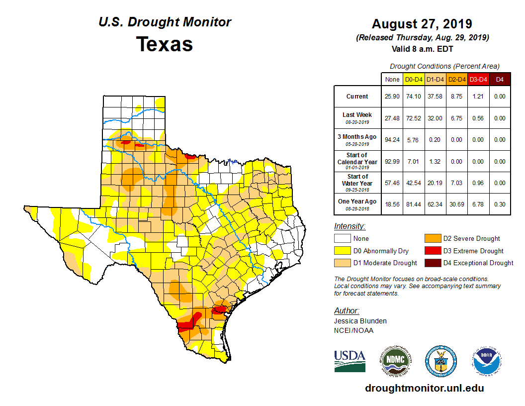
Drought is beginning to expand across much of the state of Texas. (U.S. Drought Monitor)
The latest drought update released on Thursday shows about 75 percent of Texas in abnormally dry or drought conditions. In the Houston area, as Eric so aptly described on Thursday, we’ve been playing “rainfall roulette” lately. Fort Bend County? Abnormally dry. Brazos Valley? Abnormally dry or in drought. Across Houston and southeast, it’s been almost comical, with Hobby Airport about 2 inches above normal this month thanks mostly to one big storm on August 19th. Galveston, meanwhile, is almost 2 inches below average for the month. IAH Airport? About an inch below normal.
Over the next couple days it would seem that just a few of us will see downpours, while many will stay dry, so drought will continue as an emerging storyline into September.
Today
Look for a typical summer day today: Sun, clouds, hot, and scattered hit or miss downpours. Rain will be mostly near the coast in the morning, especially toward Matagorda Bay. Showers should migrate inland for a lucky handful of communities in the afternoon. We should reach the mid-90s this afternoon, though it will feel 5 to 10 degrees hotter than that.
Weekend
Both Saturday and Sunday look partly to mostly sunny and hot. Morning lows will start off in the mid- to upper-70s, while daytime highs should easily peak in the mid-90s. Rain chances? The better chance is on Saturday, but even that will just be a handful of isolated showers. I would anticipate a mostly dry weekend.
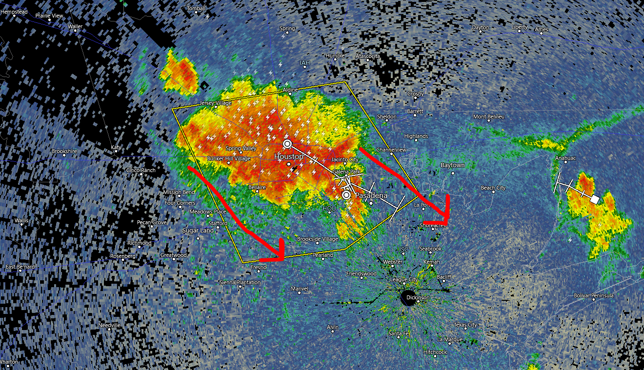
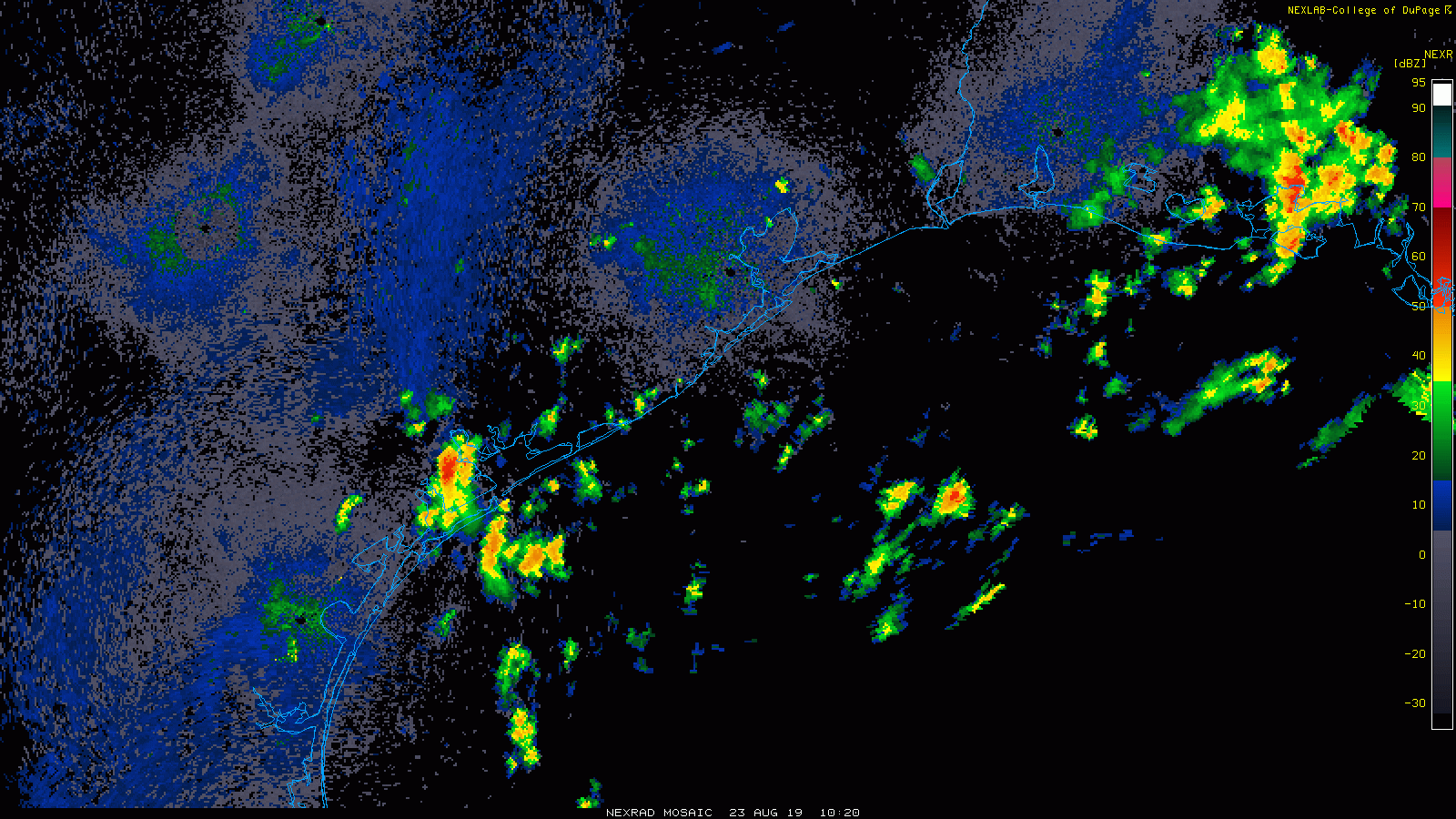
Quick local note: Strong to severe thunderstorms are racing through the Houston metro as of 5:30 PM. We expect these to drop south and east through 7 to 8 PM, bringing much of Houston a burst of heavy rain yielding perhaps 1 to 2 inches, as well as gusty winds. Areas south and east of Houston are likely to see some heavy rain from this as well. Areas north and west of Houston are mostly done with storms now or should be soon. The storms should begin to diminish and shift offshore after sunset.
Radar at 5:30 PM showed miserable conditions for commuters leaving the Inner Loop. Storms will press south and east this evening. (RadarScope)
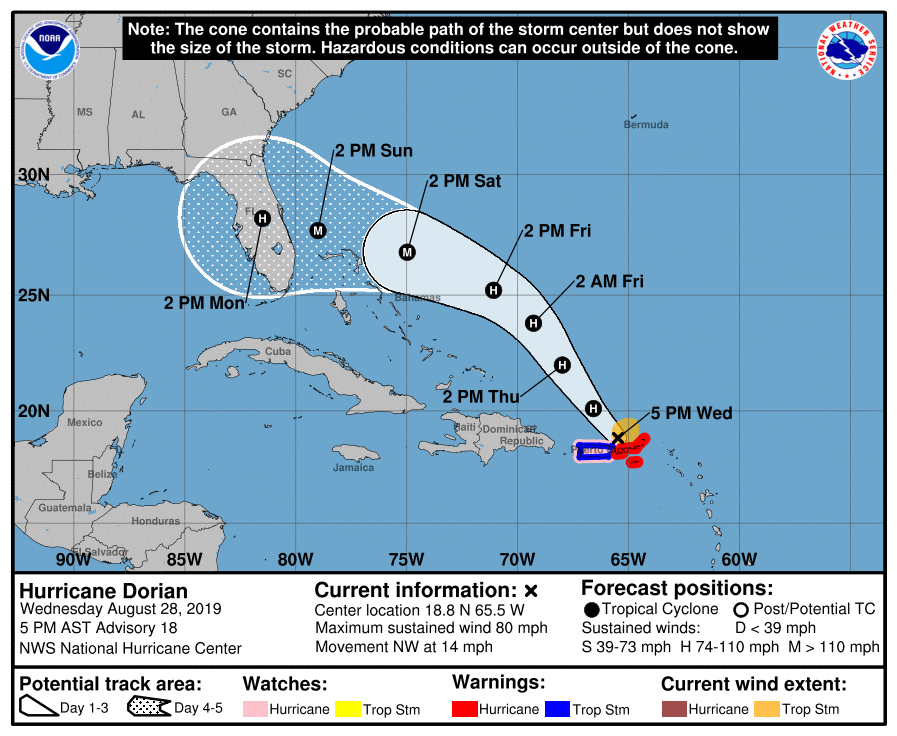
On to the tropics. Interest regarding Hurricane Dorian has spiked today as the track has shifted a bit and the upgrade to a hurricane occurred this afternoon. We’re here to walk you through what the future may have in store regarding Dorian.
One sentence summary
Hurricane Dorian is likely to impact the Florida Peninsula around Labor Day before heading into the eastern Gulf of Mexico where it could impact the eastern or central Gulf Coast next week, east of Texas, though there is still some degree of uncertainty.
Now
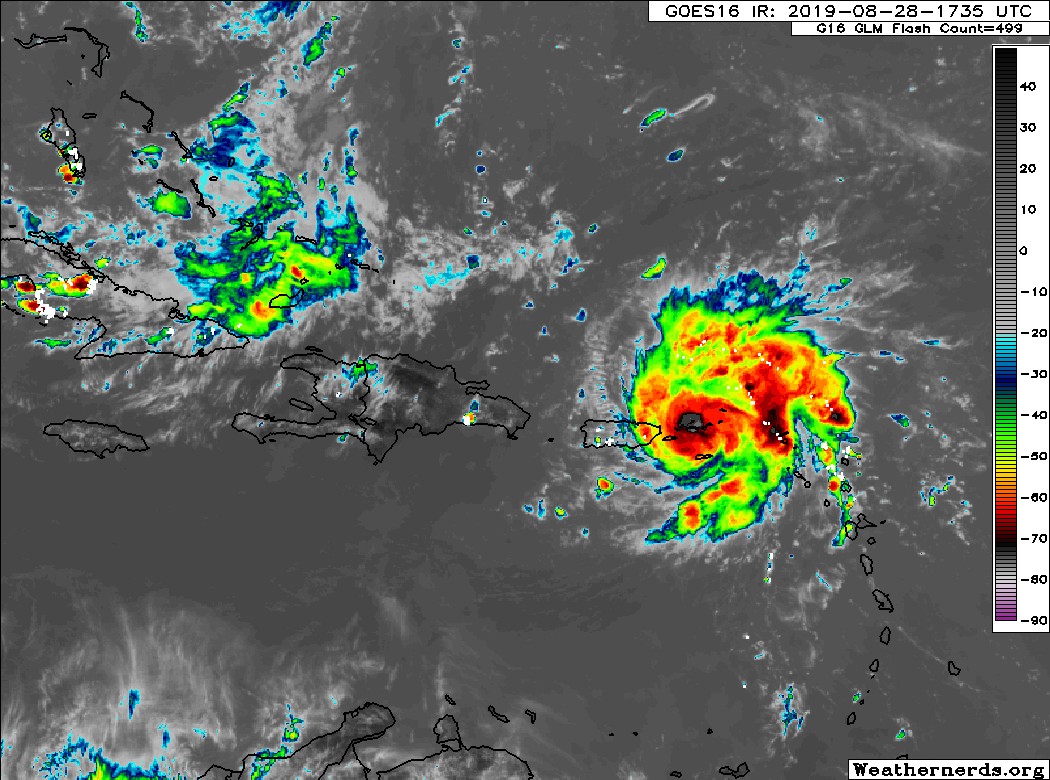
Dorian is located just northwest of St. Thomas in the U.S. Virgin Islands, as of the National Hurricane Center’s (NHC) 4 PM CDT advisory. Satellite shows a fairly healthy looking system that has managed to keep itself together in the face of adverse conditions around the storm.
Hurricane Dorian beginning to exit the Virgin Islands and Puerto Rico on Wednesday evening. (Weathernerds.org)
Dorian’s maximum sustained winds are 80 mph, and it’s currently moving to the northwest at 14 mph.
Through the holiday weekend
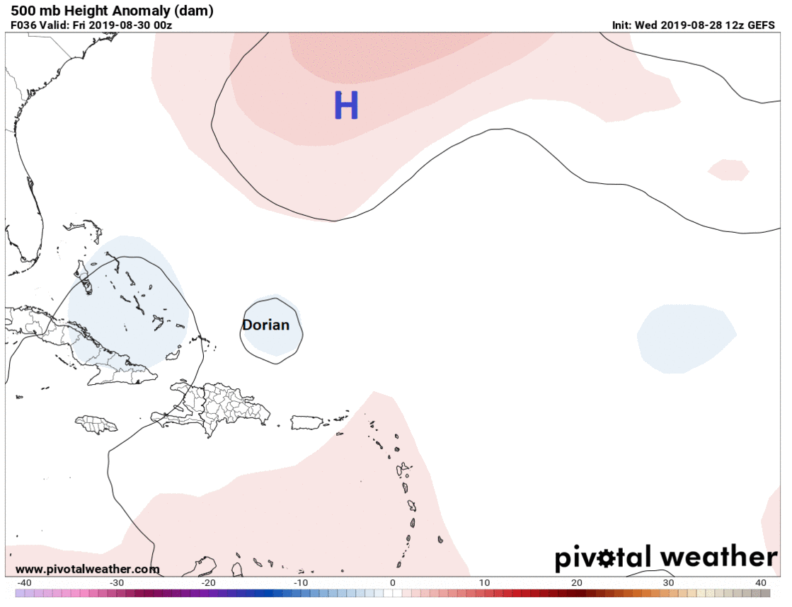
Dorian will take a cruise east of the Bahamas over the next couple days. As this occurs, high pressure over the Atlantic is going to begin building back to the west. This will force Dorian to begin to turn more to the west instead of northwest by the time we get to Friday night or Saturday.
High pressure building from near Bermuda west to the Southeast will force Dorian to turn west toward Florida over the weekend. (Pivotal Weather)
Around this time, forecast uncertainty begins to rapidly increase, unfortunately. The most likely scenario right now indicates that Dorian will remain on a westward heading toward the Florida Peninsula. Whether that’s aimed toward Miami, West Palm, Vero, Melbourne, or somewhere else is contingent on when Dorian turns and how sharp of a turn it is. Thus, you have to assume that at this point, the entirety of the Florida Peninsula needs to monitor Dorian’s progress, and they are all in the cone of uncertainty still.
The NHC forecast for Dorian shows a major hurricane approaching somewhere along the Florida Peninsula on Labor Day. (NOAA)
If you are planning a Labor Day weekend trip anywhere on the Florida Peninsula, you must be aware of this storm and that there is an increasing chance of some kind of impact beginning later Sunday or Labor Day Monday. We can’t tell you specifically what to do, but it’s a scenario you need to be aware of.
Beyond Labor Day
Uncertainty roofs beyond Monday regarding Dorian’s track. Much will depend on what’s happening over the Plains, how strong a trough of low pressure is across the Midwest and Mid-Atlantic, and ultimately how much the high pressure ridge over the Atlantic wants to build back to the west. This means numerous scenarios involving Dorian are in play.
An example of how much uncertainty there is beyond ~ day 3. Each "L" on this @Weathernerds map represents where the 51 Euro ensemble members places Dorian's center on Tues AM. This is a tremendous spread in possibilities, underscoring the need to not take any 1 solution literally pic.twitter.com/ERN1QZy3aP
The most likely scenario at this point, or at least the one favored by most weather models and ensemble members involves Dorian moving into the eastern Gulf of Mexico and then gradually turning to the northwest and north toward the central or eastern portions of the Gulf Coast. While we continue to believe this will not ultimately be a concern for Texas, we should continue to monitor Dorian’s progress through the weekend, especially given the high degree of uncertainty that exists right now. We will gradually gain some color on this tomorrow and Friday and can hopefully completely rule out certain possibilities for us here.
The bottom line on Dorian:
The odds of a major hurricane impacting Florida around Labor Day have increased significantly today.
There is still a high amount of uncertainty on track and exact timing of impacts, and folks from Louisiana through the Carolinas should be watching Dorian closely. In Texas, for now, we should just be checking in once a day to make sure we’re still in the clear.
If you have travel plans to the Florida Peninsula for the holiday weekend, it’s critical you remain tuned in and aware of this storm.
Besides major hurricane impacts in the region wherever the storm hits, extremely heavy rainfall will be possible over Florida and the eastern Gulf Coast or Southeast early to mid-next week.
That other Gulf system
Eric this morning noted the other feature we’re watching: A disturbance near Cuba. We expect that to arrive in the southern Gulf of Mexico this weekend. Weather modeling this afternoon continued to keep that pointed mostly well to our south and either into far south Texas or Mexico by midweek next week. Most also did not suggest it would strengthen a whole lot. Still, given the uncertainty surrounding Dorian and any potential interplay between Dorian and that disturbance (the systems won’t merge, but one could impact the other depending on location and intensity), we are going to continue to watch this one. The disturbance could also become a significant rainmaker for parts of South Texas or Mexico.
The good news is that after these two systems run their course, conditions look quiet in the Gulf again for a little while. More from Eric on Thursday morning.
Rainfall totals on Thursday were rather pedestrian across the region. Some folks saw maybe a half-inch or so. Others saw none at all. The bullseye was east of Mont Belvieu in Chambers County, which saw just shy of two inches. Santa Fe down in Galveston County also did fairly well.
Today could see slightly healthier rainfall totals setup in parts of the area, especially along the coast. Let’s jump in.
Today
Radar this morning shows just a few showers along the coast, with a good bit more offshore lifting northward.
Radar loop this morning shows scattered showers, some heavy, lifting north. Expect more of these to develop throughout the day. (College of DuPage)
Some of these showers have a bit of heft to them, so rainfall is going to be feast or famine today. We should see a general trend of more numerous showers and storms heading into this afternoon. Rain totals though will vary widely. Some folks will see no showers today, while others may get a healthy 1 to 3 inches in downpours. Those pockets of heavier rains are likeliest south and east of Highway 59 though. We should reach the low-90s today without much issue, except along the coast, which will be a touch cooler.
Saturday
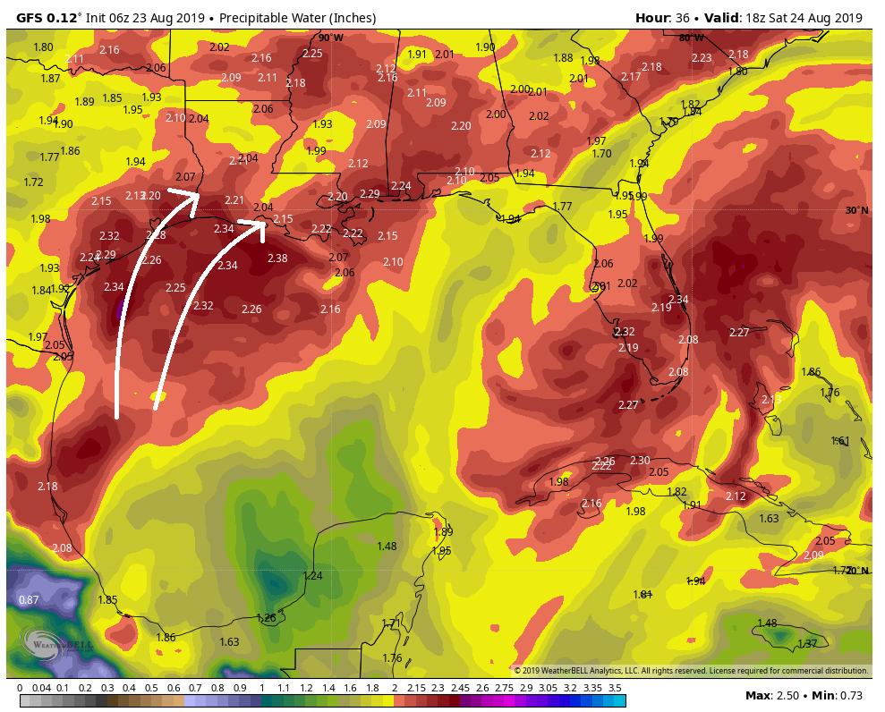
The plume of tropical moisture that’s helping to fuel these thunderstorms remains aimed at East Texas and Louisiana tomorrow, so I would again expect a fairly robust coverage of storms, particularly along the coast in the morning, gradually working inland in the afternoon.
The GFS model still shows a pretty robust area of atmospheric moisture (precipitable water) aimed at East Texas and Louisiana on Saturday. (Weather Bell)
Storm coverage may be a touch less than today, especially north and west of Houston. But again, expect feast and famine tomorrow, with some areas dry and other areas picking up an inch or two of rainfall. We should be able to get into the lower 90s before or in between storms tomorrow. Areas inland from Houston will be hotter. Storms should subside after sunset.
Thursday broke the streak. We fell one degree short of 100° officially, after 7 straight days of 101°+ in Houston. We don’t think we will hit 100° again for a bit, though I suppose one could sneak in here at some point over the next few days under the right setup. Regardless of all that, it continues to look hot and unpleasant for the foreseeable future, but at least we can mention a chance of rain almost every day.
Today
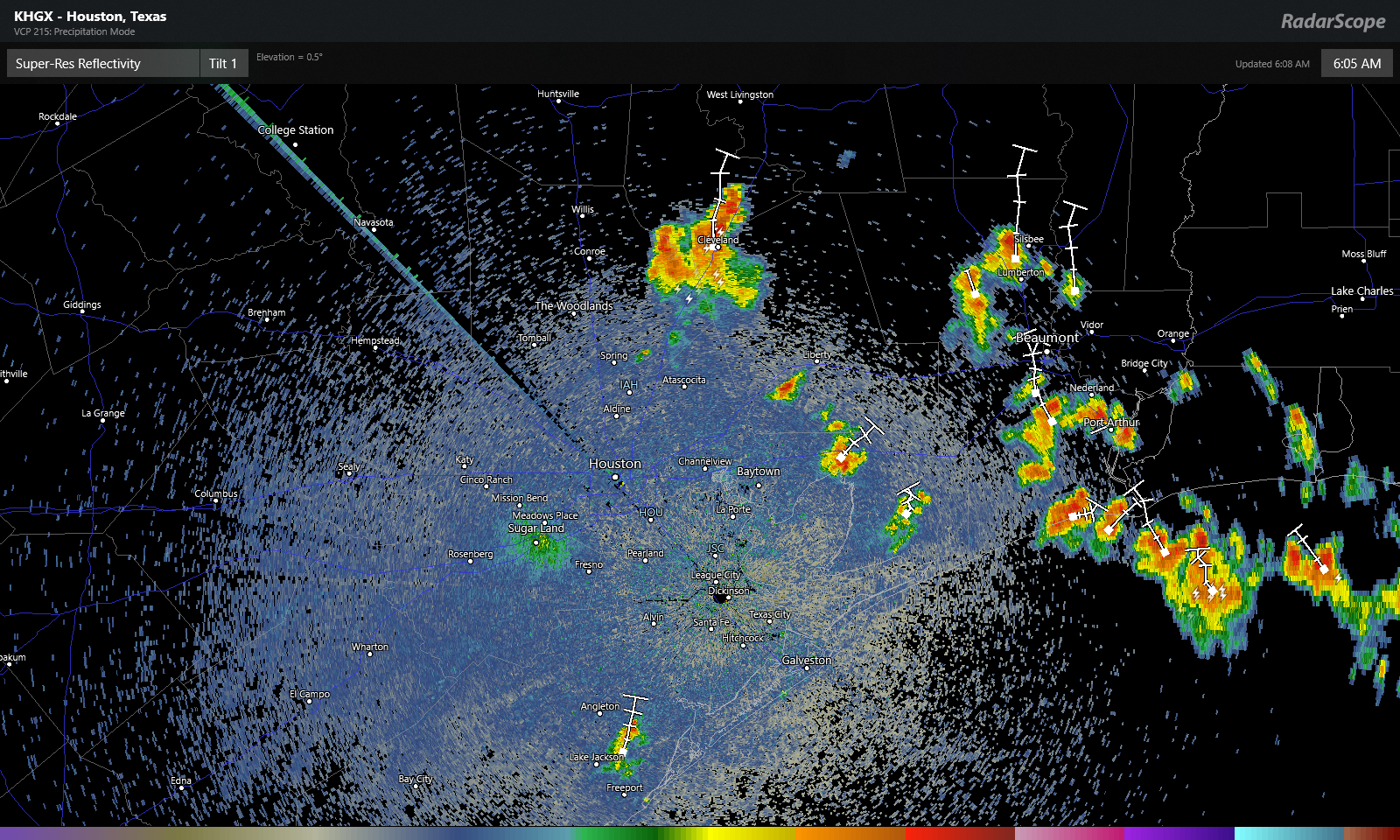
Radar this morning is already showing some showers and storms, mainly along the coast or east of I-45.
Radar as of 6 AM showed showers and storms mainly east of Houston, slowly drifting northward. (RadarScope)
The storms were slowly drifting to the north. These should gradually fade this morning, and we’ll expect sun and clouds with high temperatures aiming for the upper-90s once more. Air quality today will be fairly poor, so if you fall into “sensitive groups” on days with high ozone levels, you will want to take it easy and stay indoors when you can. A few additional showers are possible this afternoon with daytime heating, but like yesterday, consider yourself lucky if you see one.
Weekend
Both Saturday and Sunday look pretty standard for what we normally expect in the back half of August. Look for a mix of sun and clouds on both days. Saturday will see isolated to scattered showers or storms in the afternoon. Sunday will probably see slightly fewer showers. Rain chances will be highest as you go to the east of Houston. So Baytown likely has higher odds of seeing a shower than Katy this weekend.
High temperatures will likely top off in the mid- to upper-90s, while morning lows will remain steamy at around 80 degrees.