The weekend went about as advertised across southeast Texas with heat and humidity and a distinct lack of rain showers most of the time. We generally topped off in the mid-90s, with warm mornings. Much of this week is likely to play out in a similar fashion. It’s the end of the week when things get more difficult and possible forecast outcomes vary vastly as we will explain below.
Today & Tuesday
We expect both days to carry over the weekend weather: Expect sunshine and hot temperatures. An isolated shower can’t entirely be ruled out, but consider yourself lucky if you see one. We should do mid-90s today and middle to even upper-90s tomorrow.
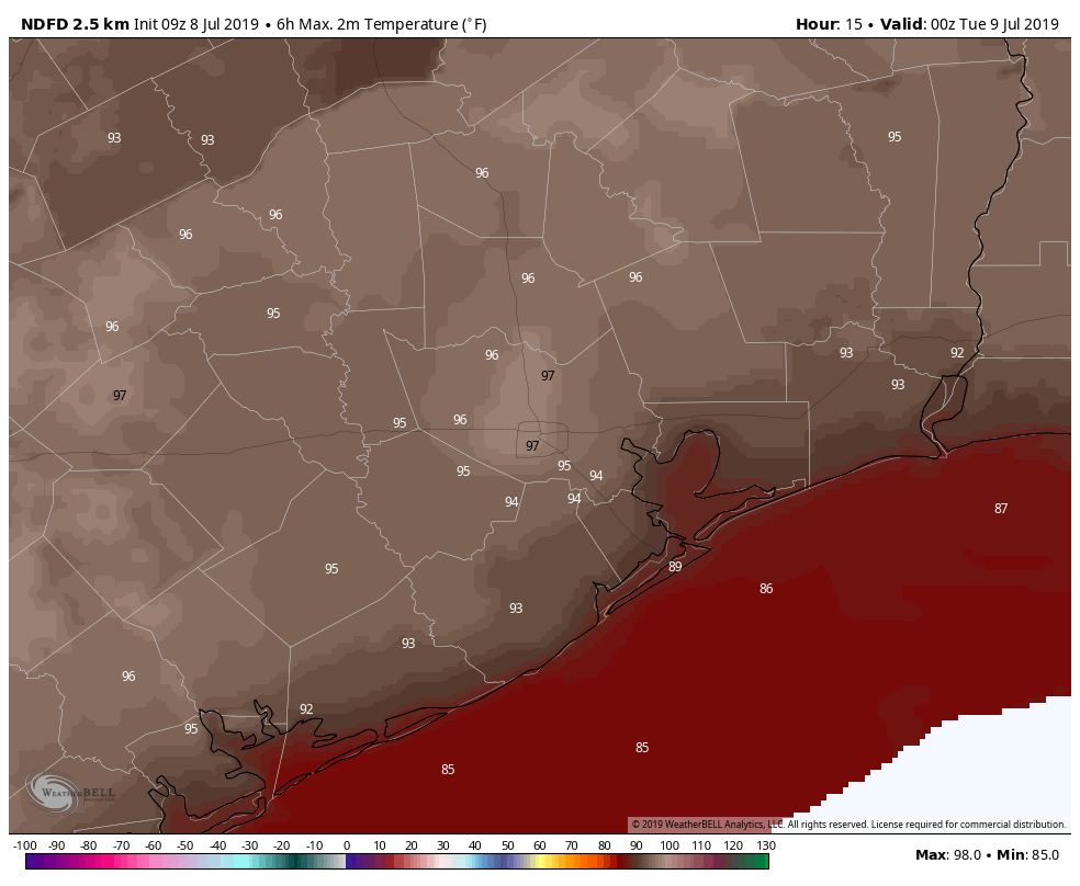
Take your usual heat precautions the next couple days, as heat index values should top off around 105°, and a few places may flirt with heat advisory criteria.
Wednesday & Thursday
Forecast confidence begins to slump backwards a bit for midweek. As of now, Wednesday looks similar to Tuesday, with mid- to upper-90s and high humidity, sunshine, and limited to nil rain chances. Thursday becomes more challenging. The disturbance to our east in the Gulf of Mexico will determine if we again reach for the upper-90s with dry weather or if we do low- to mid-90s and increasing scattered shower chances. We should hopefully have some clarity on this tomorrow.

Late week & weekend/Gulf system
Our forecast for the end of the week and weekend will depend primarily on what happens with the disturbance we expect in the Gulf of Mexico this week.
Here’s what we know right now.
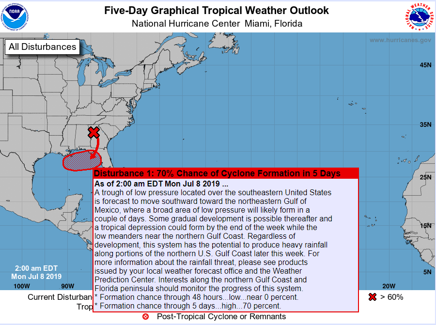
The one sentence summary: We expect a tropical system to develop in the northern Gulf of Mexico this week, likely to impact the Central Gulf Coast, with a slowly increasing possibility that it could also impact Southeast Texas.
I’m going to write in bullet points to keep thoughts distinct as possible here:
- As we discussed back on Friday, a disturbance will maneuver into Gulf of Mexico off the Southeast coast this week. This morning, it’s located over Georgia and will drop south to off the coast of the Florida Panhandle tomorrow evening.
- The National Hurricane Center is currently giving it 70% odds of development over the next five days, trending upward and likely to increase further today.
- Weather modeling continues to be in flux regarding the future of this system.
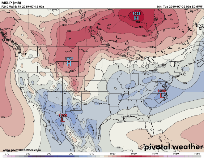
- The majority of modeling that had implied a possible quick turn north or northeast back on Friday has begun to drift more west with time, focused now on Central Louisiana rather than New Orleans and points east. The animation below shows the trend of the ECMWF operational model forecast for Thursday evening over its last several runs. Follow the “L” in the Gulf and the most recent model run shows you how far west this has trended since late last week.
- This trend in the modeling is rather stark from one run to another, but a meaningful minority of model data did imply this possibility all weekend.
- We need at least another day to iron out whether this drift west toward western Louisiana or Texas has legitimacy or will be a low possibility scenario.
- If this did impact our area, you would begin to notice it later Friday or early Saturday, exiting on Sunday. It’s impossible to say right now what specific impacts would be, but in a worst case scenario (still a low probability but higher than it looked 24 hours ago), we would have a strong tropical storm or possibly a hurricane in our neighborhood, along with all the issues (wind, tides, heavy rain) that come with those things. As of Monday morning, no reliable model says a hurricane will develop, but given how warm the Gulf is right now, I don’t want to promise that it could not happen.
- To note: This does *not* look like a Harvey scenario, with a multi-day stall. This is likely to keep moving at a steady clip.
- There is plenty of movement to this forecast still, so you absolutely want to stay tuned in early this week to developments. Meanwhile, given that the odds of a potential system have grown, make sure your hurricane kits are freshened up, just in case potential becomes reality.
On the total flip side of things, if this does end up a Louisiana issue, we would be on the hotter, offshore flow side of the storm and end up with a chance for upper-90s this weekend.
The bottom line in all this: Stay informed since this is an evolving forecast. Don’t focus on the most extreme map someone shares; there are a multitude of realistic outcomes at this point, many of which barely impact us at all. Don’t panic, but make sure you are prepared with a hurricane kit in case this does end up becoming our problem.You can find tips here.
That’s all for now. We may post an update this afternoon if something changes, but forecast uncertainty is likely to remain high through the day with some improvement tomorrow.
Fab as ever
Any respite from the heat would be welcome in the form of rain. I’m actually hoping it slides this way, just no flooding and strong winds.
Best weather source.
OK, any bets as to how soon before someone asks if they need to cancel their flight or if it will rain on them if they drive to Louisiana?
1.9″ of rain in ~45 minutes Sunday afternoon. Impressive drive-by thunderstorm.
Excuse me Matt, I’m planning on doing a session of Tree Yoga between 3:49 PM and 4:13 PM Friday afternoon in Seabrook. Could you please tell me how likely I am to hear thunder? I need to know if I should bring my Airpods.
My dog also likes to do Friday afternoon yoga and the thunder scares her.
Who knew weather could be this informative and entertaining at the same time. Thanks everyone! Have a great Monday👍
We were driving up 45, coming back from Galveston and hit that little squall. Super hard rain, over a very small area. I was a little jealous that it wasn’t sitting over our yard!
I’ve got a connecting flight in New Orleans on Friday around 7am. Hopefully this doesn’t impact that!
Matt/Eric…is it a bit rare that a low over the states gets attention from the NHC with the potential of moving into the Gulf, becoming a TS, then heading back inland?
Less rare than you think. It happens every few years I think. What’s unique about this one is that they had enough confidence to outlook it multiple days in advance and we saw some potential ~a week in advance. You don’t see that often with a disturbance coming from the land, and it speaks to how far weather forecasting has come in the last 10-20 years.
When is the earlier, or any, we may feel this disturbance in Houston?
Thanks