After yesterday’s rain and storms, we cleared out, and this morning we’ve cooled off a good bit.
Most locations are starting today in the refreshing 50s. (NOAA)
Today and tomorrow should feature Chamber of Commerce weather for all of Southeast Texas before we warm up and reintroduce rain chances next week. Let’s jump in.
Today and Saturday
Wall to wall sunshine should be expected for both days, with nothing worse than a few passing clouds. If you’re looking for something to complain about, you could probably be a bit perturbed by the wind today, which will gust at times around 25 miles per hour inland or even somewhat stronger at the coast. Wind Advisories are posted for Friday along the coast.
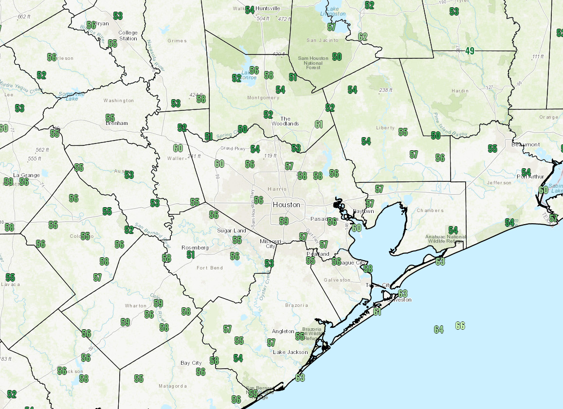
Otherwise, it should be relatively sublime. Expect temperatures to warm into the lower or middle 70s this afternoon. We’ll have another cool, pleasant night tonight, with temperatures dropping into the 50s in Houston and near the coast. Some of the northern and western suburbs and more rural locations will probably dip into the 40s tonight.
Look for lows in the 50s in the city and along the coast tonight, but 40s are likely north and west and in rural locations. (NWS forecast via Weather Bell)
On Saturday, we should warm up to about 80 degrees or so. Humidity should stay comfortable through Saturday afternoon.
Easter Sunday
We expect sunshine to continue for Easter Sunday. Look for morning lows to start in the low-60s. We will warm up to around 80 degrees once again. The difference between tomorrow and Sunday will be the humidity, which should be a bit higher and slowly increasing through the day on Sunday.
We’ve arrived at the doorstep of another weekend, which naturally means another chance of rain and storms. Let’s discuss how things should unfold.
Today
First, we’ll end the week on a mostly quiet note. Look for a good deal of clouds today. A few showers were seen on radar this morning down toward Matagorda Bay. Models aren’t especially bullish on rain chances today, but I wouldn’t be shocked to see some passing showers or even a thunderstorm, especially along and southeast of US-59 today. Temperatures will range from near the upper-70s to perhaps 80 or so with any sunshine this afternoon.
Tonight
Clouds will thicken up further as onshore flow ramps up. As moisture increases over the area, I expect a good deal of showers to develop and lift from south to north across the region. A thunderstorm is also possible. Most of us should just see a little rain tonight and Saturday morning. At this point nothing significant is expected. Low temperatures will be quite warm tonight and Saturday morning, barely dropping below 70°, if at all.
Saturday
Like last weekend, I am going to set you up with a user’s guide Q&A to this weekend’s storm.
When is it going to rain on Saturday? Overnight showers may try to diminish on Saturday morning. But any break should be relatively brief New showers and some thunderstorms will form in the later morning, especially on a line from Victoria to Sealy to Conroe to Lake Livingston. The best concentration of storms will be north of I-10 and probably along or north of Highway 105. This would basically be Conroe, Huntsville, Lake Livingston, Madisonville, etc. That’s also where the best chance for severe weather will be in our area. The really nasty stuff will be way off to our north, up toward Lufkin and Shreveport, LA. More on severe weather in a second.
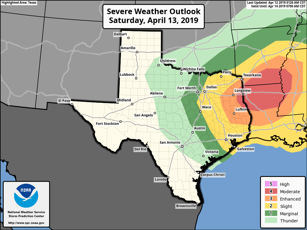
You’ve mentioned severe weather. What do I need to worry about this weekend? The Storm Prediction Center has adjusted their outlook again today.
Severe weather risk in Houston ranges from marginal to slight. Risks increase significantly to the northeast of our area. (NOAA)
Most of the Houston area is in a “slight” risk for severe weather. That increases dramatically to enhanced and then moderate as you head toward Lufkin and Shreveport. As mentioned above gusty winds and hail will be the main severe weather concerns this weekend around Houston. At this point, it would appear that Saturday’s storms will not be of the same coverage or intensity as last weekend’s severe storms were in the Houston area. Still, we’ll keep tabs on things to make sure that doesn’t change. As far as tornadoes go, they are unlikely in and around Houston.
So what about the Houston area?What should we expect? While the heaviest storms and rain will lift off to the north of Houston, I do expect at least a line of at least broken storms to develop Saturday afternoon.I would probably expect that line of thunderstorms Saturday afternoon, most likely between 2 and 6 PM from west to east across the Houston area. I don’t expect it will rain that entire time, but look for a short period of some heavy rain and thunder as that passes through. To reiterate, if storms become severe, the main threats will be strong winds and hail. The most likely portions of the area to see this will be to the north and east of Central Houston. Again, this shouldn’t be like last weekend, but we will keep watch.
We’ve got some active weather ahead this weekend, so let’s jump in and tell you everything we know right now.
Today
Right off the bat, if you have plans today, we do not foresee any serious issues. But (there’s always a “but”) that said, areas of fog have developed this morning across the entire area.
This map shows observed visibility (in miles) at various locations across the area, as of 5:30 AM Friday. It’s foggy, so give yourself a couple extra minutes out the door today if possible. (NWS)
The fog inland should gradually lift this morning, but it could persist along the coast well into this afternoon. Dense fog advisories are posted until 9 AM inland and until Noon at the coast. We’ll be partly to mostly cloudy and warm otherwise today. Highs should approach at least 80 degrees, if not the low-80s.
Tonight
For Houston, we don’t anticipate anything significant tonight, though a few showers or thunderstorms could develop after midnight, primarily north of I-10 and west of I-45, particularly out toward Sealy or Columbus up through Brenham or College Station. And even then, I really don’t think it would be anything other than very isolated through early Saturday morning. Look for low temperatures to only drop into the upper-60s.
In addition to an isolated shower or storm, fog should redevelop along the coast, possibly spreading inland again, though it shouldn’t be quite as widespread as today.
After mostly nice weather this week, we’re heading into the weekend warmer, but with a cold front on the way. That leads to unsettled weather. Let’s discuss.
Today
I don’t think we have any real issues today, but it wouldn’t be the biggest shocker in the world if a handful of us see a shower this morning as a weak disturbance pushes through. The best chances will be north of Houston, but ultimately, I do think most of the area will stay rather dry today. Onshore winds will continue to pump up temperatures, humidity, and provide a good deal of clouds. Expect us to reach about 80 degrees this afternoon.
Saturday
Tomorrow should behave a lot like today early on. Expect clouds, warm temps, humidity, and a chance of a shower through late morning. It gets trickier in the afternoon. The cold front is going to arrive in Houston sometime around mid- to late-afternoon. Because of that, expect a “dress for two seasons” day on Saturday.
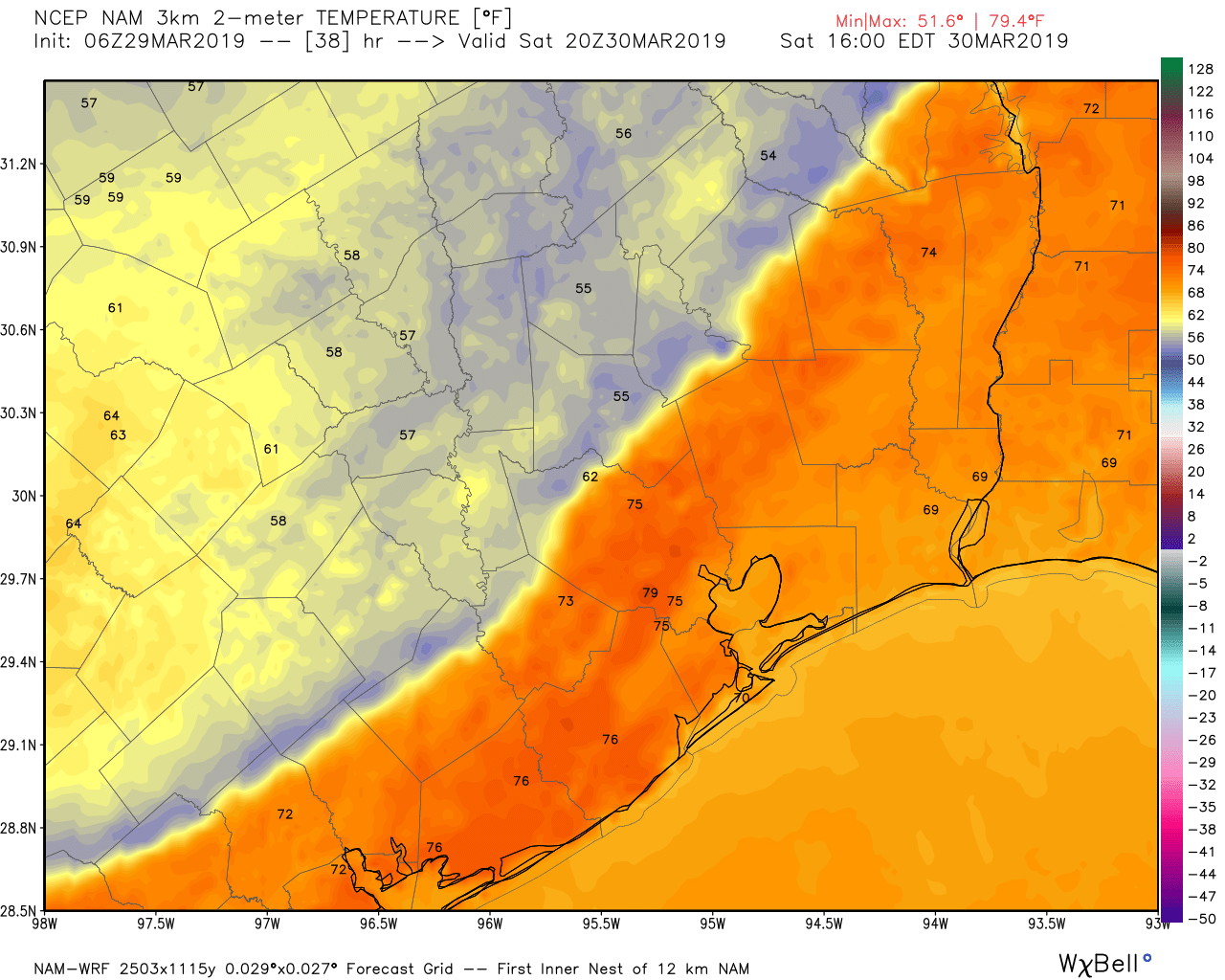
This is the NAM model depiction of temperatures at 3 PM on Saturday. This would have the southeastern half of the region near 80 degrees, while the northwestern half has dropped into the 60s and even some 50s. Dress for two seasons tomorrow. (Weather Bell)
The morning will be warm and humid, and at some point in the afternoon, it’s going to get chilly. We may reach 70-75° in the far northern reaches of the area, call it Huntsville or College Station. Once the front passes, temperatures will drop into the 60s and 50s. In Houston itself, we will probably hit 75-80 degrees, with temperatures falling into the 60s after 3-4 PM. South of Houston should get to about 80 degrees away from the immediate coast, and the front will arrive in the evening, allowing temperatures to join the rest of the region in the 60s or 50s.
For everyone, expect just a few showers as the front moves through, but the temperature drop will be the hallmark of this frontal passage.