After yesterday’s rain and storms, we cleared out, and this morning we’ve cooled off a good bit.
Today and tomorrow should feature Chamber of Commerce weather for all of Southeast Texas before we warm up and reintroduce rain chances next week. Let’s jump in.
Today and Saturday
Wall to wall sunshine should be expected for both days, with nothing worse than a few passing clouds. If you’re looking for something to complain about, you could probably be a bit perturbed by the wind today, which will gust at times around 25 miles per hour inland or even somewhat stronger at the coast. Wind Advisories are posted for Friday along the coast.
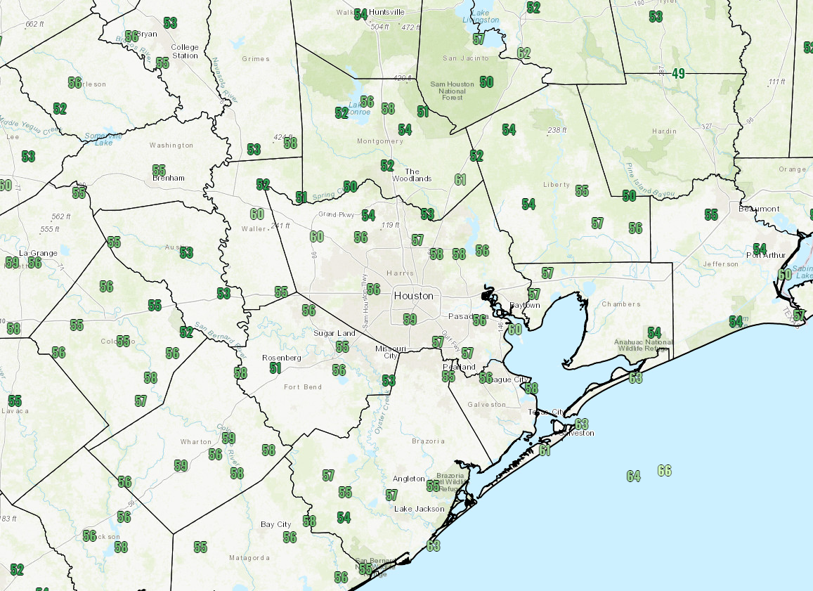
Otherwise, it should be relatively sublime. Expect temperatures to warm into the lower or middle 70s this afternoon. We’ll have another cool, pleasant night tonight, with temperatures dropping into the 50s in Houston and near the coast. Some of the northern and western suburbs and more rural locations will probably dip into the 40s tonight.
On Saturday, we should warm up to about 80 degrees or so. Humidity should stay comfortable through Saturday afternoon.
Easter Sunday
We expect sunshine to continue for Easter Sunday. Look for morning lows to start in the low-60s. We will warm up to around 80 degrees once again. The difference between tomorrow and Sunday will be the humidity, which should be a bit higher and slowly increasing through the day on Sunday.

Monday and Tuesday
As of right now, both days look alright in the Houston area. We should see a mix of clouds and some sun. Humidity will be on the rise, and we will start with morning lows in the mid- or upper-60s. Daytime highs will top off near 80 degrees. A shower can’t be entirely ruled out on either day, especially Tuesday, but the chances seem slim right now.
Wednesday through Friday
The forecast gets a lot more complicated beginning Wednesday. It appears a cool front is going to work its way through Southeast Texas. The questions right now are how far south and east it will get and how fast it will get there. Neither of those questions can be adequately answered today, as modeling has been all over the place on timing and intensity. Look for increased storm chances Wednesday and Thursday, and then perhaps a drop off in storm chances by Friday. Locally heavy rainfall will be possible with this system next week. We’ll get more into the weeds with this on Monday. Look for highs near 80 and lows in the 60s.
Next weekend
As Eric pointed out yesterday, we’ve been getting questions about weather for the BP MS 150 ride from Houston to Austin and the IRONMAN Texas event in The Woodlands next weekend. The hope is that the front will be off to our east by the weekend, allowing for limited rain chances and slightly cooler weather. I would expect upper-70s to low-80s for daytime temperatures, with morning lows in the low-60s right now. It’s still too early to speculate on wind conditions, but we should have a slightly better idea on this by Monday.
Eric – the link on my email takes me to April 1st. Confusing – it doesn’t seem like 39 out there this morning.
We did finally get 1/2″ of rain yesterday – of course it came after the city picked up my trash and lef tthe bin on the curb with the top open….
Thank you for a beautiful forecast! Some of these cool nights over the last few weeks have been a dream for us non-heat-and-humidity loving folks! May you have a lovely Easter weekend!
Thank you for sharing your ideas about weather for the BP MS 150. Much appreciated!