Good morning. Wednesday ended up being a mostly quiet day across the Houston area, with the exception of a funnel cloud-producing storm near Spring in the evening.
Wall cloud with funnel forming over Spring around 5:35 pm CDT! pic.twitter.com/N13kCB7Mv6
— David Gold (@dgoldwx2112) May 8, 2019
But for most of us, it was a welcome respite after Tuesday’s mayhem. Unfortunately that break will be short-lived. As we go through the next three days, each day will have high rain chances at various times (it will not rain the entire time), and that rain could be heavy and lead to flooding once more in parts of the region, including for some places that have yet to deal with any issues. It will be important to stay tuned into the forecast the next few days.
Eric and I will keep our Space City Weather flood scale rating at Stage 3 for this event.
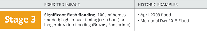
Just a word on this: Scales are tricky and linking historical flooding examples to a number is even trickier. Our purpose on this is to give you, as a reader, a simple sense of just how concerned we are about a flooding. Eric and I have had this on the cusp of release for months. But we have gone back and forth more than once on how to go about things. I have read some of the comments from readers, and a handful have had a tinge of confusion on some of the examples. It is absolutely critical that you, as a reader, understand that when we cite examples like Memorial Day 2015, that means different things to different folks. This scale is not meant to be interpreted as “this will be a repeat of Memorial Day 2015.” It’s meant to be interpreted as “Impacts in parts of the area could be similar to something like a Memorial Day 2015 flood or an April 2009 flood.” Like any scale, you should not interpret it as the be all and end all. We just want to give you a simple, easy-to-understand barometer of where we think things are. I’m going to work on a separate post for a quieter weather day to expand on this a bit more and talk more about some Houston rainfall meteorology & climatology. I just wanted to clear that aspect up a bit though today.
The highlights
- The Flash Flood Watch from NWS will go into effect at 1 PM today. It will continue until at least 7 PM on Saturday. It won’t flood everywhere, but it could flood anywhere.
- New rain through Saturday evening will average 5 to 8 inches, with some places seeing 9 to 12 inches. We can’t tell you exactly who those folks will be.
- It will not rain the entire time between now and Saturday night. The worst periods right now are likely to be tonight and then again at some point tomorrow night into Saturday.
- Dry weather resumes Sunday.
- Please stay in tune with the forecast and be sure you have a safe route to get from point a to point b before heading out on the roads the next few days, especially if it will be at night.
This morning
We’re starting quiet. The closest storms I see as of 5:30 are north of Beaumont and moving into Louisiana. So this morning, expect mostly benign weather with nothing more than just a few passing showers or downpours.
This afternoon
Weather modeling is now coming into good agreement that showers and storms will begin to develop across the region this afternoon. After about 2-3 PM or so, the risk begins to increase substantially. The evening commute will be one to watch, as storms could begin becoming more numerous across the region around that time.
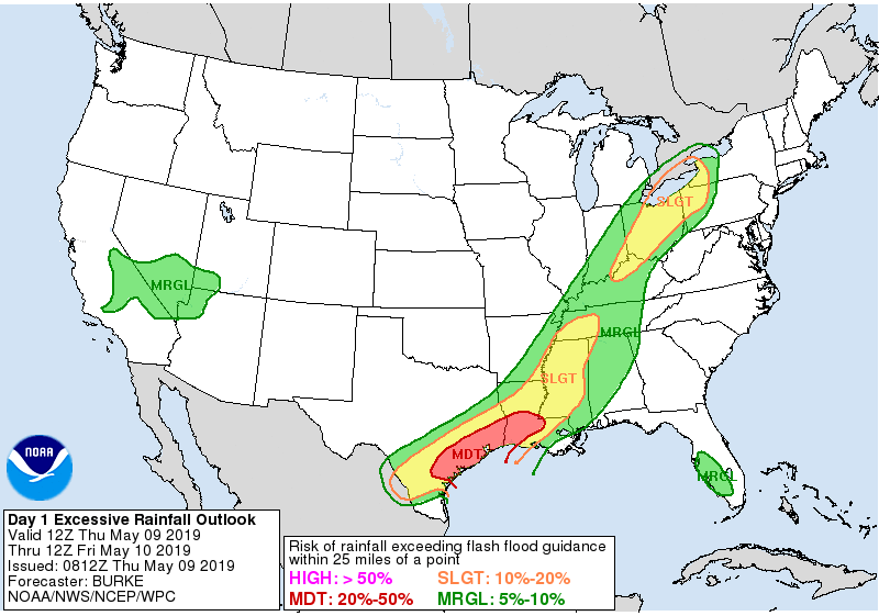
We will be under a moderate risk for excessive rainfall today from the National Weather Service’s Weather Prediction Center, meaning that there’s a good chance rainfall will lead to at least some flooding. Where, when, and how much is still TBD, but these storms late today will be capable of putting down at least 1 to 3 inches per hour. As we saw Tuesday, if they are slow enough, it can be more than that.
Also, any storms today could become strong to severe, and the majority of the region is in a “slight” risk for severe weather. Strong winds and hail are the primary concerns, with brief, isolated tornadoes not out of the question either.