Final Four-cast in a word: Swish

The humidity is just about outta here, after a summer-like Thursday. After tonight, we’re setting up for 3-4 straight chamber of commerce days for early April. If you have plans to take part in one of the many big events going on around the region this weekend, you’re in luck.

TODAY

The only blemish in the forecast will be today. Radar shows the bulk of the area is quiet right now. But showers and embedded storms are scattered about much of Texas this morning.

Widely scattered showers and a few storms from Hill Country to Houston this morning. (Intellicast)

Today should be one of those days where it could rain or briefly pour at virtually any time, though the bulk of the day may end up dry. Any storms today could drop some small hail, and you’ll likely notice an uptick in winds later this afternoon and evening. Severe weather is unlikely however.

Temperatures today will be tricky. We are already in the 50s to low 60s this morning in spots north of I-10 and mid 60s south of I-10. With clouds and showers and a slowly exiting cold front, I don’t expect to see a big jump this afternoon, so highs around 70 at best (upper 60s more likely) should be expected.

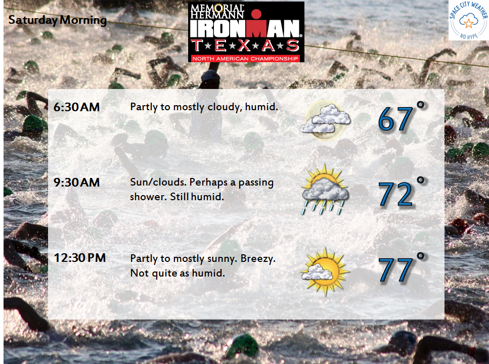
The rain should clear by later this afternoon or evening, and the humidity will press downward. Low temps tonight should bottom out in the low 50s, with a few upper 40s possible outside the Beltway. Gusty winds will make it feel a few degrees cooler, so a jacket will likely be in order tonight and Saturday morning.

Saturday AM forecast lows (Weather Bell)

See full post

Almost finished with the rain risks

Eric touched on the flooding issues for our friends to the east in the Sabine River basin yesterday. Check that post and visit the NWS Lake Charles website for the latest. Locally, here are the latest flood gauge levels and forecasts around Houston.

We got away with a mostly quiet Thursday. Judging by the weather model trends, today will hopefully have a similar outcome.

TODAY

The upper low over Mexico the last couple days is projected to end up over South Central Texas this afternoon. That means we are slowly drawing closer to the end of this frustrating weather pattern.

Upper level low moves over South Texas this afternoon and evening. (Weather Bell)


There will still be a few spokes of energy pivoting around the upper low today, so we will still carry a chance of showers or a thunderstorm throughout the day (showers this morning are popping up west of Houston already). But the heaviest storms will be in Eastern Louisiana and Mississippi. There will also likely be areas of showers/storms on the periphery of the upper low in interior Texas (basically north, west, and south of us). That puts us in between. So I’ll put an optimistic spin on things and say, “Yes, a chance of showers or storms through the day today, but I will lean toward the bulk of the day not being too bad.” We’ll see if that works out.

See full post

Yes, it is still going to rain

This storm has been maddening. You have to walk a very fine line between panicking people and providing actionable information. The balance is between the weather models (screaming 5-10″ of rain), the reality that big rain events aren’t that uncommon here, and the fact that people have a recent disaster (Memorial Day 2015) fresh in mind. It makes it difficult to communicate the information effectively. I know a lot of events and even some schools have been cancelled tonight and tomorrow. And it hasn’t rained much around Houston yet today, so people have to be very confused.

Here’s the scoop.

RECAP OF TODAY

The worst of this event was always supposed to be overnight tonight into tomorrow. Recall this morning, I said that most areas would see 0.5″ or less in all likelihood during the day today. Most have.

Rainfall through 4:30 PM Tuesday has been light for most. Blue specks near Beaumont indicate 1-2" though. (Radarscope)
Rainfall through 4:30 PM Tuesday has been light for most. Blue specks near Bay City, Beaumont & Orange indicate 1-2″ though. (Radarscope)

The good news today has been a very distinct lack of severe weather in Southeast Texas. We’ve managed to get through without any serious issues or warnings. The best parameters for severe weather will continue to exit to our east this evening and any tornado threat overnight will likely stay closer to the Golden Triangle than in Houston.

See full post

Setting the table for today and tonight’s storms

Good morning. It’s going to be a busy day across Southeast Texas, especially as we get deeper into it. I’ll update the Facebook page this afternoon if conditions warrant, and look for another post here this evening, once we get just a little more clarity on how things tonight into Wednesday will unfold.

THIS MORNING & AFTERNOON

There should be no serious issues this morning. A few showers will be around, but severe weather should be absent from our area. A few stronger storms could get going east of I-45 by Midday however.

Houston will be in an interesting spot today. The atmosphere is capped at present (meaning there’s basically a “lid” on things that will suppress storms this morning). As the day goes on, that cap will dissipate, and we’ll be able to start generating thunderstorms. What does all this mean in English? It may take some coaxing to get storms going today. That said, once they do get going, it won’t take a lot for them to become strong or severe, so you’ll want to stay on guard today.

Severe weather risk today is highest from Houston to points south and west. (NOAA)

So bottom line: Scattered showers and hit/miss thunderstorms today. Rain totals should be manageable outside of the heaviest activity. Most folks should see 0.5″ or less during the daytime today, with isolated higher totals in any more stubborn storms (where up to 2″ or so will be possible).

See full post