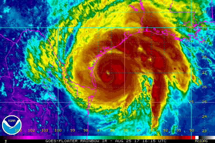
Houston area Flash Flood Watch: Friday PM through Sunday AM

The National Weather Service said this afternoon that a Flash Flood Watch will go into effect for much of Metro Houston (basically along and north/west of US-59/I-69) beginning Friday afternoon and continuing through Sunday morning. This includes the areas hardest hit by last week’s flooding.

Counties under the Flash Flood Watch Friday-Sunday (Iowa State/NWS)


As Eric pointed out this morning, there’s good reason for this. Most bayous in the city (Buffalo Bayou an exception) are back at their baseline levels. But, outside the city, streams, creeks, and bayous are running a few feet higher than normal still. And with a soggy ground any additional rain is unwelcome and can cause flooding concerns depending on how quickly it falls.

Basically, at this point all you need to do is continue to watch the forecast. There’s a bit less certainty with this event than there was last week. Also, it can’t be underscored enough that the rain totals implied by all models with this event aren’t anything like the last one. We want you to be prepared but not to panic here. We still don’t know exactly where the heaviest rain will fall, but we know there will be a few spots that see a pretty substantial amount of rain (not 15-20″ like last week, but 4-8″ in a few spots isn’t impossible).

So just stay tuned in through the weekend, especially if you have to travel around the area or live in an especially flood prone spot. We will have you covered.

See full post

Houston’s Tax Day flooding put into historical perspective

Note: This is the first in a series of reports by Matt Lanza that puts the Tax Day floods into perspective, and discusses what Houston should learn from this natural disaster.

On Monday afternoon the Harris County Flood Control District released its first official summary of the historic flooding that occurred last week in the greater region. I’ve read through it and compiled some highlights for here. (You can also view the report yourself in its entirety here). A serious thank you to Jeff Lindner at the flood control district who has worked tirelessly since last week to provide critical, useful, and interesting information to put this event into context and keep the region informed. He is also a must-follow on Twitter if you’re into weather, haven’t done so yet.

Report highlights

  • Rainfall rates of 1″ in just 5 minutes were observed in Harris County. The maximum hourly rate was 4.7″. The maximum amount in 12 hours was 16.7″
  • Harris County averaged 7.75″ of rainfall for the event. That’s equivalent to 240 billion gallons of water falling on the area. This exceeded Memorial Day (162 billion gallons) by almost 80 billion gallons of water. That event was more confined, whereas the Tax Day rains were much larger spatially.
Map of 12 hour rainfall totals and location/flooding description of significant waterways. (HCFCD)
Map of 12 hour rainfall totals. Click to enlarge. (HCFCD)

See full post

A rain-free Friday for Houston? Let’s try it

The rain is over. After days of being tortured by Mother Nature (and, you know, tigers), we can at least turn the faucet off for a bit, as drier weather builds into Southeast Texas for the weekend.

TODAY

As the upper level storm partially responsible for repeated rains finally begins to pick up some speed as it exits the Mid-Continent, that will allow for high pressure to settle in over our region for a couple days. That means we should have a good bit of sunshine today. Temperatures will pop into the low to mid 80s.

No complaints about today's rainfall forecast for Southeast Texas. (Weather Bell)
No complaints about today’s rainfall forecast for Southeast Texas. (Weather Bell)

See full post

Houston’s rain almost done for a couple days

Will Southeast Texas finally catch a few rain-free days? It looks that way, but we still have today to get through: One more round of rain and storms, but then we’ll see a couple days off.

TODAY & FLOOD UPDATE

The radar this morning looks somewhat similar to the way it did 24 hours ago at this time: A cluster of thunderstorms was dropping south toward Austin and College Station and in our general direction.

Radar loop shows storms dropping southeast across Texas this morning. (College of DuPage)
Radar loop shows rain and storms dropping southeast across Texas this morning. (College of DuPage)

As the morning goes on, these will move toward us. I suspect based on models and extrapolating this radar that they’ll arrive around mid to late morning again, perhaps a hair faster than yesterday.

The good news is that similar to yesterday, the rain should continue moving, so it won’t rain for too long over the area. That said, any rain at all will cause minor street flooding in spots and exacerbate some ongoing flooding north and west of Houston. But the bayous, etc. can handle this.

Any lingering showers will end this afternoon, and that should be it for organized rain for a couple days.

See full post