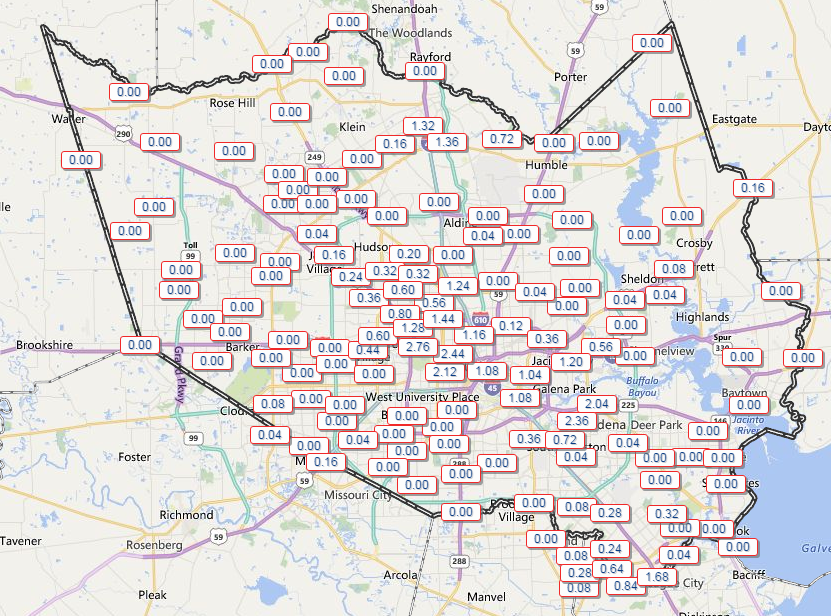
Yesterday was certainly fun, wasn’t it? A substantial chunk of our audience saw some pretty strong storms, but rain totals were very sparse. The axis from Pasadena through the Heights saw 1-3″ of rain, but many areas around city heard thunder and saw no rain. Such is the nature of summertime storms in Houston.
TODAY
We’re already starting off today with a somewhat active radar, as scattered showers reach the coast from about Sabine Pass down through Matagorda Bay. Showers will be around this morning. As we go through the day, I think the best chance of rain will shift south and west of Houston. The further north and east you go from the city, the less storms you’ll see by afternoon (though not quite zero). Temperatures should again try for the mid 90s.
WEDNESDAY-WEEKEND
Rain chances should step backwards tomorrow, and that trend will continue into the weekend. Yes, there could still be a few showers each afternoon on the sea breeze off the Gulf, but the majority of the area will stay dry. High temperatures each day will be 95-100 degrees in Houston. Low temperatures actually look somewhat tolerable (upper 70s, less 80s risk). Nighttime temperatures will be held in check by a slightly less humid air mass. The difference to you may feel imperceptible, but in reality, less moisture means the air can cool a bit further. Either way, true “cool” will only be found indoors through the weekend.
TROPICS
You may have noticed a lack of talk about the tropics since our super fast start back in June. The tropical Atlantic has been very, very quiet this season. Tropical waves are emerging off Africa, and in fact, the Atlantic has been somewhat hospitable to them in terms of wind shear, which has averaged below normal out there (above normal in the Caribbean).
Vertical wind shear has averaged above-normal in Caribbean and below-normal over tropical Atlantic over past 30 days pic.twitter.com/8DUQNCfxT7
— Philip Klotzbach (@philklotzbach) July 18, 2016
But it seems like each time a wave moves off Africa, it ends up getting eaten alive by Saharan dust. Wave after wave of dust coming off Africa has likely helped keep activity at a minimum out there.
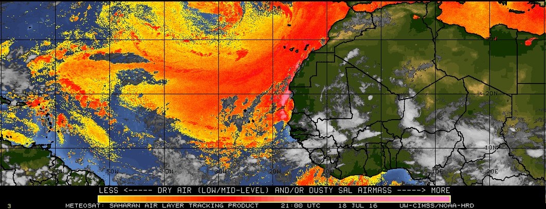
Dust from the Sahara is indicative of very dry air. Obviously, for thunderstorms to develop, dry air can be a big hindrance. Thus, with dust spread out over most of the Atlantic Basin for much of late June and July to date, it’s likely helped keep things at a minimum. Over the next 10 days or so, this is expected to continue.
Big bowling balls of African dust forecast to roll off the coast thru the end of July- love these @RyanMaue maps pic.twitter.com/SJKRve8xGL
— Eric Blake 🌀 (@EricBlake12) July 18, 2016
Dust isn’t the only factor that exists, but it’s a big one. Meanwhile, closer to home, an expansive ridge of high pressure seems to have put the kibosh on any activity being steered north in the Gulf. If you look at the mean upper level map over the Southeast since June 20th, you see two things: A ridge of high pressure centered over West Texas and New Mexico and a ridge of high pressure centered over Florida.
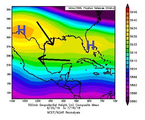
The two centers are likely large enough to be considered, basically, a large, sprawling area of high pressure. Simply: It would be difficult for any disturbances to cut north through that ridge. The upper air flow around the ridge steers systems and disturbances into far south Texas or Mexico. So the heat and dry weather we’ve had this summer has actually helped shield us from any tropical risks. Now, there are no guarantees that will continue, but so far so good.
All this said, it’s going to be wise to keep a very close eye on the tropics as we go into August and September. The Gulf is running 1-2°C warmer than normal pretty much everywhere. Almost the entire Gulf is well equipped to sustain and strengthen a hurricane.
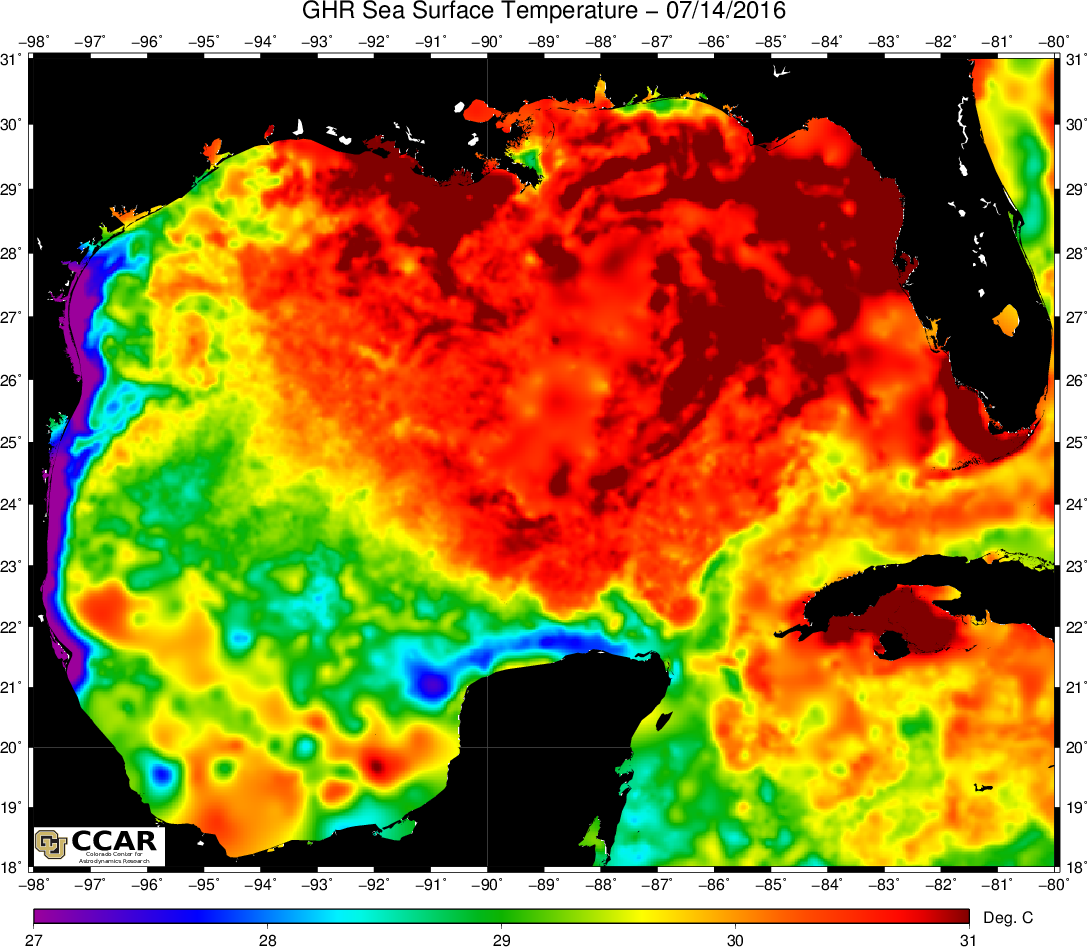
Just note that the waters off the South Texas coast are not “cold.” The scale chosen here was from 27°C to 31°C (81-88°F).
Dr. Jeff Masters and Bob Henson of Weather Underground wrote yesterday about the oceanic heat content available to storms in the Gulf and Caribbean. Since Houston is Space City and this is Space City Weather, the apt way of phrasing the available heat content is: “Rocket fuel,” especially in the Eastern Gulf and Caribbean. Obviously, if you have dust and high wind shear, the warm water will only do so much, but it still bears watching.
Bottom line: We’ve been fortunate so far, but if dust lessens and activity were to pick up as we go into August and September, the Gulf would be more than capable of feeding a hurricane the fuel it requires. There’s nothing out there right now that says this is going to happen, but as is always the case in Houston, it’s wise to be vigilant and prepared, just in case you need to act. Let this serve as your mid-season reminder. We will be sure to keep you covered if a system should develop this year. Fingers crossed.
I couldn’t help but notice that the waters from LA to Florida are the hottest in the Gulf, while the waters off Texas seem cooler. Is that significant?