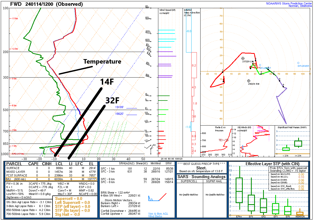
One of the challenges we face as forecasters during Arctic air events is that often times the models are too slow to push in the cold. This type of cold air is shallow and dense (go ahead and insert your jokes here). If you look at a vertical profile of temperatures from Dallas this morning, you can see just how shallow it is. The red line indicates temperature from the surface (bottom of the chart) to the top of the atmosphere. The temperature scale is tilted (skewed) on these atmospheric soundings (called Skew-T plots). But you can see that in Dallas, it was in the teens this morning at the surface. The line that corresponds to “850” on the left says that temperatures were about 34 or 35 degrees at that height, which is about 5,000 feet up. The line skews warmer about halfway there, so the coldest air is only about 2,500 to 3,000 feet deep.
A Skew-T diagram from Dallas this morning shows that surface temperatures were in the teens, while only about 5,000 feet above that, it was in the mid-30s. Cold air masses like these are extremely shallow. (NOAA)
Since the air mass is so shallow, it’s hard sometimes for modeling, particularly the global models we use 3 to 7 days in advance to pick up on how quickly that dense cold air is going to arrive. So based on our experience, we try to account for this by speeding up the arrival time of cold in our forecasts. Every now and then, however, you get a day like today. Temperatures dropped in Houston to about 37 degrees this morning. Meanwhile, as I write this at 3:45 PM, it’s 50 degrees outside. Weren’t we supposed to be cold today? Yes, we had the front stalling at the coast. Instead, it was as warm as 57 in Galveston, 53 at Hobby, 49 at Bush, but only 40 in Conroe and 29 in College Station.
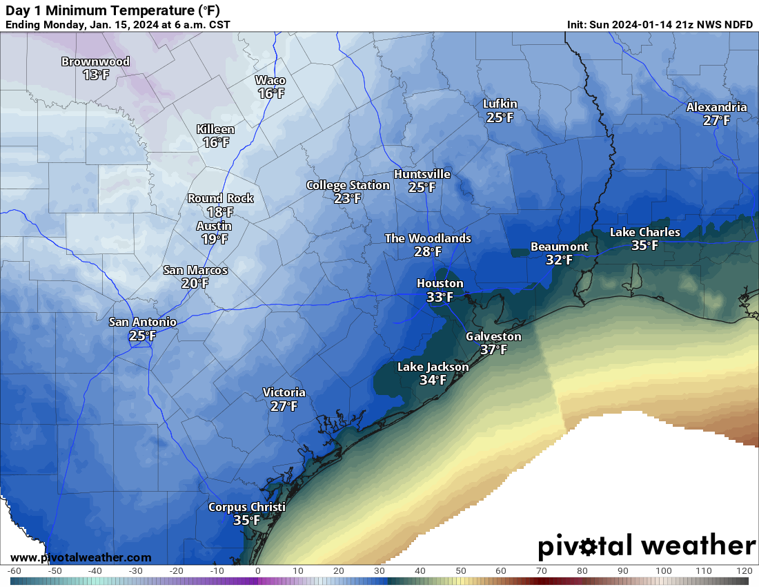
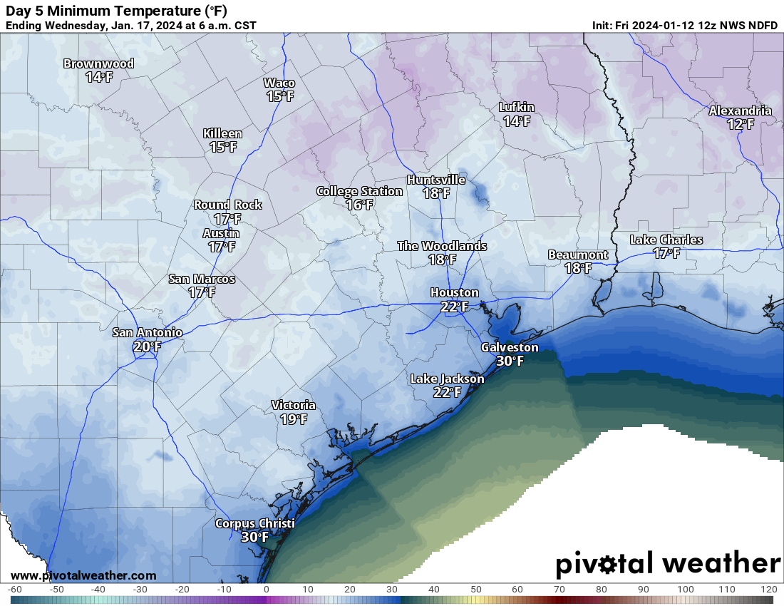
So, the obvious question most of you have is: Does this mean we aren’t getting as cold? No, it does not mean that at all. In fact, very little has changed, forecast-wise today. Once the sun sets, the cold air will resume its southward push, and by tomorrow morning, you can expect temperatures in the 30s in and around Houston and 20s north.
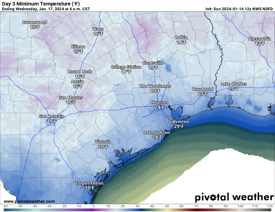
Forecast lows on Monday morning will be just above freezing in Houston and in the 20s north and west of here. (Pivotal Weather)
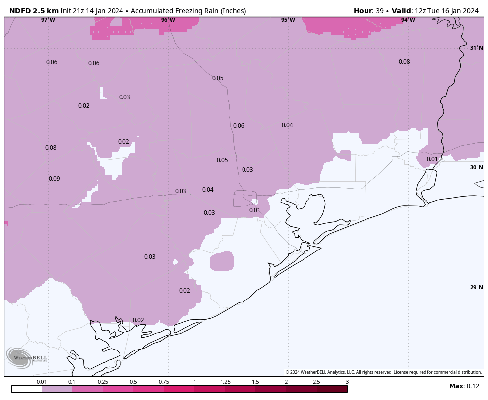
The problem tomorrow is that temperatures will go nowhere. We will stay in the low 30s with some light showers around, and yes that continues to suggest that light icing will be possible. That could begin as early as overnight north and west of Houston, continuing or expanding south and east during the day tomorrow. So, for the Monday holiday, watch for patchy ice north and west in the morning, across the entire area away from the coast during the afternoon and evening. This will not be a widespread major ice storm by any means, but bridges and overpasses will likely have patchy ice across the area tomorrow and tomorrow night, so please exercise extreme caution on the freeways.
Total NWS forecast ice accumulation will be very, very minor but that’s enough to produce patchy ice on bridges and overpasses in particular for Monday and Monday night, so please drive cautiously. (Weather Bell)
I do not want to speculate much at all on Tuesday morning’s commute and school issues right now. That’s above our pay grade, and I would just sort of plan at this point on Tuesday going normally for most folks but have a backup plan in case it does not.
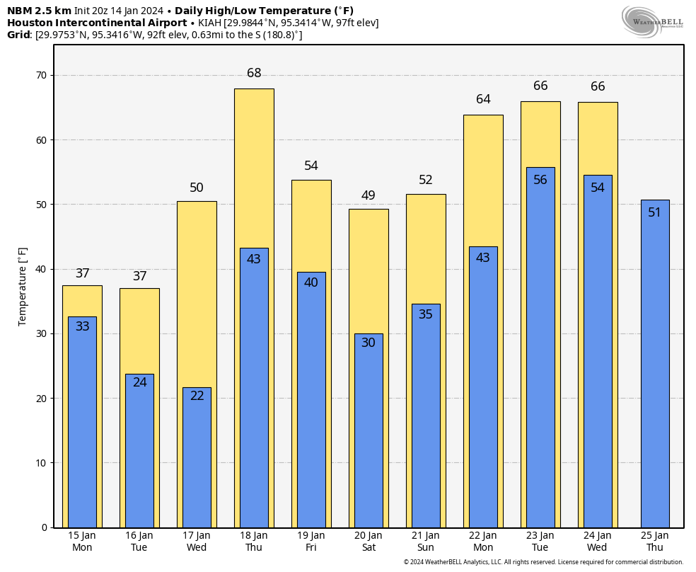
Forecast temperatures are virtually unchanged tonight, tomorrow, and Tuesday into Tuesday night across the area. So we aren’t looking any worse which is good, and this continues to look like a very cold but very manageable event. And if you want warmer thoughts, look no further than the National Blend of Models forecast over the next 10 days. Yes, another freeze is possible this coming weekend, but by all accounts it looks less significant than this first one. But several days in the 60s appear to be in our future. So take solace if you’re too cold.
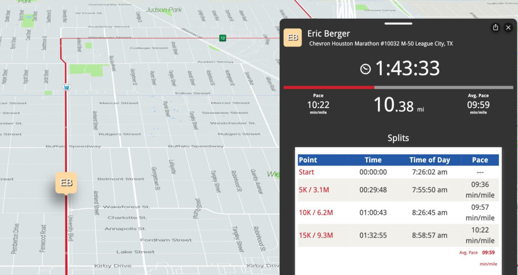
Good morning. I just want to open with a congratulations and good luck to all the marathon runners today. Especially our own Eric Berger!
Go get ’em, Eric!
We’ve been discussing the outlook for this event for a couple weeks now, so it’s nice that for the most part it’s not too bad for a run today. I hope it’s a good day for all!
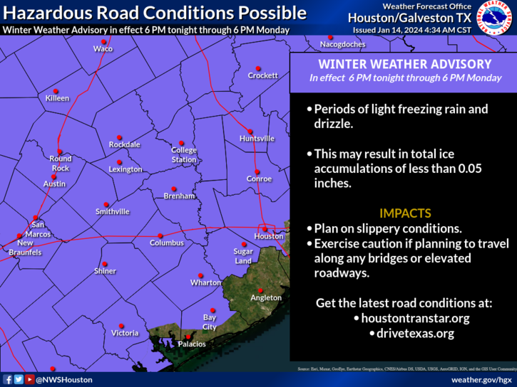
Winter weather advisory
Weather-wise, we have a couple notable changes to bring up today, mainly in terms of travel tonight and Monday. The chances of patchy ice have increased enough in the Houston area for the National Weather Service to post a Winter Weather Advisory down to Harris and Fort Bend Counties. Essentially, winter weather advisories now cover areas north of I-10 east of Houston and north of US-59/I-69 southwest of Houston.
Winter Weather Advisories include much of the area away from the coast and east to Lake Charles (not including Beaumont and Port Arthur at this time). (NOAA)
We are not expecting an ice storm in Houston, so let’s be clear about that. What we are expecting is that as temperatures drop back tonight and stay cold on Monday, light rain may produce patchy ice on area bridges, overpasses, and freeway flyover ramps. Given that accumulation is expected to be under 0.05 inches, widespread, major travel problems are not currently anticipated. But if anyone will be out and about tonight, Monday morning, and Monday evening in particular, please take it slow on the roads in case you run into some patchy ice. We don’t want to overstate anything here, but we really do hit on this because it’s not a typical concern we deal with here in southeast Texas. So just drive slowly and cautiously.
Tonight
Our first night of cold is tonight, and from a “winter so far” point of view, it does not look like anything special here in Houston. North and west of Houston is another story.
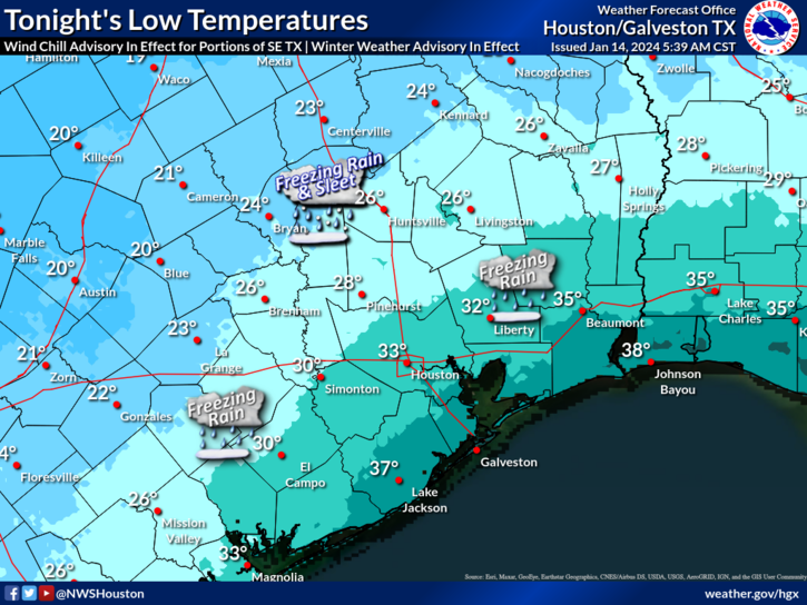
Temperatures tonight are expected to bottom out in the mid to upper 30s at the coast, low 30s in Houston, upper 20s to the north and west, and mid 20s in the Brazos Valley through Huntsville. (NWS Houston)
This will be the coldest air of the season so far tonight, with temperatures into the 20s north and west and low 30s in Harris County, slightly milder south and east toward the coast. With light precipitation falling, we’ll see some of that freezing rain or freezing drizzle producing light icing in our area, with some sleet mixed in well to the north and west.
Monday
Temperatures will move very little on Monday. Look for highs to be maybe a handful of degrees warmer than those low temperatures shown above. Precipitation will continue, periodically and lightly, through the day. Light icing risk will continue on bridges and overpasses, especially north and west of Houston.
Monday night
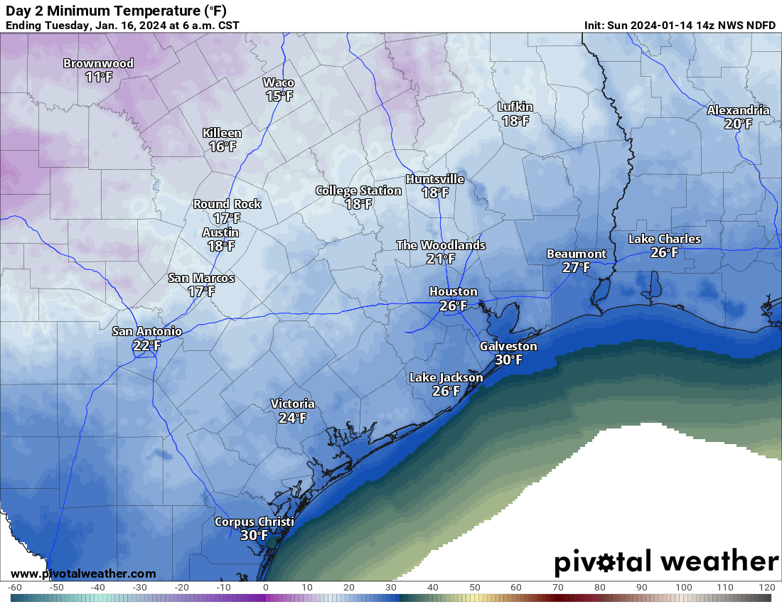
The coldest night of winter so far will settle in here tomorrow night. Look for lows in the mid-20s in Houston proper, low to mid-20s in the suburbs, and milder at the coast/colder north and west. Overall, this is a little bit less cold than initially expected but it’s still plenty cold.
Low temperatures Monday night into Tuesday morning will be in the mid-20s in Houston, near 30 in Galveston, and low 20s or upper-teens north and west of Houston. (Pivotal Weather)
In terms of duration, the city of Houston will probably see about 16 hours of temps near to below freezing Monday night into Tuesday morning. Look for a few hours less than that south and east and more than that north and west.
In addition, brutally cold wind chills will accompany this, with “feels like” temps in the low teens and single digits Monday night and Tuesday morning. Bundle up the kiddos Tuesday morning!
As of right now, icing is not expected to be a serious concern Tuesday morning, but with some lingering precipitation Monday night, I would not rule it out entirely. More on that later and tomorrow.
Tuesday
After the cold morning, the daytime won’t be a ton better. But we should manage low to mid-30s, briefly above freezing. You’ll see the sun on Tuesday too. So that’ll be nice. Wind chills will remain unpleasant all day, but the wind should begin to die off in the later afternoon.
Tuesday night
The coldest night of the event will be Tuesday night. Houston will bottom out in the low to mid-20s, with the suburbs in the low-20s. Areas north and west should dip into the teens. Cold, but manageable is how we described it yesterday, and that’s how I would describe it today as well.
Lows Tuesday night and Wednesday morning will be in the 20s almost everywhere, with teens to the north and west of Houston (Pivotal Weather)
Despite the stronger cold, the duration of temperatures below freezing may be a little less Tuesday night just because we’ll warm up faster Wednesday morning. So look for about 14 or 15 hours in Houston proper. Add to that north and west and subtract from that south and east. Either way, cold preparations need to be in place Monday night and Tuesday night for a hard freeze in the entire area away from the immediate coast.
Wednesday
Break out the shorts, as we’ll see highs well into the 40s and even warmer than that Thursday. More on that tomorrow or Tuesday.
We will have another brief update on things for you later this afternoon, focusing on any forecast changes to the icing risks.
One front is through the region, and now we wait for the big dog front later in the weekend. First, we do have some wind to get through today.
Today
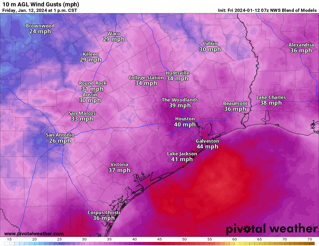
With the front to our east now, changes will be afoot today. We barely dropped below 70 (!) overnight, but we just crept into the 60s as I write this, and by the time you read it, it may be in the 50s. It will be a chilly one by mid to late morning. We’ll hold near or just above 50 for the majority of the afternoon. But it will be the wind that’s the real story today. Wind Advisories are posted, and we can expect wind gusts of 30 to 35 mph in Houston, and into the 40s over the bays and along the coast.
A reasonable estimate of what would be more like peak wind gusts today across the region, showing lots of 30-40 mph gusts and some stronger ones as well. (Pivotal Weather)
Winds will subside toward sunset, with a quieter night ahead. Look for lows tonight in the 30s in much of the area away from the coast. A light freeze will be possible north of the city and in some of the more sheltered areas south, west, or east as well. Temps should not be any colder than we’ve already seen this winter.
With our two posts per day now, we are aiming to update with each main cycle of model data that we are able to see. So there should be fewer big changes with each post. I’m going to change up this post a bit to sort of hit on the key points rather than give a chronological forecast. Here’s what we know.
Key messages
Front hits Sunday morning ushering in cold (most areas well above freezing)
Temps in the 30s to near 40 with an east or northeast 10 to 15 mph wind for the Houston Marathon.
Light precipitation likely Monday and light icing on area roads is possible, especially north and west of Houston. Tuesday AM commute may be impacted in spots.
Temperatures may stay at or below freezing much of the time Monday morning through Wednesday morning.
Hard freeze temperatures (less than 25 degrees) would likely last 8 to 10 hours at a time in Houston on Monday night and Tuesday night.
Wind chills will be as cold as 10 degrees or lower on Tuesday and in the teens much of Tuesday and Wednesday morning.
We warm well above freezing on Wednesday, with highs near 60 by Thursday.
When does it start?
We need to think of this in two ways: When does it get generically cold and when do we see freezing temperatures? The answer to “when does it get generically cold” is coming into focus. The front looks to hit probably Sunday right around sunrise now. Temperatures in the 40s will probably drop back into the 30s as the front hits, with a light freeze possible north of about The Woodlands on Sunday morning.
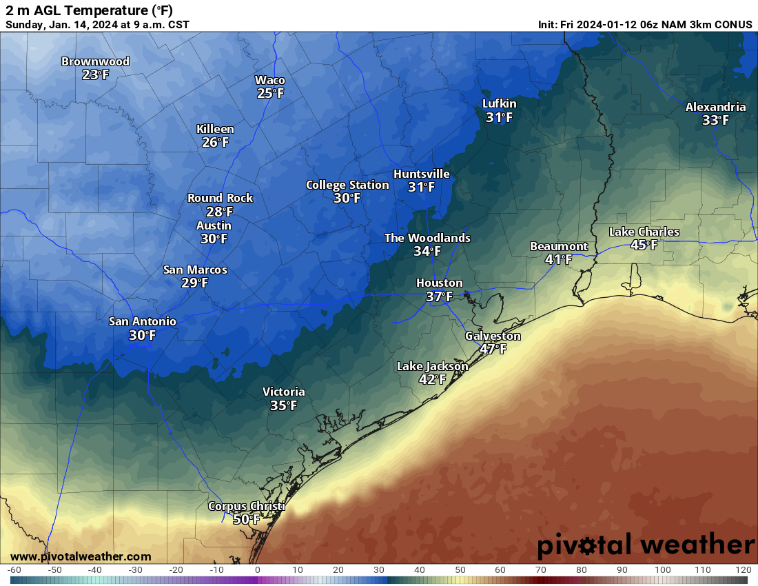
A reasonable model forecast of temperatures at about 9 AM on Sunday: Cold but most places comfortably above freezing, except perhaps the College Station area and up toward Huntsville and Madisonville. (Pivotal Weather)
The rest of Sunday would be cold but dry with temps in the 30s. A widespread light to moderate freeze is possible Sunday night into Monday morning. A more consequential freeze is possible Monday night into Tuesday morning, with temperatures in the 20s probably everywhere but at the coast, struggling to get above freezing on Tuesday afternoon. And then the coldest on Tuesday night into Wednesday morning. Thankfully, we should bounce back well into the 40s on Wednesday afternoon.
The current NWS forecast for Bush Airport. It will be slightly colder than this to the north of there and slightly warmer than this in the city of Houston and south toward the coast. (Weather Bell)
This obviously brings up a couple additional questions.
How bad is the Houston Marathon going to be?
The answer to that question depends on your preference I suppose. I would expect temperatures perhaps dropping as runners are in motion. We may start in the 40s and drop into the 30s or start in the 30s and hold steady throughout. The wind? It doesn’t look horrific, but it doesn’t look great either. We expect northeast to east winds of 10 to 15 mph or so. There will certainly be some gusts near 20 mph at times in there as well. The more meaningful wind should thankfully hold off until Monday or Tuesday.
How cold will it get and for how long?
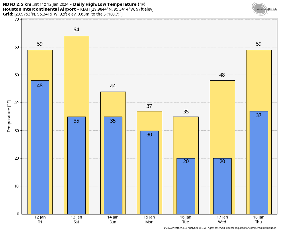
You can see the chart above for IAH. Let’s answer a few different questions. In Houston, the absolute worst case scenario right now would be temperatures dropping below freezing on Monday morning and staying there through Wednesday morning. Bear in mind that these would be temperatures more in the low-30s Monday (instead of the low to mid-20s like we saw during the February 2021 freeze). A more reasonable scenario is that we poke above freezing for a bit on Monday, then drop back Monday night and stay there into Wednesday morning. The coldest stretches (temperatures of 25 degrees or colder) will probably be limited to 8 to 10 hours at a time Tuesday and Wednesday mornings.
Wednesday morning should be the coldest morning of this event, and it’ll feel it for sure. (Pivotal Weather)
With gusty winds likely on Monday and especially Tuesday, look for wind chill values to drop into the teens much of the time, and at least for a time perhaps in the single digits. This is dangerous cold for pets and people outside, so please make sure to bring in the pets and check on anyone vulnerable to cold exposure.
Will there be wintry precipitation?
A disturbance passing over top of the cold air looks likely on Monday now. This will likely produce 12 to 24 hours of light precipitation across the area. With temperatures hovering near freezing, yes, that means we could see some freezing drizzle or light freezing rain as that precipitation moves through. There’s good news and bad news here. The good news is that amounts look light. So this isn’t going to be an all-out ice storm with lots of power outages due to ice buildup.
The bad news is that any amount of ice can make travel difficult. Monday is a holiday so there will be fewer people on the road already. That’s good news, but if for whatever reason you have to go out on Monday, please check on area roads before you leave. DriveTexas.org is a good resource to have. The Houston TranStar website will show you areas of ice. While there is still uncertainty on exactly how cold it will be Monday, it will be close enough to freezing to think that at least patchy ice will be possible on area roads, especially north and west of Houston and on freeway flyovers.
We don’t want to get into the prediction of traffic or school closures, but yes, you will want to pay attention to how things evolve this weekend for going to back to school or work on Tuesday, as Monday’s conditions could directly impact Tuesday’s commute too.
Will my flight be impacted?
We don’t predict airline behavior here, but yes, probably at some point Bush and Hobby will have some issues, but hopefully nothing major.
When does it end?
As you can see from the temperature forecast above, once we get above freezing on Wednesday morning, we are probably going to stay there into Thursday, with temperatures even near 60 degrees possible! Colder weather should come back next weekend, but it will likely be milder than we will see early next week. We will have more, including a broader look at Texas during this freeze event later today.
We hope everyone is having a good weekend so far. Congratulations to the Texans on a huge win last night, and we’re looking forward to next weekend’s return to the Playoffs! Today looks great, weather-wise, so whether you’re calmly watching football, taking part in the CFP Championship activities around the area, or anything else, it looks great. Tomorrow is another matter, and that’s why we’re writing a post on Sunday!
Tonight and Monday morning
Expect clouds and moisture to surge into the area tonight. By early Monday morning, we should have areas of light rain, drizzle, or spotty showers across the area. Nothing significant is expected before 10 or 11 AM, but the coverage of showers and periods of light to moderate rain should increase across the area.
Monday afternoon and evening
The good news is that the best parameters for severe weather tomorrow afternoon seem to be north and east of the area, as is often the case this time of year. The bad news is that we’re not in the clear, exactly. With clouds and showers around Monday morning, we’re likely to have a bit of a cap in place in the atmosphere, which tends to limit how severe storms can get. As showers continue Monday afternoon, they may build in intensity a bit. There are some signs that the cap may try to erode a bit, particularly east and perhaps northeast of Houston as we go into the afternoon, however, and that’s why I think we want to continue to watch tomorrow closely.
Most of the region is under a slight (level 2 of 5) risk for severe weather tomorrow. The main risks are strong winds and perhaps hail, with an isolated tornado not out of the realm of possibility (NOAA)
If a storm can get established in the area and intensify, it could produce strong winds or hail tomorrow afternoon. An isolated tornado, especially near the coast or to the east of Houston is not out of the question either. Eric will have the latest for you on this on Monday morning.
Meanwhile, a second shot of storms, coming in the form of a line of them from Central Texas will approach the area right around 5 to 7 PM, just in time for folks to head to NRG Stadium for the CFP Championship. While we don’t expect significant severe weather with this line of storms, it will be capable of producing lightning, gusty winds, or small hail as it moves through, so from a tailgating point of view, be ready to get inside.
You’ll also notice a big time change in temperature as that line moves through during the evening. We will see temperatures drop from near 70 degrees before the line of storms into the mid-50s shortly after the rain kicks up.
The temperature forecast around 6 PM as the line of showers and storms comes through shows 60s and 70s before it hits but mid-50s quickly after it moves in. (Pivotal Weather)
Beyond the severe weather risk, tomorrow looks breezy. Onshore winds of 20 to 30 mph with higher gusts to around 40 mph are possible. While this probably won’t cause major issues, there is the chances that some weaker tree branches could blow down. If you’ve still got holiday decorations up, you’ll want to secure those as well. Winds will ease up a bit in the evening hours, but by the time we get to Tuesday, we’ll see more wind, this time from the other direction (the north), gusting to 35 to 40 mph and stronger over and near the coast. There will be low water levels and rough seas on Tuesday.
Total rainfall will probably be an inch or less for most of the area. There may be isolated higher amounts in any downpours, especially east of I-45 and in the Beaumont-Port Arthur and Lake Charles areas. (Pivotal Weather)
Total rainfall will probably average a half-inch to inch for most places in our area. Some may see a bit less (especially down toward Wharton, El Campo, or Victoria), while others may see a bit more, especially east of Houston. No major flooding concerns are expected beyond the usual localized ponding in typical trouble spots.
Expect a roller coaster ride in terms of temperatures this week, and an increasing chance of the first real widespread freeze (a typical freeze, not a massive one) of the season on Saturday morning. Eric will have the latest on all that for you tomorrow.