As Eric promised yesterday, winter is not yet over folks. Stepping outside today, you’ll notice it feels a bit more like January perhaps. And while we do have warmer weather on the horizon, it’s pretty evident that winter is not quite ready to pack its bags just yet. At the bottom of today’s post, I’ve got a quick update on a some “polar vortexy” things that may be on your mind.
Today
“Blustery” is the word of the day. Winds are going to pick up this morning, and as temperatures stall a bit later this afternoon in the 50s, you’ll notice a little chill to the air.
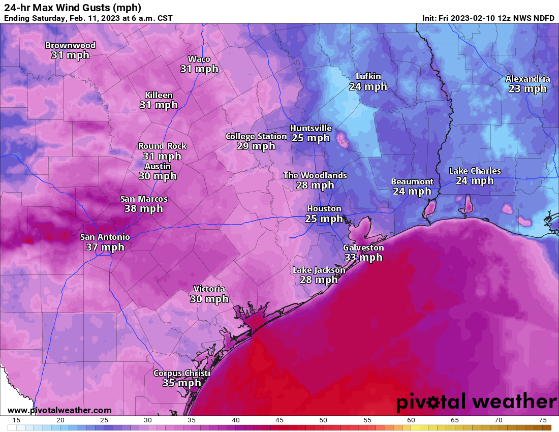
Northerly wind gusts may exceed 20 to 25 mph at times on land and over 30 mph along the coast (where a wind advisory is posted) and over the water.
Tonight
Winds will stay up some tonight, and temperatures behind today’s cold front will drop into the 40s and probably the 30s in many spots too. The wild card tonight will be how far west clouds are able to pivot. While they probably won’t have a gigantic impact on what you notice tonight, they will likely mean the difference between 40 to 45 degrees for a nighttime low or 35 to 40 degrees, where skies are clear.

Weekend
The weekend looks great for any plans you may have. Sunshine will dominate Saturday and Sunday with highs in the mid-50s Saturday and low-60s on Sunday. Morning lows will be in the 30s once more tomorrow night with a light freeze possible in spots north and west of Houston especially.
Next week
The weather is going to be a bit chaotic next week from a pure day to day perspective. In terms of impacts, we don’t see anything too major right now. We have two fronts that look poised to push through the area. The first would come Tuesday after a warm and humid Monday. After a brief cooldown Wednesday, we’d warm up late and into Thursday in time for the next front. Much like today’s front, this one has been flagging a bit of wind with it in various model guidance, so that’s one thing we’ll watch for Thursday afternoon. Behind that front, we’d turn rather chilly Friday and Saturday again. We will sort the details out for you further on Monday.
Stratospheric situation
We are beginning to get some questions about the potential breakdown of the polar vortex over the next couple weeks, with the thesis generally being that as the polar vortex weakens from the top (stratosphere) down (surface), it unloads colder air from the polar regions into mid-latitudes, where most of us live. Or as some misleadingly qualify it: “The polar vortex is coming.”
The catalyst for this would be a sudden warming of temperatures in the stratosphere (or SSW as many of us refer to it). The Washington Post’s Capital Weather Gang had a good piece on this yesterday with quotes from some experts I follow on social media. It may or may not be paywalled, but the general gist of things is this: There is a sudden warming of the stratosphere over the polar regions, thousands of feet above the surface. It fractures the otherwise stable polar vortex in the stratosphere. A process begins that gradually works its way from the stratosphere into the troposphere (where we live) that could begin a domino effect of perhaps reshuffling the weather pattern in the Northern Hemisphere in such a way that favors colder weather over warmer weather as we head into March.
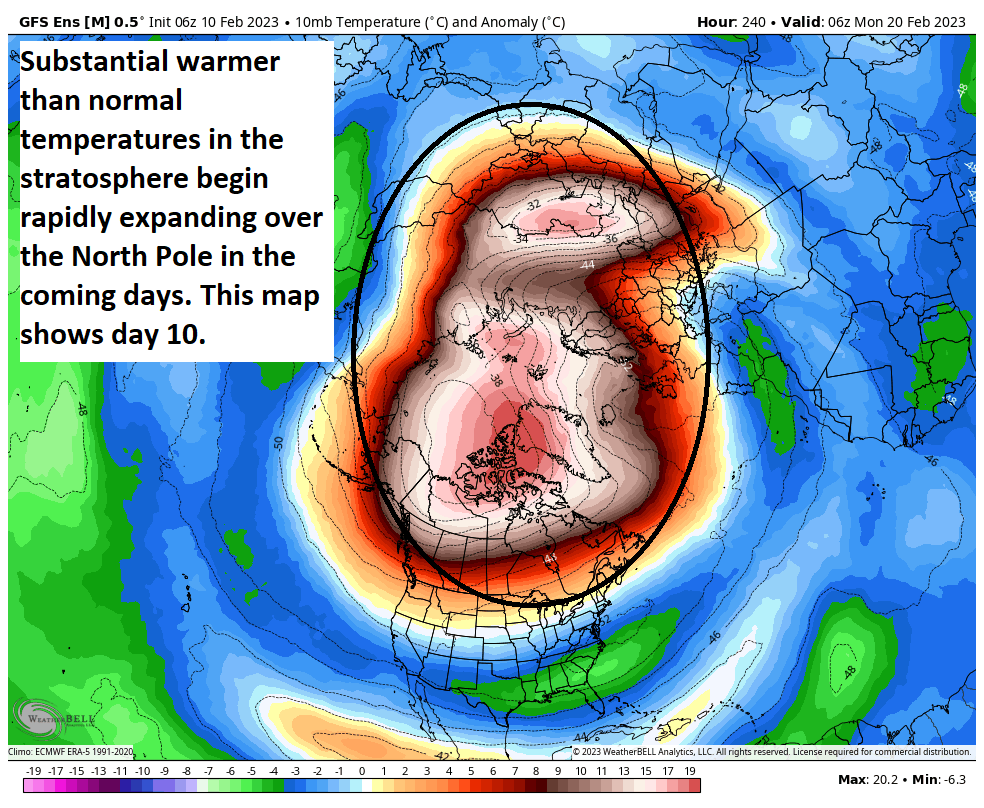
“Could” does not mean “will.” Nothing is guaranteed, as not all SSWs are created equal, and not all of them lead to a configuration supportive of cold in the Central & Eastern U.S. Researchers are still working to fully understand the factors involved in these types of events that happen every few years, so we still have a lot to learn before we can start discussing anything with confidence. In other words, neither Eric or myself or anyone knows if we’ll see some significant colder weather next month. That being said, as we head into next week and the week of the 20th, it will be interesting to see what the models start showing for the pattern over America. We’ll have a decent idea if this SSW has a meaningful impact on cold risks for the country later next week or early the following week I think. So stay tuned, but if you love cold, keep your expectations somewhat in check.


Was the 2018 “Freeze” a result of a SWW. Am a reader of the Wash Post — read the “Gang’s” article on the vortex yesterday and did not see the TX 2018 Freeze mentioned in context.
I assume you mean 2021? If so, it was not a result of a SSW, but that may have played a role in the overall pattern. I think too often it’s convenient to blame these things for specific events, when that’s not actually the case. These can act as catalysts for pattern changes of sorts. But they are not the cause of those changes.
Blustery: The blustery winds will cause the outside to feel chilly.
SSW: sudden stratospheric warming event.
If only they could bring the affects of solar flares and solar spots into the measure with the SSWs, then maybe I would be more inclined to pay attention.
Well, you could enlighten us all on these “effects”.
Here’s one piece of literature (1.09 sec Google search): https://angeo.copernicus.org/articles/37/375/2019/angeo-37-375-2019.pdf
I’m pretty sure, but not 100%, that this SSW event was being modeled well before the recent solar activity.
I’m fairly certain, though not 100% so, that this SSW was being modeled well before the recent solar activity.
I don’t know the impact factor of this journal, but here’s one piece of literature (1.09 sec Google search): “Notes on the correlation between sudden stratospheric warmings and solar activity, Ann. Geophys., 37, 375–380, 2019.
I’m not sure how solar impacts stratospheric warming, but I will say that all the physics are included within modeling.
Matt – I noticed a report on Drudge this morning that a humongous solar flare was observed by Nasa on Feb. 2 and has apparently generated a lot of comment in space weather circles. Do you think there may be a connection between that event and SSW discussed in your post – or are the two likely not related?
Unlikely to be related. Or if they are, not in the way that we’re discussing in today’s post. We’ve had plenty of SSWs occur without a concurrent solar flare.
We got some good news this week about La Nina.
https://www.cpc.ncep.noaa.gov/products/analysis_monitoring/enso_advisory/ensodisc.pdf
Yes, it would appear we are headed for an El Niño of some unknown intensity later this year.
Lanza. Still the best
Miss you man! Hope you’re well.
“The weekend looks great for any plans you may have. ”
I PLANNED to go for a swim in the ocean…