Good morning, and happy Friday. It’s a cool start to the day today, as we’re in the wake of a cold front that moved through last evening. We’ll have a round of gusty winds today before things settle down for the weekend.
Today & tonight
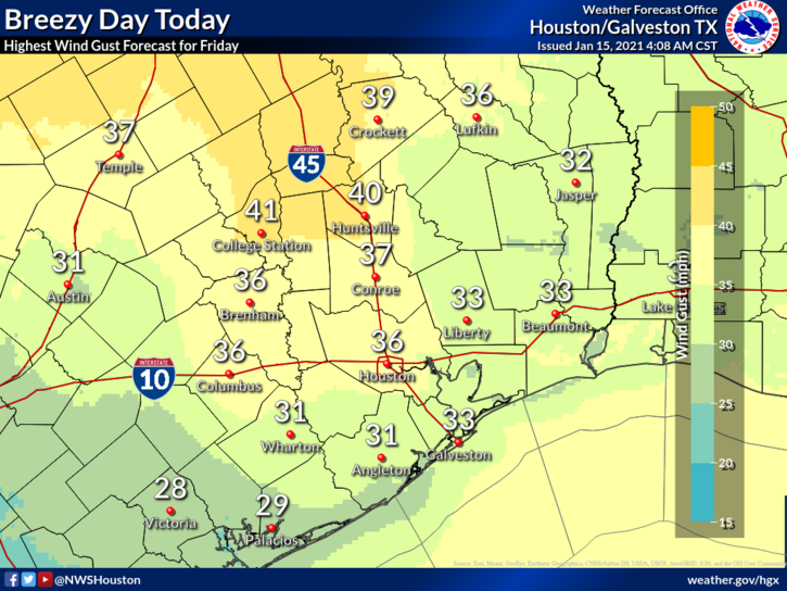
Today is starting off calm enough with clear skies, cool temperatures, and generally light winds. The clear skies and generally cool temperatures will stay with us today, with highs in the 50s. But the wind? That will begin to howl in just a few hours. We expect wind gusts of 25 to 35 mph area wide today, with some higher gusts possible in northern stretches of the region.
Wind gusts could exceed 30 to 35 mph in a few spots north of Houston later today. (NWS Houston)
A wind advisory is posted for late morning and early to mid-afternoon. With high winds and low humidity, it’s a higher than usual brush/grass fire danger day today. Relative humidity could drop below 20 percent at times, a very dry day.
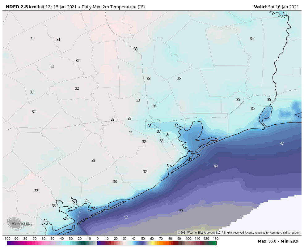
Winds will quickly settle down around and just after sunset, and they should be back to relatively calm conditions tonight, with lows near freezing north and west of Houston.
Lighter winds and clear skies may allow temperatures to drop to near freezing north and west of Houston tonight, with mostly 30s elsewhere. (NOAA forecast via Weather Bell)
Look for 30s elsewhere, with near 40 at the coast, a chilly night.
Saturday through Monday
After today, fair, quiet weather will be the story through Monday. Look for sunny conditions with just a few clouds on Sunday and Monday. Temperatures will slowly warm through the period, topping off in the upper-50s on Saturday, low-60s on Sunday, and mid-60s on Monday. Morning lows will stay cool, with 30s to near 40° on Sunday morning and mostly 40s on Monday morning. Winds will stay light but could pick up a bit on Monday afternoon as onshore flow redevelops.
Tuesday and beyond
A pretty messy weather pattern is expected Tuesday through Thursday or even Friday before a cold front finally clears everything out. Onshore flow will transport really humid air back into the region Tuesday and Wednesday, likely leading to scattered showers. The problem in this period is that details around the forecast continue to fluctuate both in terms of how much rain we see and where it falls. We know that the potential will exist for heavy rain and at least some thunderstorms. But we don’t know if it’s more a story for our area, farther north toward Shreveport, LA, or for all of eastern Texas and western Louisiana. We will have a full update on this for you Sunday or (more likely) Monday.
Good luck to him, as he runs the virtual Houston Marathon! Best of luck to all our readers that will be participating as well (and congratulations to those that have already wrapped it up). We’ve got some very nice weather yet to come.
Today and tonight
We should see ample sunshine through the day today, with just a little patchy fog in spots dissipating this morning. The cold front mentioned above will push through the area probably around late afternoon or early evening. I don’t think you’re going to notice much more than a wind shift and some clouds as it passes. Winds may get a little gusty in the wake of the front. Look for highs today in the 60s, possibly well into the 60s in spots.
Tonight sees clear skies and breezy conditions with a northerly wind gusting up to 20-25 mph at the coast.
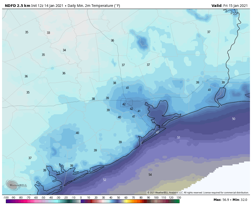
Tomorrow morning will be another chilly one with 30s and 40s area-wide. (NOAA via Weather Bell)
Temperatures will again be chilly, with lows near 40 degrees or in the 30s north and west of Houston to mid-40s in the city and near the coast.
Friday through Sunday
Basically, the entire weekend looks sunny right now. There could be some lingering gusty winds on Friday, especially near the coast and Galveston Bay and a few high clouds on Sunday, but other than that, it will be blue and beautiful. Highs will range from the upper-50s to low-60s with lows in the 30s and 40s. About as nice as you could ask for in winter in Houston.
Monday and Tuesday
We would expect Monday to be an extension of the weekend with a good deal of sunshine. Temperature should increase somewhat, however, with highs in the mid-60s after morning lows in the 40s. Tuesday will see clouds begin to increase as we begin to get stronger onshore flow and warmer temperatures. Look for fog, clouds, haze, or showers and highs perhaps pushing 70 degrees after a morning in the 50s.
Midweek next week
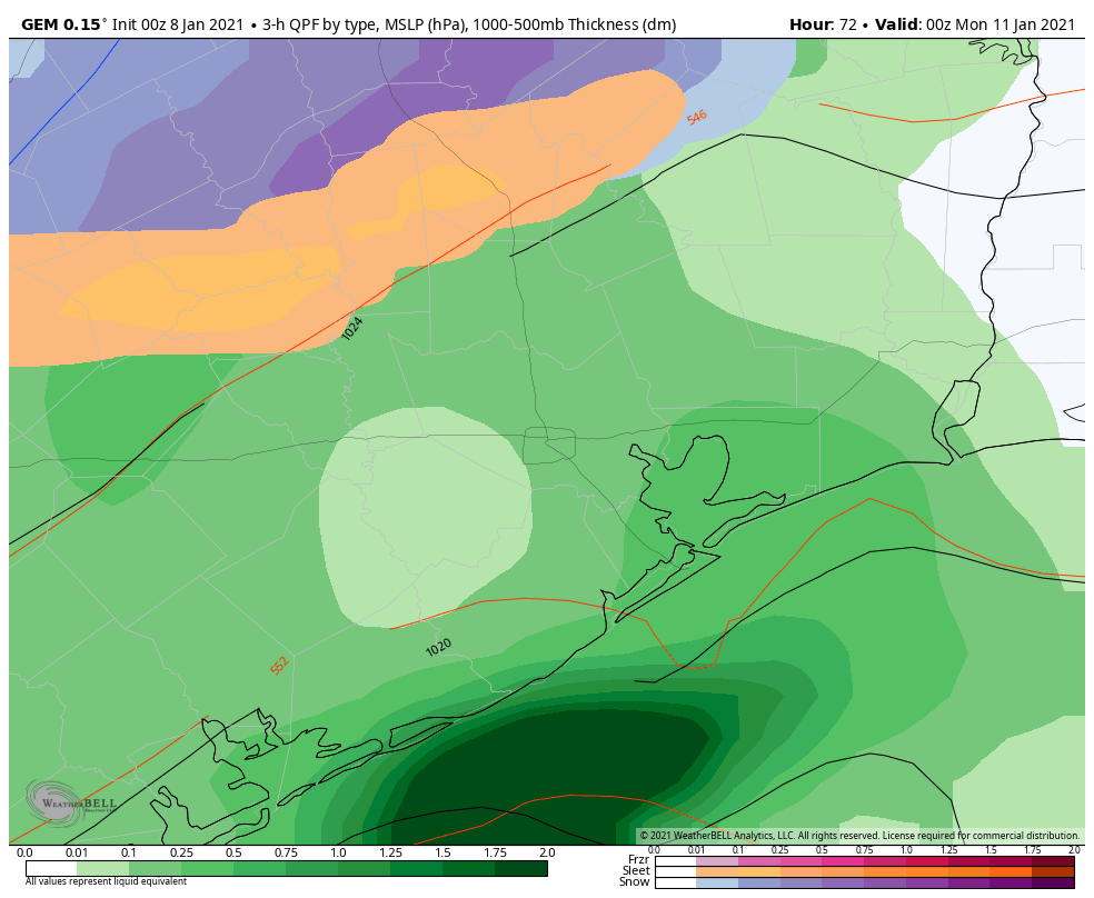
Tuesday’s onshore flow and increasing clouds heralds our next cold front. Look for that to cross around Thursday, give or take a day. Ahead of the front: Scattered showers and thunderstorms, some perhaps heavy.
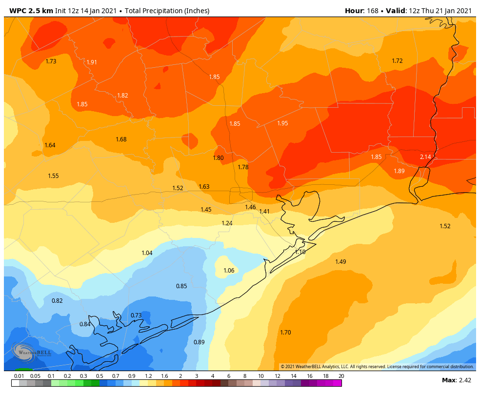
Rainfall expected through Thursday morning next week is 1 to 2 inches area-wide, with perhaps a little more after the period. (NOAA via Weather Bell)
The early indications point to about an inch or two of total rain from the showers and storms that will come ahead of and with Thursday’s front. But there’s a good deal of uncertainty on specifics in this timeframe, so watch for some changes as we get closer.
Good Saturday afternoon. With a bonafide winter storm on the way, we’ll keep you posted on things this weekend. Most of the morning model data is in, and we can discuss some of what is shown and lay out some thoughts for what might actually happen tomorrow.
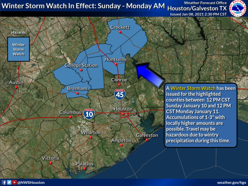
First, the housekeeping: A Winter Storm Watch (as of 2 PM CT Saturday, still a watch) is posted to the north and northwest of Houston for the Brazos Valley, Walker, Trinity, and Houston Counties. We expect this to be upgraded to a warning before this evening, and it’s possible an advisory or watch is expanded south also.
Winter Storm Watches are in effect for Sunday northwest of Houston. These will be upgraded to warnings later today. (NOAA)
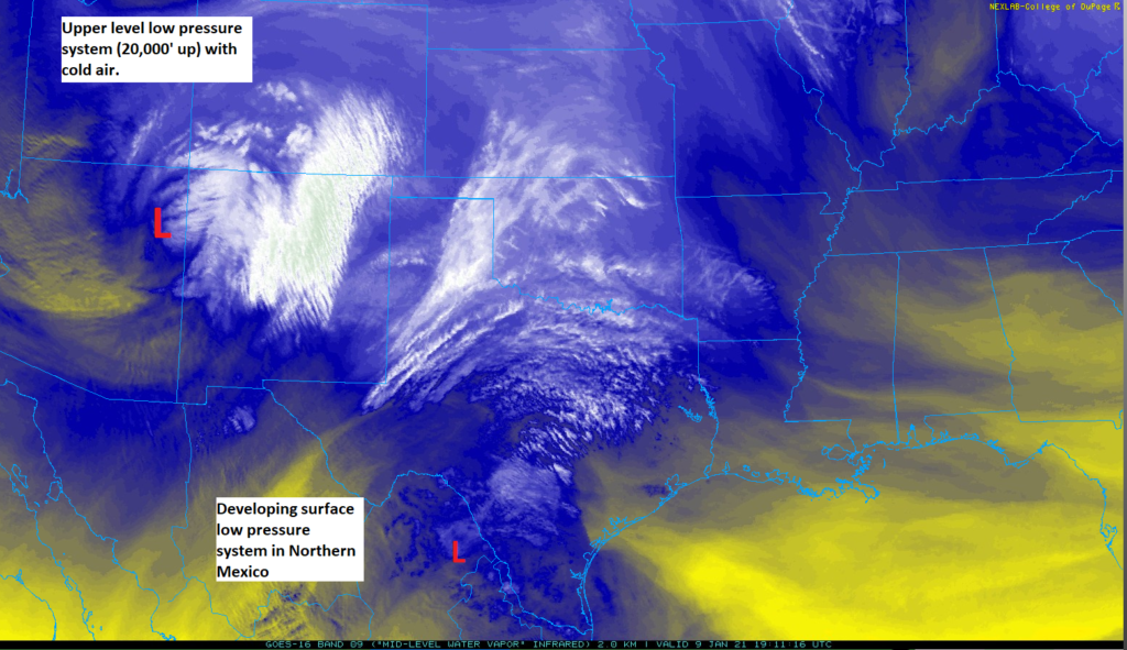
On satellite, the two features we are most interested in stand out nicely this afternoon. We’re looking at the water vapor channel on satellite, which shows us where dry air and moisture are located. Over the Four Corners region, you can see a swirl in the clouds representing low pressure about 20,000 feet up, our upper level storm. Over northern Mexico, you see moisture gathering, which is where low pressure at the surface will begin to develop. The system in Mexico will help deliver moisture and precipitation. The upper low will help deliver cold air behind a front. The combination is why we’re talking about winter weather.
Water vapor satellite imagery shows the upper level storm over Arizona and the surface storm developing over Mexico that will combine to bring snow and sleet to parts of the region tomorrow. (College of DuPage)
We still believe rain will develop tomorrow morning across the entire region. Everyone should begin as rain, as cold enough air for anything else won’t arrive til later. Look for snow and sleet to begin mixing in with the rain well northwest of the city tomorrow by early afternoon. Think: College Station, Madisonville, Crockett. The rain/snow or sleet line will continue to nudge south and east tomorrow afternoon and evening, arriving in places like Brenham, Navasota, and Huntsville by late afternoon. From there, how much farther southeast could the rain/snow line get? Ultimately it will depend on the exact track of the storm, but I expect it will get close to places like The Woodlands, Conroe, Hempstead, or Cleveland before all is said and done.
In addition to that, as discussed earlier this week, we could be talking about dynamic cooling (where the rain falls so hard, it pulls down enough cold air to flip over to snow or sleet for a time) driven snow or sleet virtually anywhere north of I-10 late tomorrow afternoon or evening. It wouldn’t accumulate much, if at all, but if you see snowflakes falling or hear sleet pinging, don’t be shocked.
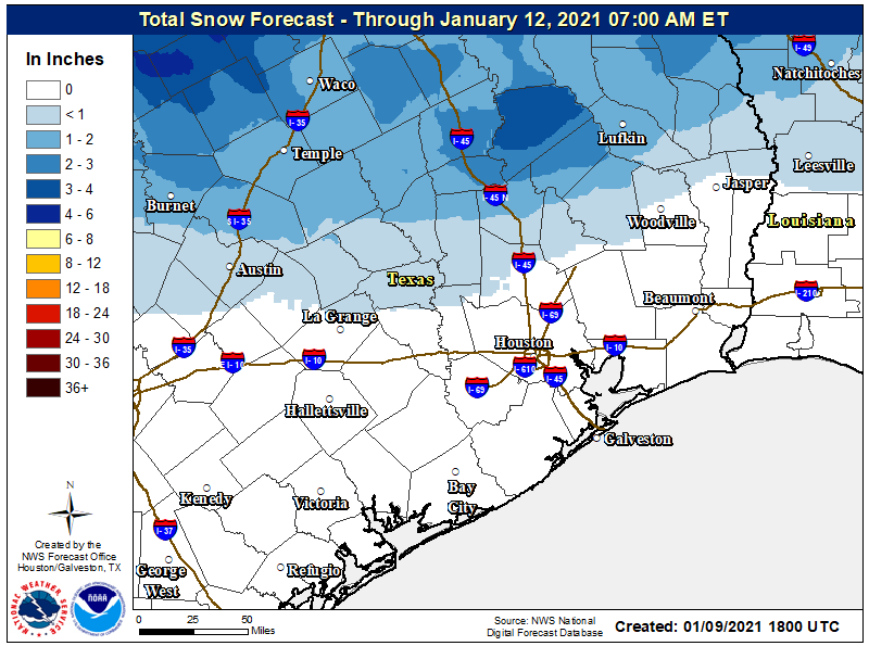
So the question becomes: How much snow for places north of Houston? For The Woodlands or Conroe, right now we don’t expect much. Maybe a slushy coating if things break right (or wrong depending on your viewpoint). However, as you go north of there toward Huntsville west toward College Station or east toward Lufkin, it gets dicey. Here’s the current forecast from the National Weather Service as of early afternoon Saturday:
Snow forecast as of early Saturday afternoon for southeast Texas. (NOAA)You can see about 1 to 2 inches for Huntsville, less as you go south, more as you go north. It is notable that there are some weather models that show considerably higher snowfall amounts up that way, up to 4 to 6 inches of snow or even more in spots.
There are two main problems in determining how much snow will fall. One is the storm track, discussed a bit above. The second is something I made a Twitter thread about earlier today: Sleet. Sleet can destroy a snow forecast. I’ve been burned many times by that. The more the precipitation that is frozen falls as sleet, the less snow accumulation there will be.
Let's look at 7 PM Sunday. Here's the 12km NAM thermal profile for Huntsville. Definitely good for snow with the entire column except the surface below freezing. pic.twitter.com/eqHSdtHUOS
And right now, the temperature profiles north of the Houston region are a mess, with a very, very fine line between a cold rain, sleet, or snow. That could mean the difference between someone seeing a coating or 1 inch or someone seeing closer to 5 inches of snow.
The GFS model at Conroe for that same time shows a very mild temperature profile with above freezing temps from about 7,000' above down to the surface. That's a cold rain. Alternatively, the NAM has a fairly substantial subfreezing layer that allows for sleet instead. pic.twitter.com/Qm0hLlmOid
That’s a big, big deal, and it’s very difficult to pin down. So forecasting how much snow falls will be challenging, but who sees the snow? That should be a little more straightforward.
If you live in the city of Houston, keep hope alive (if you want snow), but the odds are going to be quite low. If we do see snow in the city, I would target the 9 PM Sunday to 2 AM Monday window to catch a fleeting glimpse.
If you want to see legitimate snow and feel comfortable traveling: Huntsville, Crockett, or College Station are as good a bet as any right now, though not quite a full guarantee. Just keep this in mind if you do plan to “snow chase” tomorrow: You will have to come back at night, with temperatures getting colder. While it should be fine in Harris County and most surrounding counties, there may be difficult, slippery travel up north. So just make sure you exercise wise judgment, are prepared in case it gets bad, and please be safe.
Good morning. Today’s post will be fairly brief, as I went in depth rather significantly on weekend snow chances yesterday, and we will be keeping you posted this weekend. To be quite frank, not much has changed since yesterday’s post, although trends overnight were slightly warmer. But still, let’s jump in.
Today & Saturday
Not much weather to speak of over the next 24 to 36 hours. Today will see a bit of low cloud cover in parts of the area this morning give way to mostly sunny skies. Look for highs in the mid-50s. Tonight will see clear to partially cloudy skies with lows in the 30s and 40s. High clouds may dim the sun a bit tomorrow, but otherwise, it will be a mainly nice day with highs once again in the mid-50s.
Sunday
So the forecast for Sunday looks mostly on track with the big picture details being cloudy skies to start with rain developing from west to east through the late morning and afternoon. The thought right now is that basically the entire area from the coast through Conroe (Highway 105) will begin as rain. As the atmosphere cools later Sunday afternoon and evening and the rate of precipitation increases, that’s when we’ll start to likely see some snow reports begin to trickle in from places like Huntsville or Lake Livingston or College Station. It’s possible a few locations farther south closer to Houston see snow mix in if it rains hard enough Sunday afternoon.
One model (Canadian) depiction of what might be falling at 6 PM on Sunday, with rain for most of Harris County and south of I-10, but mixed rain and snow as you go north of Harris County, and mostly snow perhaps north of Highway 105. (Weather Bell)
As we go deeper into Sunday evening, watch for more snow reports to come in from places even farther south, more into Conroe or The Woodlands or Tomball out into Cleveland and Liberty. Rain may turn to mostly snow in some of those places before ending after midnight. And perhaps the rain will end as some light snow in Houston also after midnight.
Will snow accumulate? As of right now that seems very unlikely in the city of Houston and most of Harris County and surrounding counties to the west, south, and east. For Montgomery County and points north from there, yes, snow might accumulate a bit. Right now I wouldn’t expect more than an inch or two, mostly on grassy surfaces and trees, but we could see more in spots depending on how things come together. Slick road conditions are indeed possible up that way Sunday night and Monday morning.
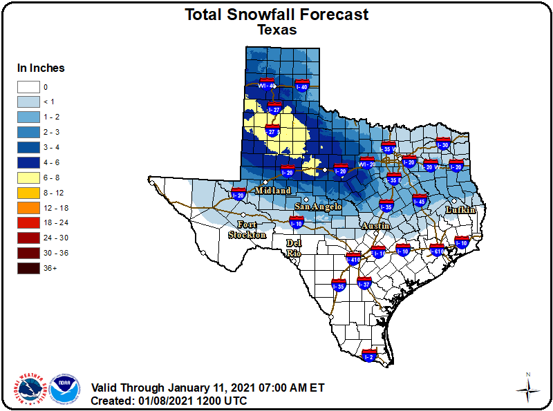
As of Friday morning, the snowfall forecast for Texas shows a wide band of 4 to 8 inches of snow to the north and west of about Waco, with snow totals dropping into the 1 to 3 inch range east of I-35. Again, this too could change.
The current snowfall forecast calls for 4 to 8″ of snow over a wide swath of West Texas, with totals dropping to 1 to 3 inches as you get east of I-35. (NOAA)
Once more, we have to underscore that because storm tracks matter a lot and a few miles can make a world of difference, there is still substantial uncertainty surrounding this forecast. Much may change by Sunday morning. We’ll keep you posted this weekend. I mean, can you tell that I’m excited by this? Has it shown at all?
Again, in addition to the snow aspect of things, there will be locally heavy rain (up to an inch in spots, more perhaps near the coast) but probably no serious flooding. Thunderstorms are possible. And coastal issues, such as rip currents, rough seas, strong winds, and even some tidal flooding will be possible also.
Monday and next week
Look for clouds to hang tough on Monday behind the storm, with cold and windy conditions. Clouds clear for Tuesday, Wednesday, and probably Thursday. Look for temps to rebound into the 50s and eventually 60s. Morning lows in the 30s Monday morning (and perhaps a freeze north of the city) will rebound into the 40s by midweek.