Last week, we discussed how 2020 had started off tremendously fast but slowed a bit. We’re coming out of that lull now, but thankfully what we are amassing is mostly curiosity rather than any serious impacts.
Tropical outlook in a sentence
While another system is possible off the East Coast, the Gulf is not expected to deliver any action over the next 1 to 2 weeks, as summer roasts much of Texas.
Edouard sets another 2020 superlative
With Tropical Storm Edouard being named on Sunday night, the Atlantic has now set a new record for the earliest 5th storm on record. The previous record holder was Emily back in 2005, which formed on the 11th of July. We typically do not see our 5th storm until the end of August, so we are off to the races right now. We’ll discuss 6th storm records in just a moment.
Again, there’s a huge difference between utilizing number of named storms and accumulated cyclone energy (ACE) to characterize the start to a season. Please see last week’s post for an explanation of the value and shortcomings of ACE. From the named storm standpoint, we’re at late August levels already. From an ACE standpoint, we’re at July 20th levels, not super abnormal.
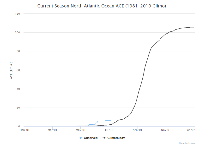
Just to put this into a little perspective: In 2005, the year we keep beating for earliest storm, by the time the 5th storm dissipated on July 21st, we had amassed an ACE of 56, or what is normal for September 14th. As I’ve told some people, 2020 thus far is about quantity, not quality.
East Coast bias
Of this year’s five storms so far, four of them have formed near or off of the East Coast. Could our next system come from that area? It very well could. A disturbance dubbed “Invest 98L” moved ashore on the Florida Panhandle on Sunday night. It is currently over northern Georgia and projected to lift to the north and east over the next few days.
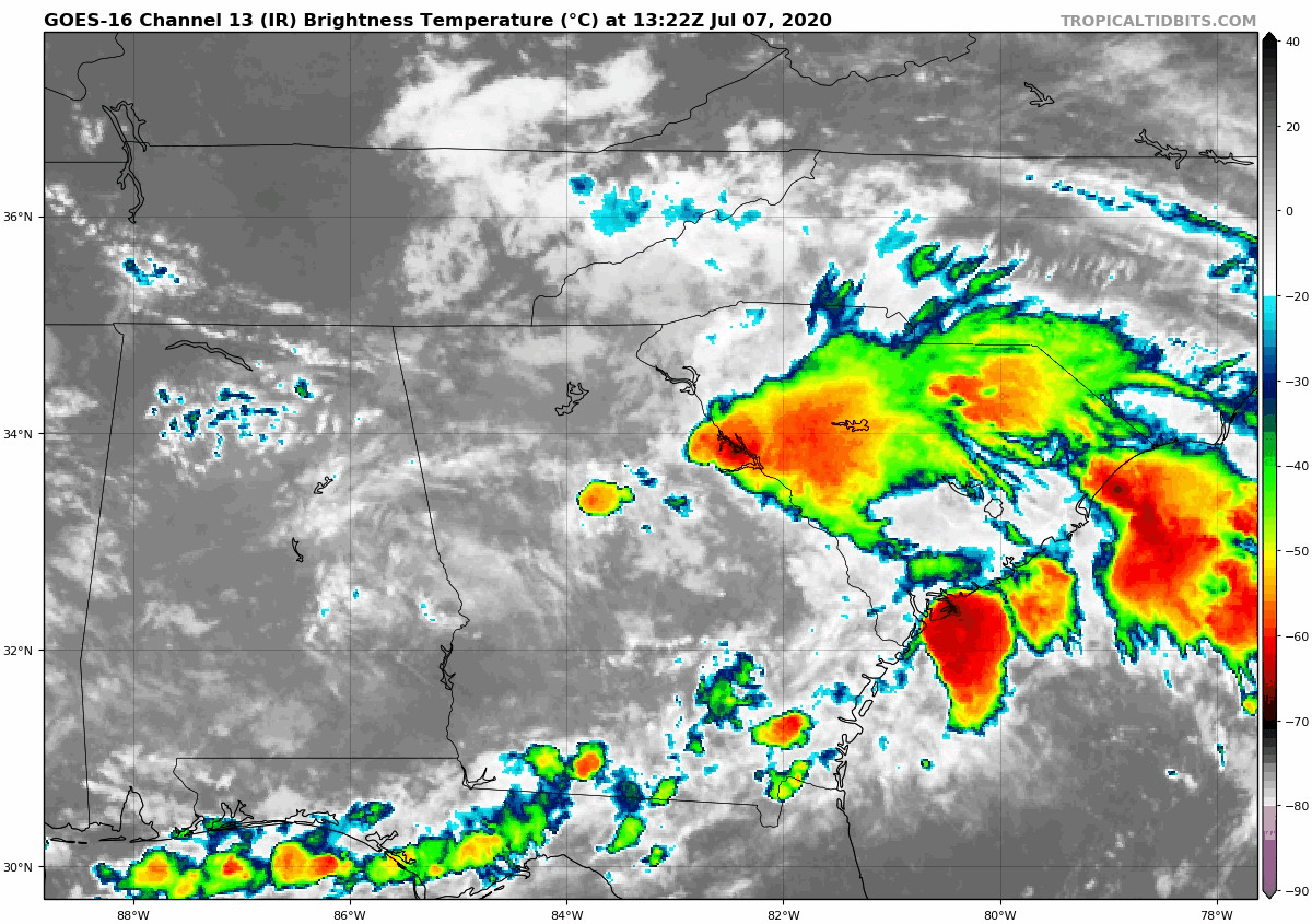
Right now, the National Hurricane Center is giving this about a 40 percent chance at becoming a tropical system over the next few days as it lifts north and east off the East Coast. If it does become a tropical storm, it would be named Fay, and it would break the record for earliest 6th storm (Franklin on July 21, 2005). This disturbance should produce heavy rain on the coast of the Carolinas, but at this point, it is not expected to cause much serious trouble before rolling out to sea.
Saharan dust
We continue to see the bulk of the Atlantic basin littered with dust today.
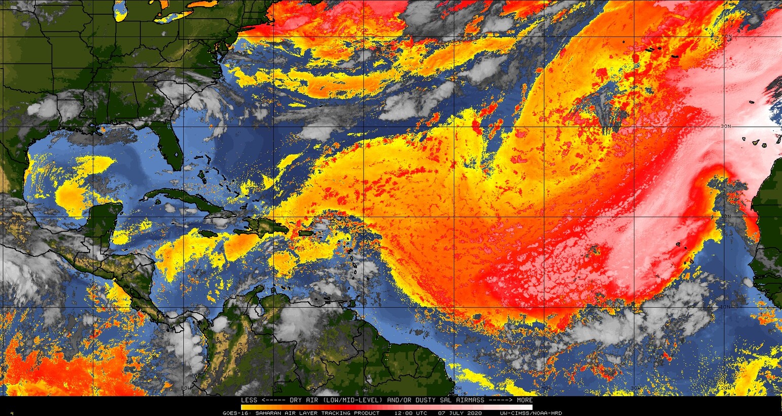
Dust, while widespread, is beginning to ease up a little relative to late June. The good news for us in Texas is that the quantities of dust reaching the Gulf are slowly diminishing, so we’re not expecting quite as ugly of an impact from dust over the next 10 days as we saw in late June up through this past weekend. Still, as dust rolls west across the basin, it’s always possible we see some in our area. But we do have something extra working in our favor by this weekend.
Heat in Texas keeps the Gulf closed
Look, some of us like the heat this time of year. Many of us deride as just something we have to accept about living here. Sometimes the heat can be good for something, and in our case, it would seem that it will help shield us from any Gulf happenings, including Saharan dust over the next week or two. To be clear, we don’t really expect any Gulf happenings, but in the off-chance something could form, strong high pressure over Texas would most likely deflect anything back to the east or well south into Mexico. Below, you will see the GFS ensemble mean forecast for days 6 through 10 (Sunday to Thursday next week), which shows high pressure in the upper atmosphere oriented just right to keep Texas protected.
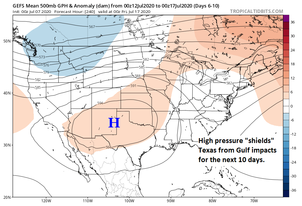
Of course, that will come with a cost, assessed in triple digit temperature risk and heat index values. But as long as high pressure can hold over Texas, we’ll be pretty safe from the Gulf. We don’t expect that to last forever, but for the next week or two, it is expected to be quiet, albeit dry.
Our weekly tropical roundup is Powered by Reliant.

I’ll take the heat as long as it keeps the tropical stuff away. My A/C is working just fine, that is unless power got knocked out by a hurricane !
Appreciate the clarity and informative comments, without hype and slant
Always read your details, calmly. Thank you for a friendly delivery of forecasts.
Matt,
Love you guys, and love your openness, and love how you do what you do. You and Eric. I am opining because I was gobsmacked by the statement “…Carla most powerful blah blah…” Drove me Bat KAKA crazy. Do you realize that in 1987, I could drive through Hattiesburg and Laurel, and still see the loblolly pines permanently bent to the northwest by Carla’s winds?
1900 storm? 1915 storm? 1935 Key west storm, taught in meteorology classes as an insanely powerful storm that lifted steam locomotives and their loaded tenders (~130 tons) off their tracks… Camille… Not one building standing within a couple of miles of the coast. I remember flying over Biloxi, and the cap on the PA pointing out a several thousand ton ship stranded one mile or so inland…
You know that we can see sunspots that were invisible just 50 years ago. And all of y’all are counting storms in the open ocean that we never saw before, not unless they hit land, somewhere.
And then, we only knew their path by by the islands they had hit… We never knew about them until they rammed their way into the Caribbean…
Our ability to see storms in the open ocean dates to about 1970, possibly spotty data in 1969. Carla hit a sparsely populated area of Texas, that in 1961 was neither well monitored, nor recorded. Are you reporting modeled data? This is not a matter of supposition. Are you able to tell me how many anemometers reported readings from the storm from Freeport, Matagorda, etc.? What were the actual readings? Have you access to verified original records from those weather stations, be they Stevenson screens or what not? Where is your data coming from?
I can remind you that the Pass Christian, Biloxi and Gulfport anemometers stopped reporting their wind speeds at around 200 miles an hour, steady blow… Come on! man!
Bent to the North West by Camille’s winds in 1969. NOT CARLA’S Typo
The Mississippi coast anemometers stopped reporting because not one station within sight of the coast had any instrumentation left, if I remember correctly.. Jeez, it’s been 61 years next month.
I guess hi pressure heat shields us (Texas) from Gulf happenings from coming to our shores.