11:15am CT Tuesday: For much of the last 24 hours a rain band of at-times broken storms has tracked upward along the Interstate 45 corridor and then more or less curved left, following the South Sam Houston Tollway. This has dropped about a foot of rain on Pearland and Missouri City, and nearly as much in other communities adjacent to the Gulf Freeway and on the south side of Houston. Some bayous are at bankfull, and others have overtopped their banks. Roads are a mess.
Over the last couple of hours this band, and the strongest inflow of moisture from the Gulf of Mexico has shifted somewhat east, coming across Galveston Bay and into Baytown. These areas have been relatively untouched by Beta’s heaviest rains over the last two days, and can generally handle the rainfall.
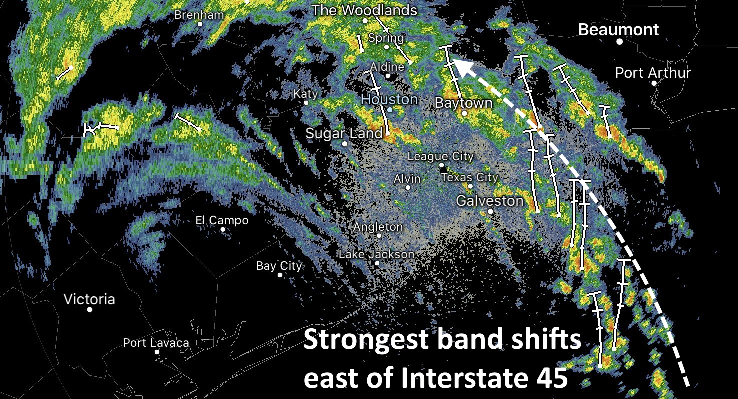
As a result of this shift, the hardest hit communities south and southwest of Houston will see more sporadic, less intense showers as we head into the late morning and, presumably, early afternoon hours. The question is what happens then? Our high resolution forecast models have not performed great, but right now there is a general consensus that this trend will hold. While the greater Houston area will remain at risk for heavy rainfall for the rest of today, by this evening or Wednesday morning the bulk of the activity should shift east of Interstate 45.
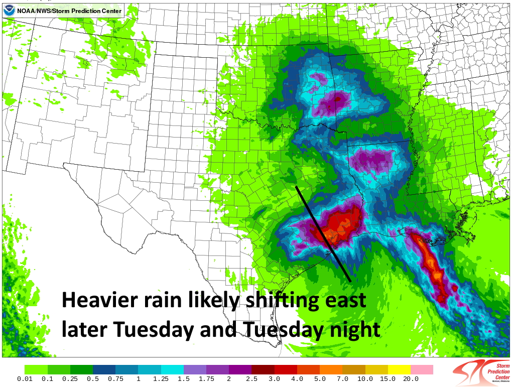
So cautiously, I would say the worst is probably over for areas southwest of Houston, including Sugar Land. That may become increasingly true for Pearland and hard-hit communities along the Gulf Freeway as well later today and tonight. Whether that means those areas will pick up another 1 or 3 inches of rain is not clear. This is all subject to change, of course, but at least it does seem consistent with radar trends and the overall setup of the atmosphere.
Our next post will come no later than 4pm CT Monday.

Hooray..(at least for now).
Thanks, Brays Bayou is receding for us in Bellaire (@1120 hrs). 24-hr rain period of ~12″ at 430 Brays Bayou @ Stella Link Road.
Thank you for keeping this website up. It’s a huge help.
What does the E Harris/Chambers/Liberty area expect for the next 24 hrs? Will rainfall abate as the bands move E over the next day or so, or will we see relatively same amounts of precipitation?
We hit almost 4″ per hour rainfall rate about 5 AM this morning. Just had a break in the rain to be able to walk the garden – we’re waterlogged here in Montrose, but we’re draining. 8″ so far today, up to 12″+ since Sunday.
Is Texas City near Mall of the Mainland considered East of I-45? Thank you.
The Mall Of The Mainland is on the east side of Interstate 45. Texas City on the same side of the Mall Of The Mainland is considered East of Interstate 45. I hope this helps. Good Luck.
Is it East of I-45 on a map? If so, then yes it’s considered East of I-45.
Thanks for all your hard work guys. Pesky thing for sure. I’m guessing if this hits in August…we’re singing a little different tune. Here on Bolivar…quite a bit of beach/dune erosion and the usual closure of Hwy 87 and the Ferry.
You guys have a super forecast; the best around Houston
What do you estimate for Crosby area for the remainder of the event?
Can you address the impacts on the Kingwood Humble area? Many of us have storm PTSD due to impacts from Harvey & Imelda. The little week long rain event that we experienced a few weeks before Imelda took out 7 trees in my yard and one of our teachers lost her life when she drove into a downed tree. Even if it’s just reassurance, it would be welcome. Thank you for your no nonsense timely updates.
13+ inches in 24 hours — 8″ in the last 12 hours — at Willow Water Hole near Westbury but stops and starts have made all the difference.
I really like reading Eric and Matt’s updates.
Simple, here is what we have, what we ‘should’ expect and not fear !
YAY!!! The Willowbend/Cliffwood area has been pounded, and I was so upset this morning that I kept nerve puking. But it does look better now. I actually ventured out to the neighborhood Foodarama and picked up a few groceries (and some wine!). And when I returned to my car, the sun had come out! Thanks for all y’all do!
Oh Vicki, I can relate! I grew up on Cliffwood in Willow Meadows and went thru hurricane Carla over there when I was a kid…this was well before the 610 loop that I believe runs right thru that area now. More concrete, more prone to flooding. Prayers for you and yours family…🙏🏻🙏🏻🙏🏻
It seems these storms really like the I-45 corridor!
Looks like this one didn’t “exit stage right” as mentioned previously. It broke a leg. Thanks for the updates overall.
Piss off with the sarcastic, passive-aggressive stuff. You were inatructed regarding what a slower moving storm could so. Learn something and move beyond your degenerate-hick self.
Regardless of the rainfall amounts, we really dodged a bullet!
Looking at the satellite and infrared from around noon, Beta is looking like a mess. The sun was coming out around here, too.
We need the moisture
Hmmm, the NWS is showing a near 100% chance of rain beginning around 7ish and dropping another 3+ inches. We’ll see if that pans out…
The typical great job ! Thanks guys !
How we looking for spring /aldine area fm1960