4 pm CT Tuesday update: We’re starting to get a better handle on the forecast for the rest of today, tonight, and Wednesday when it comes to the potential for heavy rainfall. The good news is that we’re reasonably confident that this mess will begin to clear out of here by Wednesday morning, if not sooner for some areas. The bad news is that we’ve got to get through later today and tonight.
Beta synopsis
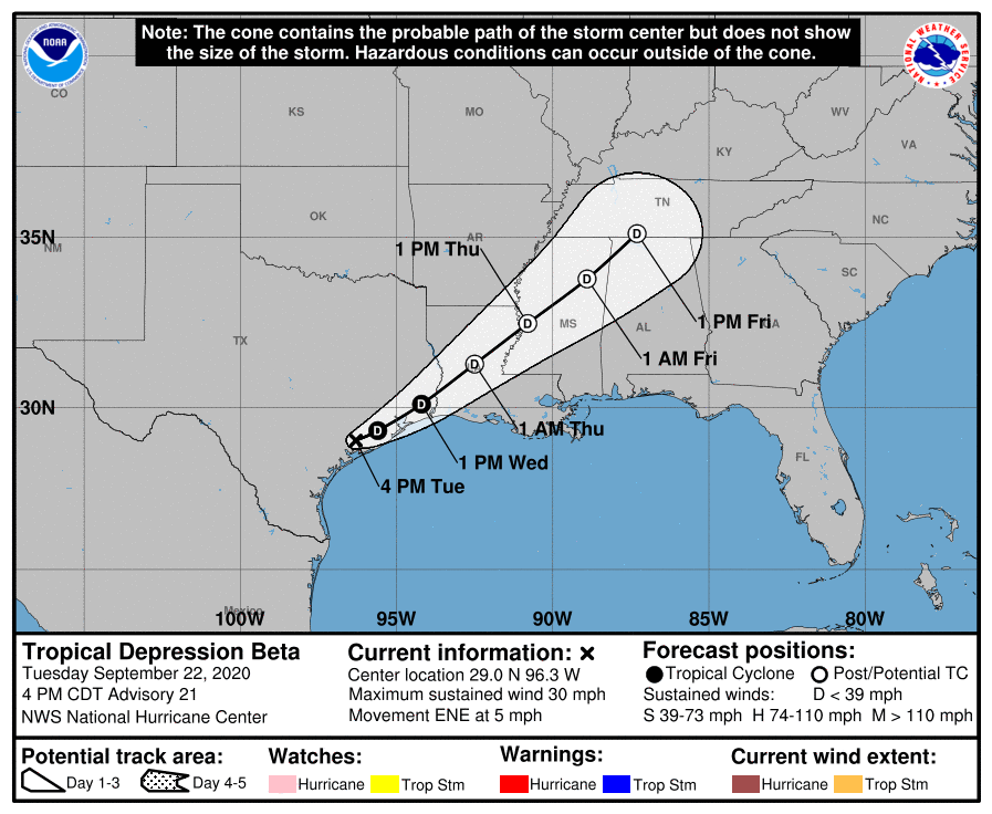
Beta is now a depression, with sustained winds of 30 mph. In its 4 pm CT advisory on the system, the National Hurricane Center notes that its speed to the northeast has increased a little bit today, from about 2 mph to 5 mph. This speed should increase further over the next 24 hours. The storm’s “center” will pass across the Houston area on Wednesday, probably before noon. Its passage should be imperceptible.
Tuesday evening and Wednesday morning
As anticipated, the radar cleared out over much—although not all—of the Houston metro area earlier this afternoon providing a reprieve for southern regions after more than a full day of rain. Aside from Clear Creek on the southern side of Houston, most bayous are within banks at this time. The Clear Creek watershed, by contrast received some of the heaviest rains and some home flooding in Pearland and Friendswood has been reported today. Based upon current levels, it looks like flooding along Clear Creek can be classified as a 10-year flood, although that will have to wait for a post-storm analysis.
As the remains of Beta move northeast, we anticipate the storm’s circulation will draw additional moisture in from the Gulf of Mexico, and form new rain bands. These will likely produce training over the region (at 4pm CT we’re seeing this from downtown Houston up Highway 290). Most model guidance suggests 2 to 6 inches of rain over these areas, but the National Weather Service has indicated a risk of some areas seeing 10 inch bullseyes.
At this time it appears the heaviest rains tonight will probably miss hard-hit areas in Fort Bend, Brazoria, and Galveston counties—they may go further north. However, it’s going to be close. For example, and take this with a grain of salt, here is a 12-hour rainfall forecast from the HRRR model showing accumulations from 4pm Tuesday through 4am Wednesday.
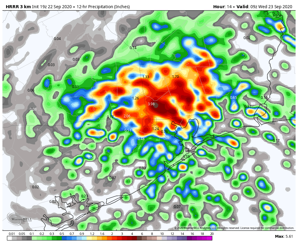
Beta is a messy storm and unpredictable, so this is just one forecast and far from gospel. Still, this model (and others) indicate the heaviest rains during the next 12 hours will probably stay north, and current radar trends support the idea that high rainfall rates will be most prominent across north, northeastern Harris County and into Liberty County.
Were such rain totals to come further south into Harris County they would pose a big risk to areas like Meyerland and Westbury, which have recorded in excess of 10 inches of rain over the last 24 hours. However, we have seen some good falls in Brays Bayou today which are continuing. So a few inches, which is our current expectation, are probably manageable, but 10 inches would be pretty bad.
As Beta continues to slog to the northeast, most model guidance shows the precipitation exiting the western half of the metro area by around midnight, or the wee hours of Wednesday morning; and exiting Harris County by around sunrise or shortly thereafter. By the middle of Wednesday morning the focus of heavier rainfall will probably shift toward the Beaumont area. So it looks like we have about 12 to 18 more hours to battle with Beta. Is anyone else sick of this storm?
Our next update will come by or before 8 pm CT Tuesday.

I want to thank you and all of the local weather people on TV for giving accurate forecasts during every severe weather event. Most people don’t like the local weather forecasts because of apparent “fear mongering” which I have never heard during ANY TV forecast, but I like to use multiple sources for my weather news and not stick to just one source.
Rachel
What city are you watching local weather from? And do you have the volume on?
Houston and yes, I do.
I just don’t buy into the “the weather people on TV are always trying to scare you” thing. Not everything they say during major weather events is meant to scare you.
It’s all about how you interpret what they say and not get too worked up about it.
I have noticed a major shift of tone from the local stations over the past year or two, especially since Harvey. One the region still has stress issues due to Harvey, and likely will for a long time. Two, I want to call it the space city weather effect. The producers are learning that there is only so far you can go with the biggest and baddest, and eventually you scare everyone into hiding or turning off, and people were turning the channel. When they found out that being told, we don’t know or here are the probabilities of events that may happen, is a positive to people, they have been shifting their tune. The shift in channel 2 is remarkable. They used to slap an adjective non every raindrop and now stop. It is welcome relief.
I really think a lot of it is these guys. The local media has certainly started to seem more objective as Eric and Matt have gained a little more popularity. Correlation vs causation but it is a welcome improvement.
sunrise, instead of sunset? in the last main paragraph?
Thanks for the updates Eric, they have and are invaluable! The no hype reporting is great!
It has rained on me in Montrose ALL day. I had maybe two breaks for ten minutes each and then pick up again. I really dislike the closeness with which the water approaches my door each time.
And thank you very much for your hard work. It definitely helps me stay informed and not (overly) panicky.
So tired of the storm you are waiting almost a week to do the next update? Or did you forget that today is Tuesday. (Happens to me too)
He will update again tonight at 8pm.
Sorry — been doing this all day with regard to confusing Tuesday for Monday. Fixed now.
My daughter is trying to get home to Baton Rouge. Is it better to leave today or wait until tomorrow?
Excellent forecast. Thank you.
Texted my boss at 7 AM to say I was taking the day off. Later after 8 when I would have been at work, they announced all locations closing and delayed opening Wednesday. Glad I stayed home. May do that tomorrow too.
Thank you….you just give so many the comfort we need….
“Is anyone else sick of this storm?”
I’m sick of living in Houston, period. Dodging floods and hurricane-force winds is reason #1. As is having it 100 degrees for 100 days each summer. That’s also reason #1.
Amen!
Sorry you don’t find houston to your liking. Plenty of roads heading north, but then you’d miss out on days like last week’s cool and breezy CoC standouts
Thank you for your diligent reporting of Beta.. you are my lifeline to the weather…!!
I feel bad for the folks that have flood issues but I welcome this rain. Its been really dry all summer long here in the 77095 area code.
Ah yes, the annual “10-year flood” 😕
Well, at least it isn’t one of our annual 100-year floods.
I’m thinking they should have called this one Zeus.
I agree with props for local weather guys. With great radar technology, they really “paint the picture” quite well on the tv side. (And we obviously have the electronic version in A+ form with Eric and Matt). Must say I’ve amazingly come to hitting Ch 2 first for big weather events. Ch 11 and David Paul used to be my “A”, but losing Brooks Garner was a huge loss (and it so, so shows). Kinda akin to what Astros will experience next season when FA’s Brantley, Gurriel & Springer have departed…
You forgot Correa (might not be marketable due to being injured half the time) and the impending Verlander retirement.
I cannot believe how much I enjoy your weather reports, Eric & Matt, even when the news is bad 😜. In the meantime, all this rain is killing my new lawn. Next could come the sod worms 🥴