So I just wanted to freshen up the site with a quick overview of what’s happening this evening and table set for tomorrow morning, when we should begin to give some more confident answers on impact risks to our area.
Now
I want to point out some of the key features to watch on a water vapor satellite image.
First, over the Desert Southwest, you can sort of see yellow color lifting north slowly. That’s the ridge of high pressure which will play a role in steering presumed future Barry. To the north, over Minnesota and Iowa, the yellow color beginning to dig south and east represents a trough in the upper atmosphere that will act to try and “pick up” Barry, drawing it to land. The ballet between these features, combined with where the storm eventually coalesces will determine whether this is indeed a Louisiana storm, as most modeling suggests, or if it could make its way far enough west toward Texas. We will learn much more about this overnight.
Where is that center?
Well, according to this tweet from one of the hurricane hunters, it’s still too broad to be easily defined:
We found a broad circulation, but fortunately not yet much else to see but a few showers and a lot of oil rigs! https://t.co/U4N51r0IJz pic.twitter.com/GILfThYeb7
— Jeremy DeHart (@JeremyDeHart53d) July 11, 2019
Based on the most recent observations from the aircraft out there this evening, however, they may finally be on to something near 27.5 N/87.5 W, or a little bit south and east of where the National Hurricane Center had been initializing things. If that is the case, that would not be drastically farther south than expected, meaning I would feel a smidge better about the “miss Houston to the east” scenario being realistic. That said, strange things can happen overnight, so let’s watch and see what’s what tomorrow morning.
Evening models
A new batch of modeling comes out in the evening that we don’t use a ton, but we can still use to look for trends. Indeed, those models did trend back to the west a bit, but not as far as it looked this morning. What does this mean? Model consensus is still very much pointing toward a Louisiana landfall, keeping most impacts to our east. Thus we have no issues with the official forecast from the National Hurricane Center.
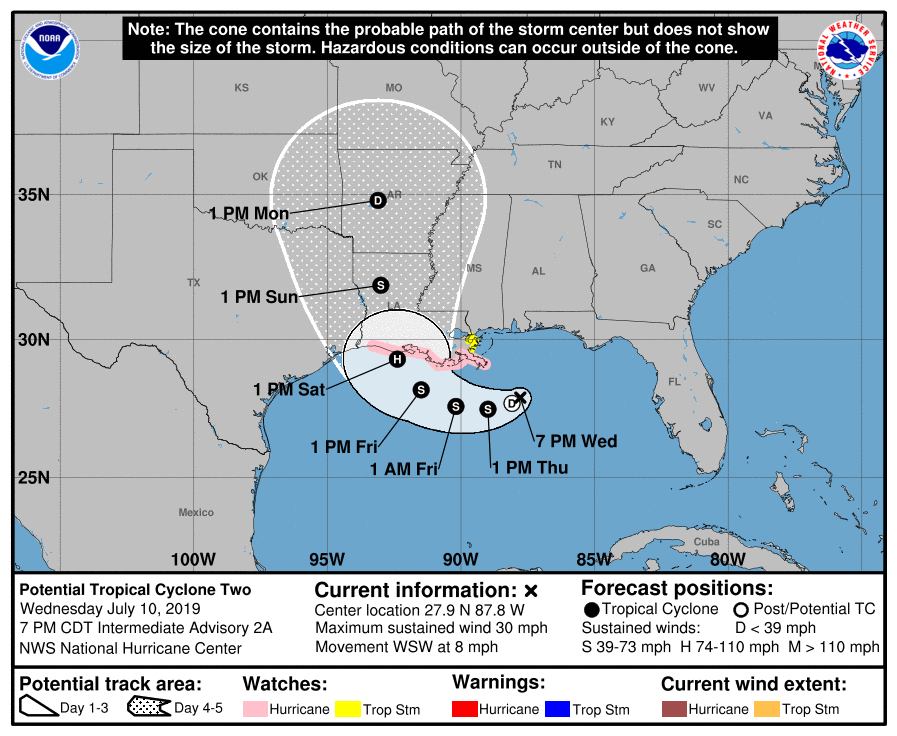
The NHC forecast for “Potential Tropical Cyclone Two” shows landfall between Cameron, LA and Vermilion Bay, but the cone obviously extends further to the eastern side of Houston on the left and east to near New Orleans on the right. Hurricane Watches were hoisted late today, extending from Cameron, LA east to the mouth of the Mississippi River. I would expect a tropical storm or hurricane watch to be extended west overnight, perhaps all the way to High Island, TX (northeast of Bolivar).
One word of note: If you have friends or relatives in the eastern half of Louisiana or your travels will take you through there between late Friday and Sunday morning, please make sure everyone is staying on top of the latest with this system. This has the potential to be a very serious rain and flooding event for that region, including Baton Rouge and New Orleans.
So for folks in Houston: You can go to sleep tonight knowing that no data this evening has increased our odds of being significantly impacted by this storm. But given a lingering degree of uncertainty, you absolutely will want to check back in on the forecast tomorrow morning to see what, if anything, may have changed overnight.
Eric has you covered in the AM, and I just want to offer him a mention of gratitude for stepping up to spell me so we can maintain continuous coverage through the storm.

You guys are the best! Thank you so much for all of your hard work in keeping us informed!
Thank you for keeping us informed. I always feel better when I read what y’all have to say because it’s reliable and sound.
Thanks so much for the interesting update. Just found you few days ago. Appreciate your efforts.
Thank you so much for the latest news on this storm now I can sleep a little hoping even better news in the early morning.
You forecast is the only one I trust. Thanks for posting so frequently.
Thanks for the updates! It’s looking better for us, worse for our Louisiana neighbors. Still seems like mostly a rainmaker though? I’ll be happy to sit this one out!
Thanks for the update!
Thank you both so much!
You guys are the BEST! Thank you for all the reliable and no-hype updates, Happy Birthday to Eric’s wife! So sorry your vacay was interrupted by Barry!
I really appreciate your work. Thank you.
Thanks, really appreciate what you all are doing
Thanks for the update. It is always good to know “this is what we know now and here are the possiblities” No hype. Just the facts.
so grateful for you both and your commitment to the facts as you and science sees them-
You guys rock. Thanks Eric for interrupting your vacat a bit for us!
Thank you! I heard in passing about this weekend’s weather.
Thank you both. My heart goes out to the people who will experience this storm. I no longer feel relieved when I learn it will “go the other way” as I know someone will be negatively impacted.
Love you guys! Only weather people I listen to. Thx so much for your hard work and patience explaining the weather to us in such easy to follow ways.
Thank you so much for all that you do!
I follow you more so than the news. I learned you two tell more of the truth. Thank you both so much for all you do.
Thanks for the interesting info and the no hype. I hope Eric and his wife are enjoying their trip.
Danger zone!
At least it isn’t Cyborg Barry…
I am supposed to be traveling to Kenner (next to NOLA airport) Friday early and coming back late Sunday. At this point should I still be in wait and see mode or would it be crazy even to consider it?
Thank you both for the weather news, I have followed you both for the past few years as the only reliable news that is accurate and with no hype attached.
Thanks as always. If I could offer one observation respectfully: Given proximity, industry relationships due to oil and gas, and migrations post Katrina, I’d venture to say that A LOT of us in greater Houston have friends and family in Louisiana. We are not “resting easy” at the idea that it’s “over there”. Please consider that many, many of us love our neighbors and are interested in the same “no hype” approach / commentary for areas east that may be impacted.
Thank you so much for the details. I check on the weather here everyday. In flying home from NY I have a degree of security flying over the area late this afternoon.
Thank you for the no hype details, Matt. I appreciate your explanations of the things that steer the storm. And a big thank you to Eric for helping while on his vacation in France.
❤ #SpaceCityWeather
Thanks for the continued updates on “Barry.” We planned to travel on I-10 through Louisiana on our way to Florida on Saturday. We will delay to Sunday. As we get closer to Sunday, please comment on the conditions on I-10 if you know them. Thanks so much.