Good morning. As of 4am CT, the system in the Gulf of Mexico has nearly organized into a tropical depression (named Barry), and likely will become one later this morning or early this afternoon. While Texas isn’t entirely out of the woods, as there remains some uncertainty in the track and intensity forecast, this increasingly looks like a threatening situation for Louisiana. Because the state is next to Texas, and we have received so many questions from people living in, or traveling through Louisiana, we will continue to offer comprehensive coverage of Barry as the storm develops. If you’re living in Houston, please continue to pay attention to forecasts for the next couple of days, as tropical weather invariably offers up surprises. However, it’s probably safe to go about your business as usual this weekend.
Track
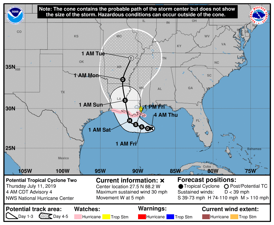
Confidence is increasing in the forecast track for a couple of reasons. First of all, we’re now likely only about 2.5 days away from landfall (likely along the Louisiana coast between Lake Charles and New Orleans), and errors for such a storm are typically less than 100 miles, even given the uncertainty with Barry. Secondly, although Barry has not yet formed a distinct center of circulation, there is nonetheless a decent clustering of ensemble members of the global models around such a solution. So a Louisiana landfall is likely for Barry, but not a certainty.
Intensity
Because Barry has not yet organized into a tropical storm, and perhaps only has a couple of days remaining sufficiently offshore, this should help to set a limit on its intensity. The official forecast still brings Barry to minimal Category 1 hurricane status prior to landfall, but confidence isn’t particularly high.

Texas effects
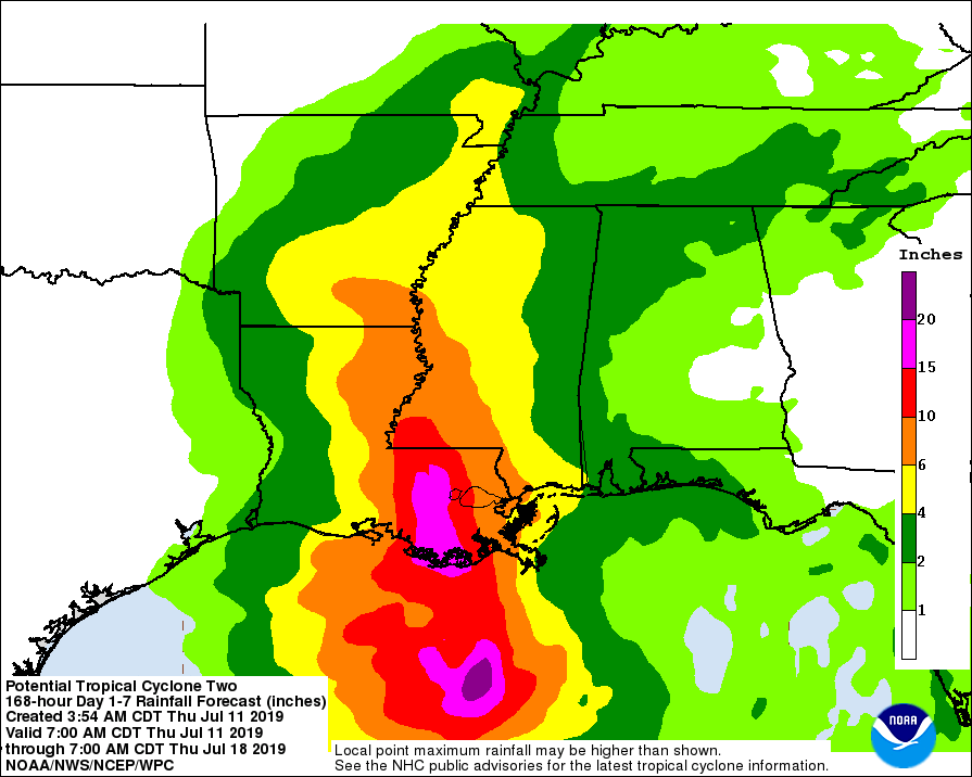
If this forecast holds, most of Texas will not see significant effects from the tropical system. This is because most of the action—heavy rainfall, storm surge, winds—will likely occur on the right side of the storm. This is due to the counter-clockwise rotation of tropical storms. The latest forecasts suggest that most of Houston will probably see 0 to 1 inch of rain, with higher potential amounts in Galveston and along the coast. The latest modeling indicates that even areas as far east as Beaumont and Port Arthur are unlikely to experience more than 1 to 4 inches of rain from this system; although again this is subject to change should Barry follow a more westward track.
Louisiana effects
The state of Louisiana has already received significant rainfall from this tropical system, with up to 10 inches of rain falling in the vicinity of New Orleans. Flash flooding and river flooding are likely in parts of southern Louisiana beginning later Friday through the weekend. We have gotten lots of questions about travel through the state; our best advice is to check roadway conditions before leaving, and to seek alternate routes such as I-20 through northern parts of the state. Saturday is probably the worst travel day.
In regard to storm surge, while there are some concerns about over-topping of levees on Saturday along the Mississippi River in the Lower 9th Ward, Algiers and St. Bernard Parish, local officials with the U.S. Army Corps of Engineers believe they can manage surge levels. Water levels are expected to run 3 to 5 feet above normal on top of an already high Mississippi River due to floodwaters draining from the Midwestern United States.
Thank you so much. Praying for all our neighbors in Louisiana.
It seems you are fairly sure that Houston will not see more than 2 inches of rain based on current data projections. But whats the likelihood of the storm shifting direction, say a 100 or 200 miles more west? Is it possible or can we relax entirely?
Also, I remember Allison making a few rounds around the gulf. Is that possible here too?
Thank you sir!
Eric mentioned this under TRACK: “… errors for such a storm are typically less than 100 miles, even given the uncertainty with Barry.” So while it is possible that Barry could take a more westerly track, it is very unlikely. Anything is possible (never say never) but the odds are against it.
FWIW, my “weather gurus” Eric and Matt have put me at easy concerning Barry. I’ll keep looking to see what it is doing but right now we don’t have plans on leaving the area. A family member has an unusual medical condition and we can’t be without electricity for any length of time. So we leave the area early and way before anything hits. We’re not packing yet.
Having said that, no one really knows. With 20/20 hindsight, we should have left due to Harvey. Our house didn’t flood and we always had electricity but it was a close call. By the time we decided it was time to go, we couldn’t get out because most of the major roads were flooded. Based on my totally inaccurate garden rain gauge, we got way over 40″ from Harvey.
Thanks. I wish I had read it as well as you clearly did. Thanks 🙂
Thanks for mentioning Beaumont and Port Arthur area. I have folks out there!
We have a trip planned to New Orleans next weekend, the 19th-21st. Is the flooding in the French Quarter bad enough that we need to start making other plans?
The French quarter is high ground in the city. That’s unlikely to get affected by any flooding unless the whole city is under. It didn’t flood in the French quarter during Katrina.
Canal Street @ Bourbon St was under water yesterday. Are you saying the rest of French Quarter would not flood in this situation? I’m just asking because I know nothing about the demographics but I saw the pictures yesterday.
Ugggh, if Canal at Bourbon is under water that’s two blocks from where we are staying and at the entrance to the best place on earth
However, the people who work in the French quarter may live in affected areas and not be able to come in to opens shops and stuff. I have seen this happen during a bad tropical storm.
Thank you for always giving us true details & predictions, unlike the fear mongerers on the major news broadcasts.
Texas and especially Houston and now Louisiana are the luckiest people to have you and Matt on the watch. Thank you both
Good morning! Thanks for your continued coverage of this storm and others. There are many people who benefit greatly from y’all’s knowledge and the format that this information is available in. Keep up the great work!
I would almost rather it hit here than New Orleans. We can handle a weak storm at this time, they cannot. The Mississippi River is on the verge of topping its levees, this is uncharted territory for our neighbors.
It appears the winds are out of the North this morning and cooler, slightly drier air. The one minor benefit of being on the west side of the storm.
Thank you for all you do! Appreciate the info and keeping watch still.
Thank you Eric and Matt for your continued work.
And also a thank you to Eric’s wife. My wife knows what it’s like to have me ripped from our festivities when a work thing comes up. And she isn’t always the happiest about it. We appreciate her sharing you with us.
Thanks for the accurate information. Always rational and always calming. Great job!
Great Job. Thanks
While I do watch the weather forecasts on the local television channels, I rely much more on Space City Weather. The television meterologists don’t provide the in depth information provided here.
Not to mention the the media uses scare tactics when they cover these types of events. For the most part I find outlets such as the weather channel just worthless because of all of their doom and gloom over the top reporting. I just want the facts and not their scare tactics For the most part I find outlets such as the weather channel just worthless because of all of their doom and gloom over the top reporting. I just want the facts and not their scare tactics.
THANK YOU SO VERY MUCH GUYS FOR EVERYTHING!!!
You are the best and so many people depend on You
Thanks again!!!
Thanks for the cogent analysis and timely updates. I feel a bit better about the upcoming weekend than I did yesterday. Will definitely be keeping a weather eye out for changes in conditions and the storm’s track.
Another night another day, and once again “almost Barry” is extremely disorganized with convection no where near the center. This thing is now running out of time and real estate. Wouldn’t it be interesting if it never gets named only to have the next storm take the name instead… would probably cause a lot of confusion since the media prematurely named this one.
It’s just the timing, being fairly early in the season as well as a slow news week. A lot of people don’t remember 2016 when much of south Louisiana received catastrophic floods from a similar tropical wave that was never even a depression. It caused billions in damage, but it was mid Aug in a crazy election year and received very little media attention.
Looking at those spaghetti plots of the GFS and European models, a couple of straggler runs have the system meandering toward Houston. The UKMet also is more bullish about a westward movement. I assume the experts have reason to discount those runs and the UKMet, leaving Houston out of the cone of uncertainty…
https://www.weathernerds.org/tc_guidance/storm.html?tcid=AL02
If you look at upper air charts and the GFS and ECMWF models through the weekend, at most levels of the atmosphere, winds across SE Texas, southern Louisiana, and southern MS and AL are all northerly and northeasterly. So why in heavens do these models insist what might become Barry will turn and go north against these winds to make landfall somewhere in Louisiana?! Upper air patterns absolutely do not promote a northerly capture in the usual sense we often see later in the hurricane season with an approaching upper air trough.
If I didn’t know any better and never saw the predicted Barry tracks, I’d be saying this is more a Corpus Christi tropical storm than a Louisiana tropical storm as it rides under the significant high pressure ridge over the SW US!
My money is on the UKMET track at this point. I don’t see Barry being able to turn into that Northerly shear that is eating his northern half up.