Just a quick afternoon update to note that the forecast for Tropical Storm Barry has not changed appreciably today. While it shows some signs of getting its act together, the strongest winds remain far from the storm’s center. As of 4pm CT maximum sustained winds are 40mph.
The latest model guidance continues to suggest that either a strongish tropical storm (more likely), or possibly a weak hurricane, will move into Louisiana on Saturday. The primary threat is heavy rains, with the potential for an additional 10 to 20 inches of rainfall across already sodden areas. Of further concern is that the Mississippi River is already swollen due to drainage from flooded Midwestern areas. Finally, there is the threat of storm surge, particularly along the Atchafalaya River and Shell Beach.
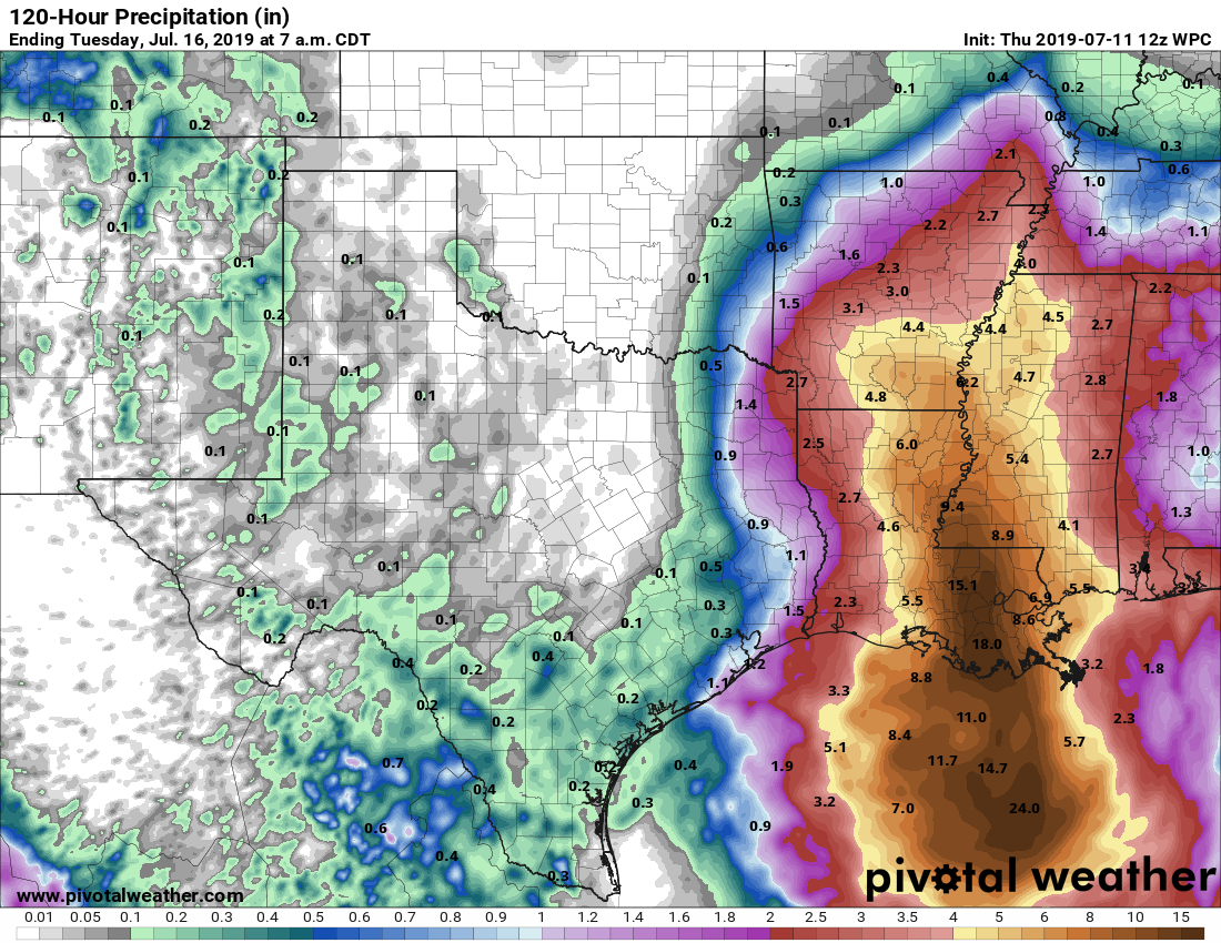
In regard to Barry, the greater Houston area should remain in the clear, with only perhaps 40 to 50 percent rain chances this weekend—higher near the coast, lesser inland—and probable accumulations of 1 inch or less. Galveston will be more susceptible to higher winds and thunderstorms this weekend than, say, Katy, but the entire Houston region is likely to lie on the far periphery of Barry’s action. Tides are unlikely to be a significant problem, although rip currents could be problematic.
We’ll have a full update in the morning.

I have plans to drive in to Lafayette Friday afternoon and to leave Sunday. Do you think that could still be possible? Or will I possibly end up being stuck there for an extra day or two?
Thank you for the update! I rely on you for the best weather forecasts and recommend your blog to everyone in Houston.
Saw a radar image posted just minutes ago on another weather page showing a HUGE area of convection just south of Upper Texas Coast, offshore…It made Barry look like a monster with two centers! The administrator of the weather page mentioned Barry taking on an odd shape..This had me freaking out and biting my nails..Then I came to your post, good info without the hype and fear mongering..Until I read your post, I began to think that the weather Gods were out to get me me for wasting some of my freshly filled tank of gas to drive to a pretty walking trail this am..
So what I am hearing is that Katy should go ahead and evacuate.
Can “evacuate Katy” commenters be banned? It is so “yesterday” and not even remotely funny any longer..
Where in Katy do you live?
A pretty strong thunderstorm is upon Bolivar Peninsula at this time—no rain quite yet at Crystal Beach.
Eric and Matt,
Thank you for the super job on this one with your typical “no-hype” reporting. And I sincerely hope Barry doesn’t badly hurt our friends in “Cajun Country.”
Thank you guys once again!
Sounds like a typical summer weekend for Houston. Maybe not so good for New Orleans though.
Latest spaghetti models seem to be shifting landfall more west…