We just wanted to offer up a quick update this morning to let you know that Invest 92L, or Potential Tropical Cyclone #2 has now been declared officially as Tropical Storm Barry in the Gulf.
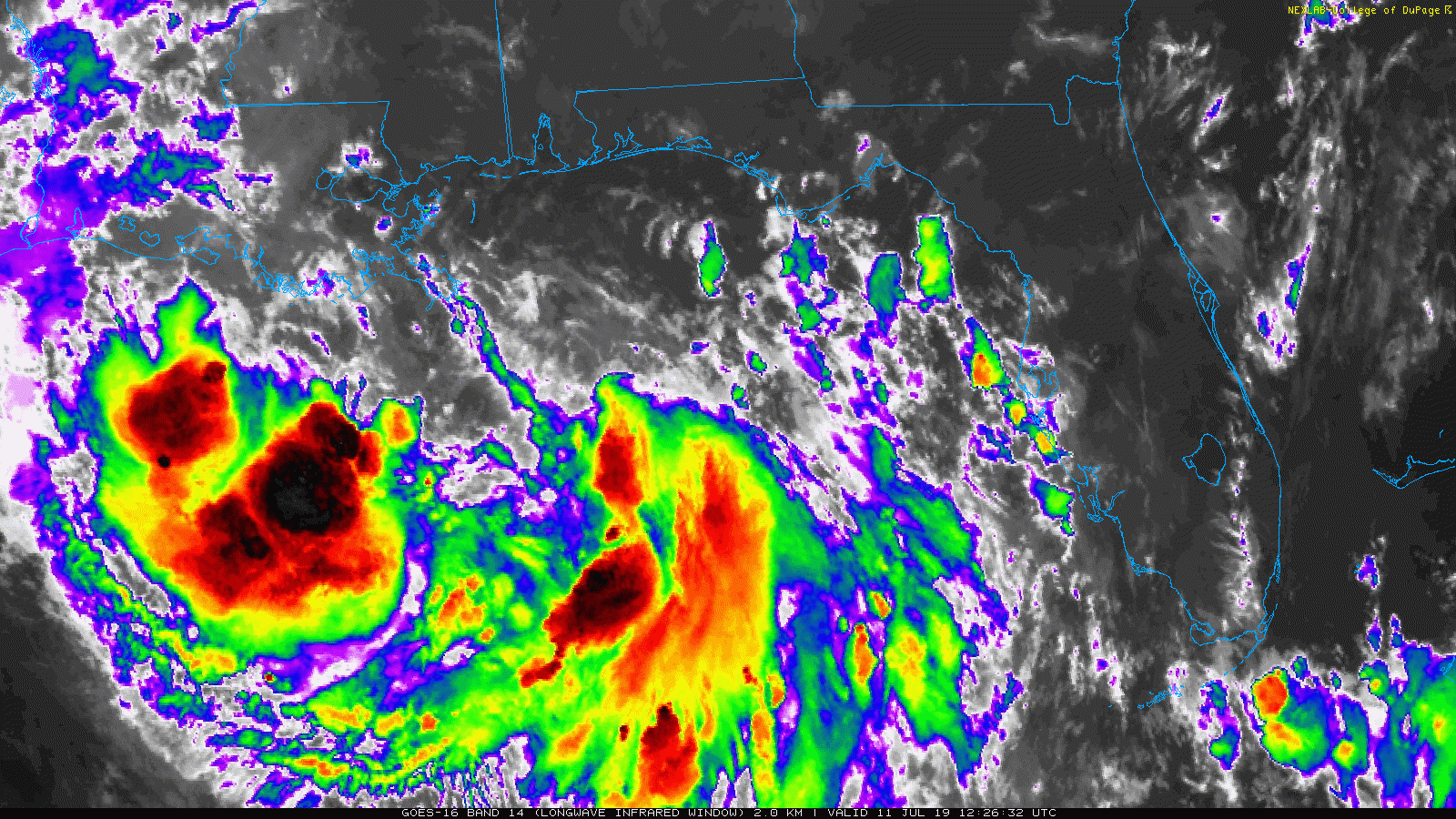
Maximum sustained winds are 40 mph as of the 10 AM CT National Hurricane Center advisory. The system is still struggling a bit to organize this morning, but now has a better defined center, enough so to be classified as a tropical entity. Most of the storms are displaced to the south and west of the center. Over the next 24 hours, the satellite presentation of Barry should improve, and slow strengthening should commence.
For us in Houston, the good news is that we remain outside the forecast cone, unlikely to see any significant impacts from what should become Tropical Storm Barry.
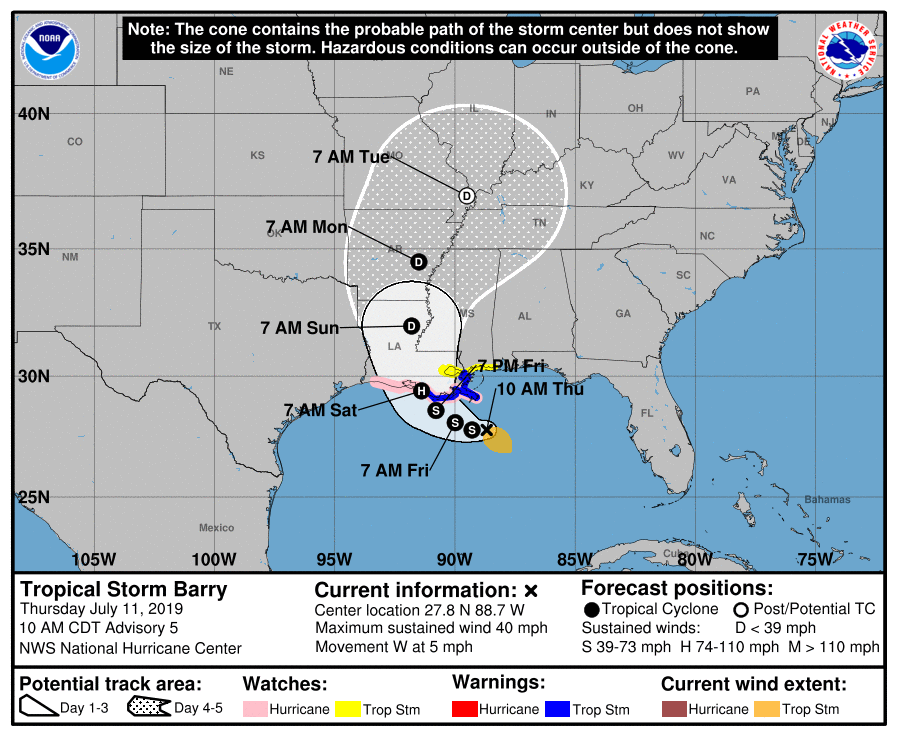
The National Hurricane Center is bringing Barry somewhere between Cameron & New Orleans on Saturday as a category 1 hurricane. Hurricane Watches remain hoisted from Cameron to the mouth of the Mississippi River. Tropical Storm Warnings are now up for the Louisiana coast east of Morgan City. For folks in Louisiana, this will be a tropical system, yes, but the main story will probably remain the rains that will fall, regardless if this remains a weak tropical storm or strengthens into moderate or strong tropical storm or hurricane. Those rains will all be capable of producing widespread flooding problems in the eastern half of the state and perhaps in Mississippi, should the storm shift any farther to the east.
Here in Houston, just keep tuned to the forecast, especially if you are traveling anywhere east of the region this weekend. Otherwise, expect some showers and storms to pop up this afternoon or evening. Some of the storms could be locally heavy.
Eric will have more for you later this afternoon.

We have a family weekend planned in Galveston this weekend. Is it going to be a total rain out if we keep our plans? I’m sorry for Louisiana, but glad Houston won’t get the brunt of it.
Thank you for all your work keeping us informed. You are most appreciated. No drama, just the facts as you know them. Love it!
We are leaving for Orlando and we’re going to leave at 3 am tonight. Do you think we will be ok on I-10?
New Orleans flooded bad yesterday, if you go you may want to use I-12 from Baton Rouge to Slidell
You’re brace, Scott. We postponed our Disney trip for one more week. We were scheduled to leave Friday as well. Wishing you the best on the roads and stay safe.
Yall had mentioned earlier in the week that if this went to our East and put Houston on the “Clean” side of the storm, that due to the direction of the wind this weekend would get extra toasty. It’s a little closer than anticipated in the beginning so do you think the extreme heat is still on?
Looks worse than it did yesterday and now they name it? i don’t think this gets anywhere close to hurricane status.
Agreed, and the less organized it is, the more rain we receive. The western side is exploding right now. I’m not saying we’re going to flooding rains, but 0-1 inch is a joke
We need the rain bad. not hurricane but rain . Everyone will be begging for ran August and sep
Thinking of all persons in Louisiana and travelers effected by Barry. Though Barry is a tropical storm, possibly a Cat 1 landfall, it doesn’t mean people shouldn’t take it seriously with regards to rainfall. Ike was a Cat 2, but moved through quickly because it was more “wind-driven”, while Harvey and TS Allison did more damage because they both sat on top of us with rainfall. Ugh.
NOAA also is talking about an Invest 93 off of Africa. Way too early to tell, but can you or Eric provide some information regarding that system in the future? (Cruise scheduled later this month.) Thanks!
Meredith: Invest 93L is not expected to develop much at all, and it should be ripped apart long before it gets to the Gulf or western Caribbean. No worries. And good points on the category not mattering as much. I wish more folks understood that.
Thank you. You and Eric are much appreciated!