The forecast today will be one of heat, followed by a somewhat uncertain outlook this weekend. Let’s walk through things, and then we will touch on Louisiana and Barry.
Today
The expectation right now is that today will be a mostly dry day in Houston. That said, I cannot entirely rule out some showers late this afternoon coming in off the Gulf along the coast or out of Louisiana for folks east of I-45. As long as it stays mostly dry though, it’s going to be awfully hot once again today. We should make a run for the upper-90s.
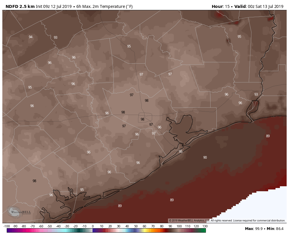
Heat advisory criteria may come close to being met in parts of the area, so if you’ll be outdoors, please take it easy. Also, keep that in mind if you’ll be on the beach today, as high temperatures in Galveston will likely make a run for the mid-90s with mostly offshore winds.
Tonight
Given the somewhat erratic nature of storms around Barry (see below), as it begins to approach Louisiana tonight, some of the outer fringe that has been fairly supportive of occasional clusters of storms may graze our area. So we will call it partly to mostly cloudy tonight, with a very slight chance of thunderstorms, virtually at anytime. We should know more about those prospects later this afternoon and will update you then.
Saturday
We could have a tale of two types of weather across the Houston area Saturday. For simplicity, we will use I-45 as our dividing line; the reality is it could be more to the east or west of that line, but it works for a generalization. West of I-45 could be partly sunny and hot. High temperatures may approach the mid- to upper-90s again. This would be most likely in places like Navasota, Katy, or Rosenberg. East of I-45 might be susceptible to more outer bands of Barry, which could yield occasional showers and thunderstorms and temperatures more erratic, ranging from the low-80s to mid-90s depending on who sees rain. This would be most likely for places like Galveston, Baytown, or Liberty.
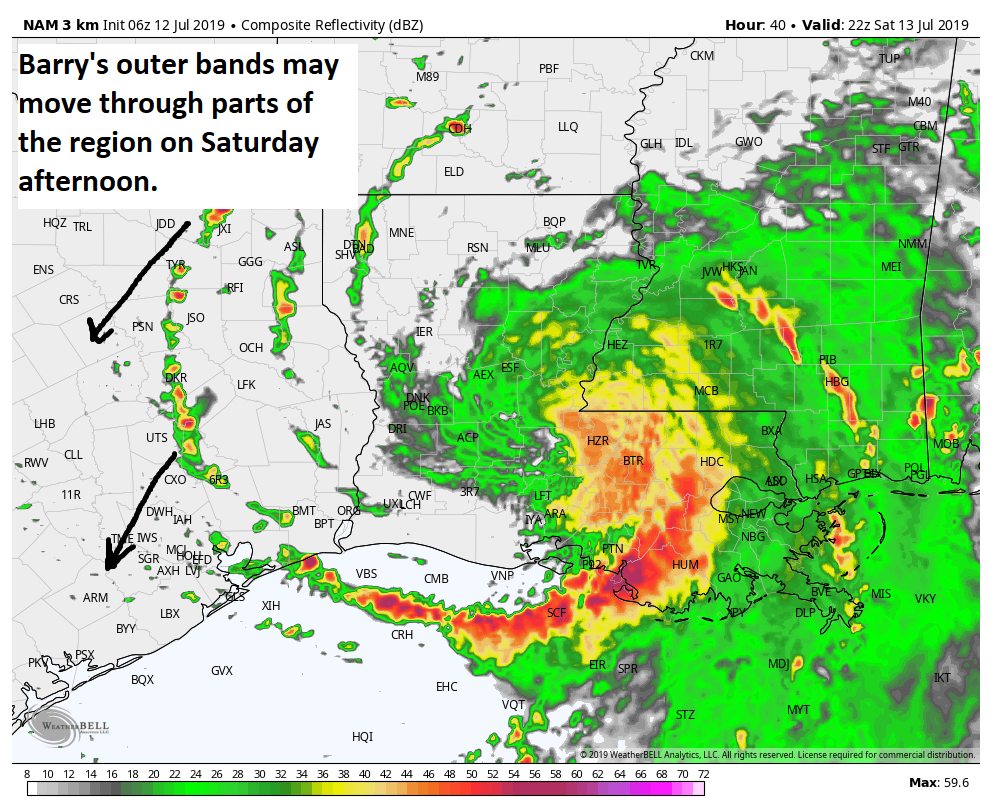
The general rule? The more to the east you go or closer to the coast you are, the more likely you will be to see showers or storms. Galveston will see a good chance for at least some storms, so stay lightning aware if you’ll be on the beach. Also keep in mind that any rain could be heavy at times.

Saturday night into Sunday
As Barry moves inland into northern Louisiana Saturday night through Sunday, things will begin to change a bit in our area. Modeling suggests that some type of convergence axis is going to set up either offshore or near the coast and Bay Area. It’s not yet a serious concern, but we will want to keep tabs on this.
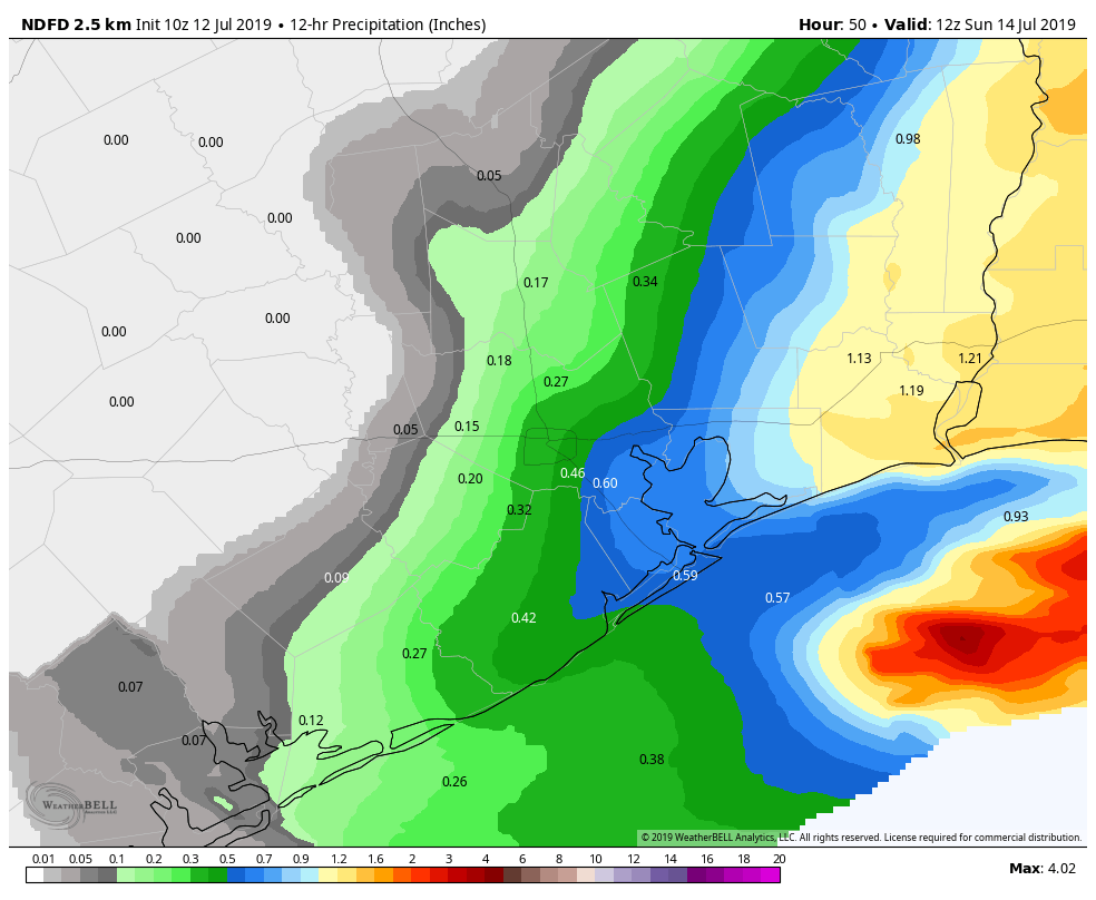
At best, we see an inch or less, with the majority staying offshore, closer to the convergence (or where rising air yielding clouds and rain is maximized). But if this “axis” sets up over Galveston or the Bay Area, you would be talking about slow moving or stationary band of moderate to heavy rainfall that could yield street flooding. Totals would be 2 to 4 inches or more for places like Galveston and Kemah and Texas City under that scenario. We will know a little bit more later today and hopefully much more Saturday morning. Stay plugged into the forecast.
Farther inland, it would be a mix of clouds and sun and hot on Sunday, with highs reaching for the mid-90s.
Monday and beyond
A few lingering showers could be left behind on Monday, so I won’t promise a dry day. But overall, the chance of rain begins to scale back considerably here and especially on Tuesday. We fall back into a limited moisture pattern, with only a handful of daytime thunderstorms on the sea breeze each afternoon. This would likely last from Tuesday straight into next weekend.
Latest on Tropical Storm Barry
Barry is slightly better organized this morning, but it will not win any cyclone beauty contests at all. The vast majority of the thunderstorms with Barry remain displaced well to the south of the center, which was located about 100 to 125 miles south of Morgan City, LA.
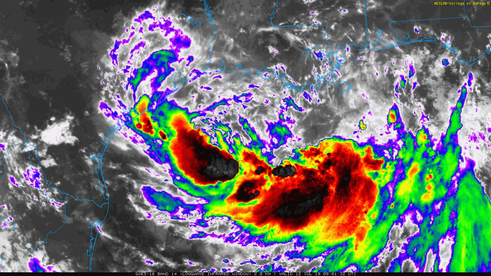
In terms of intensity, we are sitting with 50 mph maximum sustained winds, mostly in the eastern half of the storm’s circulation. If Barry can organize a bit more today, it will likely come ashore as a strong tropical storm or maybe a hurricane tonight and Saturday morning. That combination of gusty winds and broad onshore flow east of Barry’s center creates a sneaky storm surge risk in eastern Louisiana, Mississippi, and Alabama. This is a big reason why there were some concerns in New Orleans (although those concerns have eased up a bit).
In terms of track, even the outlier models you may have seen discussed a bit yesterday have shifted back to the east. Barry will make landfall somewhere in central Louisiana on Saturday.
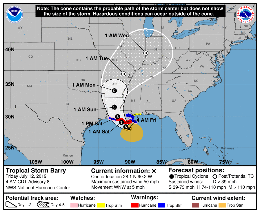
As far as rainfall goes, look for that to escalate a bit today in Louisiana and points east, with heavy rain likely in spots between Lake Charles and the Florida Panhandle. Heavy rains will maximize tonight and Saturday in those areas before lifting north and out.
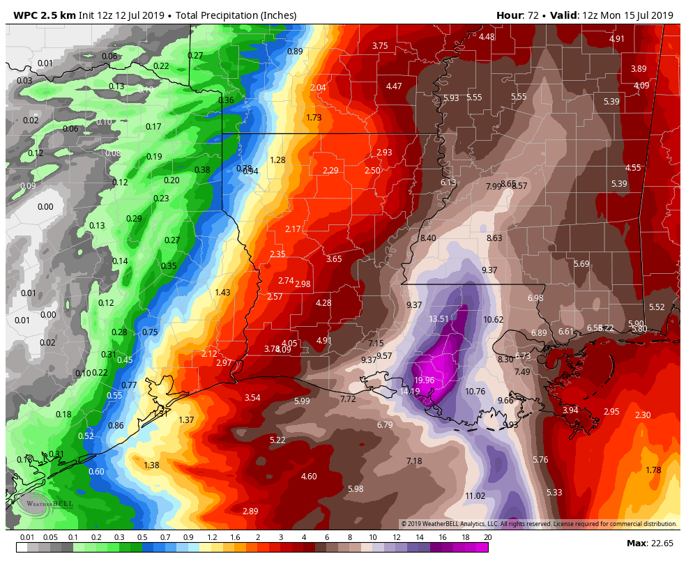
Total rainfall will peak in eastern Louisiana, averaging 8 to 16 inches, with pockets of 20 inches or more possible. Widespread issues with flooding are expected east of about Lafayette, LA.
Travel advice
We get so many questions about traveling. Here’s the most basic answer: For those traveling between Houston and points east, today may be doable, with most heavy rain south of there. But use caution if you must travel, as heavy rain and gusty winds could escalate later today.
Travel on Saturday east of about Lake Charles is not at all advised, as that should be the worst of the storm in those areas and east to Mississippi. Heavy rains may continue on Sunday, but weather conditions should improve along the route Sunday afternoon.
Unfortunately, there may be flooding issues on some routes Sunday, so if you absolutely have to travel then, you will need patience, a backup plan, and a way to get information on detours. Louisiana’s DOT has a good site and app. Heavier rains Sunday will fall in Mississippi and northern Louisiana. And watch for a band of heavier rain between Lake Charles and Galveston during Sunday.
Thanks guys for the frequent updates. Glad we’ll skip this one.
Matt and Eric, thank you for all your hard work!!
The NHC website still says the upper Texas coast should follow the progress of Barry.
Thanks guys, appreciate your good work.
so why is the current heavy rain and clouds to the south west of the center rather then the north east (the typical dirty side)?? Seems to me if this persists, we would have an unusual wet side to the west (over houston??)
The east side should begin to take over today. All that stuff over the Gulf should push southward and gradually weaken. The trouble has been shear and dry air, forcing the south side to be dominant to this point. Shear will continue, which could keep the western side a bit wetter than usual, and it’s why I am closely watching Saturday night/Sunday for areas southeast of Houston.
Very helpful, as always. Thank you.
“Barry is slightly better organized this morning, but it will not win any cyclone beauty contests at all.”
And this is why I read this blog, even on a sunny day when there are no weather events pending. (Although I did check in today to learn about Barry’s travel plans).
Best website for serious information, with levity and great writing all year long.
I guess I will have to cancel my flight from Hobby to Baton Rouge tomorrow. Maybe I can fly into Beaumont instead…..
Hobby to Beaumont? Not worth the airport hassle. If you can, rent a car.
That was a joke, but my senior year in college (just after the earth’s crust cooled) I did fly from Indianapolis to Beaumont via IAH for a job interview. Metro Airlines in a Shorts 330 following I-10 the whole way..
This storm is a dud. You wouldn’t be able to tell by the hysterical media. I’m so thankful for Eric and Matt.
It’s a dud for H-town, but it’s been making life pretty unpleasant for NOLA and its surrounds. Parts of Plaquemines Parish have been under mandatory evacuation since yesterday. This one missed us, but it won’t miss them.
I was going to say – if you think it is a dud, there is still time to drive to the central Louisiana coast to experience what a “dud” is.
The NHC posts an “Arrival Time for Tropical Storm Force Winds” that seems to include Houston, but no probability is posted. Is this something to be concerned with?
How quickly do you expect the storm to dissipate? I’m planning to drive from Houston towards Nashville, TN via Little Rock, AR on Monday.
Thanks so much guys for these awesome reports. I have a curiosity question though… earlier in the week everyone was expecting to be a fast mover once it turned north, but now folks are saying Barry is going to take his sweet time to dump (more) rain on Louisiana. What happened/changed to affect this? TIA!