Heading to the beach this weekend? I may not be your best friend after today’s post. After scattered showers and noisy storms on Thursday, we have some morning rain moving in today. Over the weekend, an upper level area of low pressure over the Gulf, sort of mimicking a disorganized tropical wave should help produce a good deal of rain and storms along the coast. This may keep beach weather at a bit of a premium going through the weekend, though there are still a couple question marks. The details…
Today
A batch of rain was sliding in from the east this morning, and we have also had some thunderstorms along the coast. Weather models hold this shield of light to moderate rain together this morning, fizzling toward midday.
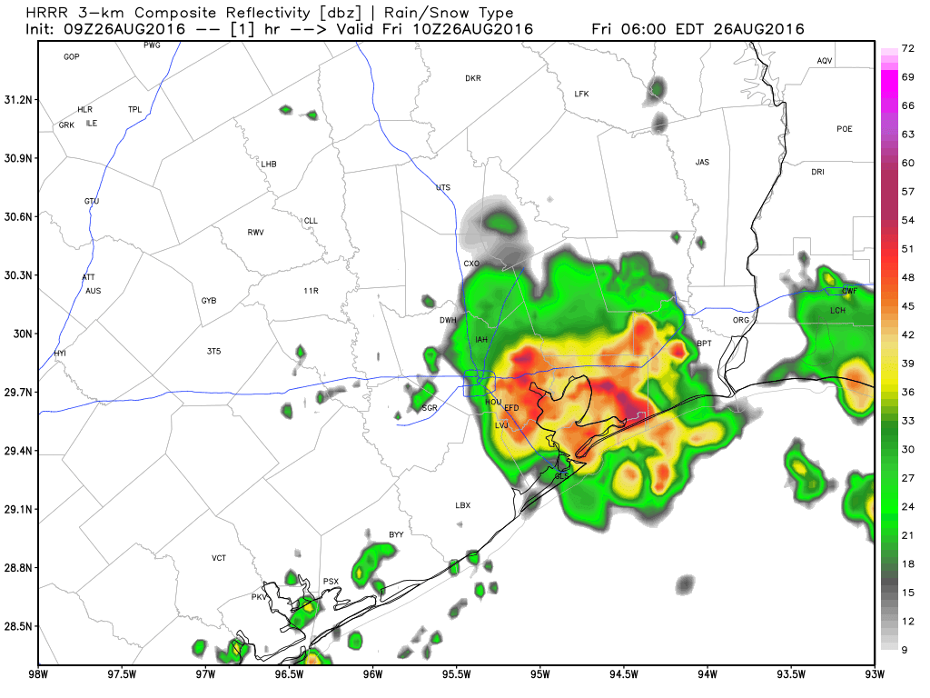
As we go into this afternoon, we should see additional hit and miss showers and storms pop up. Like yesterday, these storms will probably have a good deal of lightning and be capable of producing locally heavy rainfall. Not all will see them, but you’ll be well aware when you do. Temperatures should be held down a few degrees with additional clouds around, so expect upper 80s at best, mid 80s where clouds persist longer.
Weekend
The forecast this weekend isn’t ideal. We have an upper level low type feature in the Gulf that will begin to impact the region tonight and tomorrow. This means we should see organized showers and thunderstorms forming right up along the coastline tonight. This will likely continue into most of Saturday and Sunday. This will also be a tropical-type atmosphere, which means things might be ripe for funnel cloud development or waterspouts. So just keep alert at the beach.
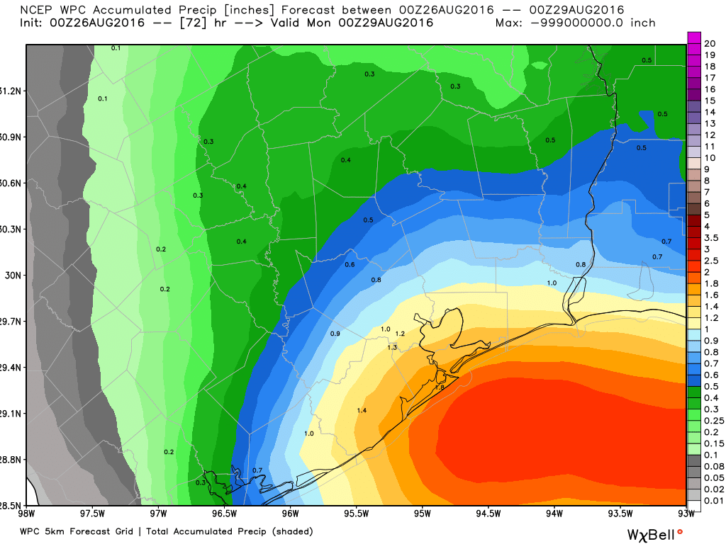
So how much rain? Well, as of now, the official forecast calls for 1-2″ of rain at the coast by Sunday evening, with lesser amounts as you work inland. A good boundary to use might be US-59: South and east of the highway, rain is likely to be more persistent and totals higher. As you go north and west, those totals will drop off and rain and storms should be more scattered and sporadic. The National Weather Service has said that they may post a Flash Flood Watch along the coastal counties over the weekend. We’ll continue to watch this for you through the weekend.
High temperatures in Houston this weekend should be in the mid to upper 80s both days, depending on cloud cover and how widespread the rain is. Expect cooler temperatures at the beach and around 90 to low 90s well inland. If I had to bet on afternoon plans, I might lean toward Saturday vs. Sunday, but it’s not terribly clear cut right now which day is likely to be drier. Neither day looks especially promising along the coast.
Next Week
Obviously, a major consideration for next week’s forecast will be Invest 99L (see below), but a few things stand out. Scattered storms are likely Monday as what’s left of the upper low/Gulf system spreads inland. Those storms will likely diminish Tuesday and Wednesday. By midweek, temperatures should rebound solidly into the low to mid 90s again. Rain chances look to be at a premium beyond Tuesday, but given the uncertainty surrounding 99L/Hermine, I think it’s best to view confidence in next week’s forecast as slightly below average right now. Speaking of 99L…
Invest 99L
Invest 99L is on life support this morning. It’s difficult to discern a center, there’s hardly any thunderstorm activity around it. It’s in bad, bad shape.
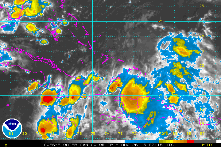
Weather models have bounced all over the place with it since yesterday, with the most aggressive, better skilled models reducing risk it develops, while tropical models continue to show a wide range of outcomes. The National Hurricane Center has lowered risk of it developing from 50% in 48 hours yesterday to 30% in 48 hours this morning.
This system is still worth watching over the next couple days as the wind shear over it relaxes, but the bottom line is this: The system is ragged and in poor shape. Even if it does emerge in the Gulf, it is in such poor shape, any organization will be slow to occur. Until this thing gets a center of circulation, tropical models (the infamous “spaghetti plots”) are going to be of little use, so I won’t even bother showing them. We certainly have nothing to worry about in Texas regarding this system right now, but we’ll continue to watch through the weekend to be safe. It is late August after all.
Posted at 6:30 AM by Matt
Thank you for the 99L update. This is a our first year in our first home on the gulf coast, so I’m a bit nervous. Y’all make it easier to plan ahead.