9 am CT Sunday: Good morning. The good news, right off the top, is that we’re basically in the same place with Tropical Storm Beta as we were 12 hours ago. Beta is truly struggling right now, dealing with things from dry air to wind shear, all of which make Beta a very lopsided storm. It’s still capable of causing problems, particularly with marine impacts and rainfall at a localized level, but we don’t see the forecast looking any worse today. And in some aspects, it looks better. Let’s swing through things.
Beta now
We will start by looking at the water vapor satellite loop over Texas and the Gulf this morning. The “drier” colors (dark red, brown, orange) that you see over Texas indicate voluminous amounts of dry air over the area. Go step outside this morning. It’s the driest air we’ve had this early in the day since June 11th in Houston. You can see it on satellite, but more importantly, you can feel it outside.
That will not help Beta at all. In fact, as Beta moves toward the coast, it’s arguably going to encounter even more of this dry air.
Additionally, Beta is sitting under about 15 to 20 knots of southwesterly wind shear. If you look closely at the map below, you’ll see Beta’s forecast track and the shear values in green, yellow, and red.
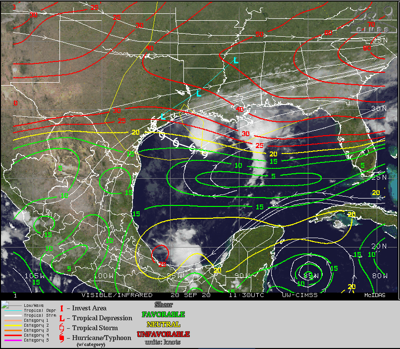
As Beta approaches the Texas coast, Beta’s wind shear situation will not get any more favorable, and in fact, it may get worse, with 20 to 30 knots of wind shear over Texas.
So, all this is to say that Beta is unlikely to get any stronger up to landfall. There is probably even some risk it may weaken a bit.
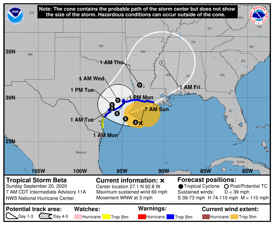
Beta currently has maximum sustained winds of 60 mph, but those are heavily displaced to the north and east of the center. That said, the wind field radius is 195 miles from the center. For a weak tropical storm, that’s a very large wind field. And this is why marine impacts are such a significant issue. More on that in a second.
Beta track & wind forecast
So we talked intensity above. Expect maximum sustained winds to hold at 60 mph or lower as it slides west toward the Texas coast today and tomorrow. Beta’s center will likely stall near or just inland from where it makes landfall on Monday night and Tuesday before resuming movement, this time off to the northeast on Tuesday night and Wednesday. Beta should be through with us by Wednesday night or Thursday.
Beta’s actual winds here in the Houston & Galveston areas will vary. North of I-10, winds will probably never exceed 30 to 35 mph and mostly in gusts. There should be few issues with wind there. South of I-10, winds could gust to 45 mph or so, and there’s at least a chance a brief period of sustained tropical storm force winds (39 mph or higher) is achieved in southernmost areas. Still, problems are expected to be minimal and power outages would probably be isolated in this situation. At the coast and along the bayfronts from Matagorda through Galveston and toward Cameron, LA, wind gusts of 35 to 50 mph will be possible at times as Beta moves in tomorrow. More sporadic power outages and perhaps some minor tree damage could occur in those areas. Overall, wind is not expected to be a serious issue for the vast majority of the region.
Beta marine impacts
The most significant problems from Beta will probably be caused by the marine impacts and the combination of heavy rain and high tides. Highway 87 and Blue Water Highway west of San Luis Pass experienced overwash overnight, and with tides expected to be about 1 to 1.5 feet higher tonight into Monday morning, the coastal flooding situation in those areas will only get worse. We will see tide levels at Galveston around 5 feet or a bit higher.
Coupled with 8 to 12 foot seas, we will see tides only drop slightly during low tide, so this will be a problem for several days with continued minor to moderate tidal flooding along the coast and bays. We should begin to see improvement in these areas by Tuesday afternoon or evening.
Beta rainfall forecast
We conclude with rain, the most challenging part of the forecast. Eric and I are going to maintain our flood scale posture of Stage 2 south of I-10 and Stage 1 north of I-10.
Overall our rainfall forecast has not changed. We are calling for a Stage 2 flood event for areas south of Interstate 10, and a Stage 1 event for areas north of the freeway. Be wary, not worried. pic.twitter.com/jXLmfZckPs
— Eric Berger (@SpaceCityWX) September 20, 2020
Weather models are generally poor at forecasting rain amounts with specificity and exact location, but the one trend that has been undeniable since yesterday has been to take heavier rain on the Texas coast and offshore and shift it more to Louisiana. The current rainfall expectations from NOAA still show high amounts on the coast.
These amounts are down pretty substantially from yesterday, however, now with 10 to 15 inches expected along the coast and 4 to 10 inches of rain in the Houston metro over the next five days. If these change further later today, I believe it will be to shift some of the higher totals more into Louisiana.
That said, this remains a very difficult and challenging rainfall forecast. For today, expect rain bands to begin to pivot into our area. Rain is already approaching Bolivar and Winnie and expect that to continue coming west today.
As we go into tonight, look for continued squally weather with periods of heavy rain and thunderstorms at times, especially south of I-10. We don’t feel that this will be a continuous rain event for the area, but it will come in bursts at times. This is generally good for bayous and creeks to be able to handle the rainfall without a ton of serious trouble. Where this could get a little more bothersome is if the core produces some heavy rain as it moves ashore tomorrow or Tuesday, especially south and west of Houston. That would be the most likely time we see rainfall rates that could cause some issues. But as of now we feel that for the most part the area can handle what is being thrown at it this week. Beyond Monday and Tuesday, there’s still some uncertainty, but pockets of rain are likely and in small areas (size-wise, think over like a couple communities or so) we could see heavier downpours and some more troublesome flash flooding. We’ll be watching all this closely and update you through today and tomorrow and beyond on any changes in potential or any ways we can get more specific about where heavier rain will fall.
In the meantime, we will have our next post no later the 2:30 pm CT Sunday afternoon.

I think you mean no later than Sunday afternoon 🙂
Toddler life is often a multi-day event. 🙂
Does the reporter sound like he is upset it wont gain strength or turn in to an killer storm. ?
Will Beta have any impact on Lake Conroe?
All things being equal TS Beta should make it wetter. But i’m no expert. Will have to wait for the guys to chime in.
I believe anything north of I-10 will be very minor in wind and rain department. But like they say prepare for the worst and hope for the best! Space city weather is the best! Thanks guys!
Thank’s Matt. You and Eric are a blessing to all of us here!
Indeed guys…lots of data, clearly presented…well done…thank you!
Thanks guys. Same Galveston reader who posted about moving on Monday morning a couple of days ago—postpone to next weekend or full steam ahead?
Not sure about where you are moving from or to, but FWIW, I left the island at 11:30 a.m. (Sunday) for drive back to Houston, and it was getting difficult to find roads not already under water in Galveston. Looked like it was only going to get worse.
Same story…if you can handle rain and aren’t moving to and from a flood-prone spot (from coastal flooding), you can probably do it, unpleasant as it may be. Tough to truly say.
Tuesday very early morning drive from Richmond, to Med Center and back… what are your thoughts?
Do you think there will be any issues flying into the airports this evening?
So even with all the dry air disturbing Beta, we may see 4-8 inches of rain in places? are we actually getting lucky?
If the totals are in the 4-6″ range then yes…we are getting lucky. However, if the front never made it down this far then the TS probably would not be heading this direction. If the TS did make it to us with a typical summertime precipitable water column then yes, it could be much much worse.
I shudder to think what Beta would do if we didn’t have all this wonderful dry air around right now.
Can we please get started on those Galveston Bay levees/parks to deal with future storm surge?
I am not a meteorologist but as of 1:30 pm the storm has a much better satellite presentation and looks to be moving more south than forecast. I would not be surprised to read in the next update that pressures have fallen and Hurricane watches are re-issued
So the dry air and cod front pushing the dry air are going to make Beta a nothing burger for Houston, it seems. 10″ of rain- which is unlikely, will barely get us to Stage 2 on your excellent Flood Scale.
(I do hope you and Eric have copyrighted that scale, by the way).
The satellite images show Beta getting shredded amazingly well.
Thanks for posting these excellent updates. Much better than TV or Chronicle.
Matt and Eric,
Many thanks for another no-hype analysis and forecast!
Rain in League City SSH since 8:00AM. So I guess we will not see a let-up until Wednesday, correct?
Will we be facing our usual challenges of being landlocked due to flooding on Hwy 96 as well as Hwy 646 and their feeder roads along I-45?
What does SSH mean? I take it that it’s not “super super hard” because I’m in league city and we’ve only had sprinkles.
South Shore Harbour?
South Shore Harbor…..got it, Rand McNally?
Matt – Sid Sperry from the SPIA Index here. We have a large contingent of power line workers in the DeRidder, LA, Lake Charles, LA, and Jennings, LA, area, making restoration efforts from Hurricane Laura. What are your sustained wind estimates from “Beta” in those areas for the period Monday thru Wednesday? They are staying in “tent cities” and there is a concern that if winds are going to be above 30 mph, the tents will need to be taken down and personnel evacuated. Your thoughts would be appreciated. Thank you! – Sid
Hey Sid, at this point, I don’t think winds will exceed 30 mph at LCH or inland in nearby areas.
I very much appreciate the work you two put into “space city weather.”. A more Houston focused source of weather has been long needed particularly during storm season and since I live in Clear Lake. Thank both of you for the clear writing and analysis. Mike Conway
The water is definitely up on the coast. I just went to Seabrook to move my boat and water was overtopping the boat dock – easily 1’ or more than usual high tide. The boat docks at Clear Lake Park on NASA 1 were also flooding – it would appear to be quite difficult to trailer a boat there now.
Matt and Eric, thanks for your updates.
Please clarify that the dry air will cause the storm to degrade or will inhibit strengthening. The wording in the post can be confusing.
Your analysis and posts are very useful in explaining these storms to my family.
Thanks.
Dry air would weaken the storm as long as it can be wrapped in, yes.