8pm CT Saturday: We’re still in wait-and-see mode with Tropical Storm Beta, which remains nearly stationary in the northwest Gulf of Mexico this evening. Here are our key takeaways this evening:
- Beta is fighting dry air, and moderate westerly shear. It still has the potential to strengthen, but the National Hurricane Center no longer expects Beta to become a hurricane before approaching the Texas coast, likely near Matagorda Bay, on Monday or Tuesday.
- Water levels along the Texas coast in places like Crystal Beach and the west end of Galveston Island are starting to rise in response to Beta, and the storm may inundate low-lying areas for a few days. Final preparations should be taken along the coast soon.
- Beta still poses a significant flooding risk to Texas and Louisiana that we need to take seriously. But we have lots of questions about this, and unfortunately no good answers right now. We’ll discuss this more below.
Flood chances
So this is a difficult one, and you’re going to have to bear with us while we suss out an accurate forecast. As a tropical storm, Beta definitely has the potential to bring a lot of rainfall to the Texas coast, and that is our primary concern. However, we do not think that is a slam dunk.
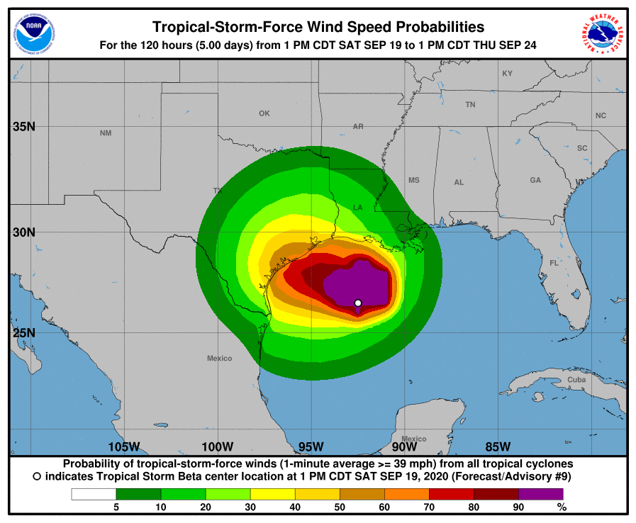
You may have seen the five-day rainfall forecast that the National Hurricane Center released with its 4pm CT package this afternoon (shown below). The totals are rather eye catching. This forecast seems to be a bet that because Houston will lie in the northeastern quadrant of Beta as it makes landfall and moves inland, that our region will see very heavy totals.

Yep, this shows a solid 15 to 20 inches along the coast, and a band of 10 to 15 inches across the Houston metro area. This is what you would expect from a typical tropical storm following Beta’s track.
However, there are several ways in which this forecast could go bust. One is that Beta moves far enough inland into Texas early next week that it gets cut off from a moisture supply. Two, Beta is going to be fighting dry air to its west, and this may starve the convection near the storm’s center, which would lessen rain totals along the Texas coast. Finally, we could see the heaviest remains far removed from the center. This is the scenario depicted in virtually all of the global model guidance, both their operational runs and ensemble outputs. Nearly all of this guidance suggests five-day rain totals of 2 to 8 inches across the greater Houston metro area, including Galveston. These models do not do a good job of picking up small-scale convective processes, but there is a strong signal here that is hard for us to ignore.
So what is our advice? We think the NOAA precipitation forecast offers a reasonable “worst case” scenario for rainfall, but we also think there is a reasonably high chance of a bust. We are not going to have the final answer on this for at least a day or two longer.
Coastal impacts
Water level rises along the upper Texas coast have begun today, and will worsen Sunday into Monday as Beta eventually moves closer to the state. Beta’s winds will drive large swells over the Northwest Gulf of Mexico by Sunday into Monday, which will bring waves on top of a storm surge of 2 to 4 feet along the Galveston and Bolivar beaches. This will flood low-lying areas, including Highway 87. Coastal flooding will also be possible in El Lago, Nassau Bay, Shoreacres, Seabrook and portions of Baytown.
The current estimate is that there is about a 50 percent chance of sustained tropical storm-force winds along Galveston Island and southern Brazoria County. However, there are real questions about whether Beta is going to be able to battle moderate shear and dry air to intensify further than its 60-mph sustained winds as it moves toward Matagorda Bay, further down the coast. Along this track, we do not anticipate widespread power outages due to downed lines in Galveston or Houston.
So that’s what we’ve got tonight. Matt will have our update no later than 9am CT Sunday.

Thanks for the on-time and detailed update, always appreciated.
I was just looking at the updated (~8pm) rainfall totals posted at NHC which still show 6-10 inches here in NW Houston, compared with the 120h totals of just over 1.5″ in the 18z GFS model.
I was scratching my head, trying to understand the disparity – thanks for illustrating the factors that can account for that kind of difference!
What happens, happens. But here’s hoping the scenario that has it moving rapidly inland is the one that occurs. Cut off from the supply that could make for huge rainfall amounts, this is the best plausible ending. Fingers crossed. Here’s hoping y’alls report in a couple of days is more certain and promises that scenario. Thanks Eric, we’ll keep checking with you.
Favorite phrase: “…while we Suss out…”
Least favorite: “ the NOAA precipitation forecast offers a reasonable “worst case” scenario for rainfall…”
Much appreciation for the update. I’ll be reading with full attention/anticipation.
I live along Braes Bayou in Meyerland. Should I be worried?
Yep. But within reason…
Mandy,
All of us who live along Brays Bayou live in a high potential flood zone.
That said, this Beta storm is looking less and less likely to do more than scare us.
The huge amount of dry air being entrained into the storm will probably prevent it from being another Harvey or tax day or Allison type flood.
But this is weather, and this is Houston: a volatile combination.
What does this look like for Beaumont area. We flooded in Harvey.
Thank you Eric, your no hype honest intelligent forecast is appreciated. Thanks for taking time from your family & daily life to share your expertise.
I cannot express how much I appreciate no-hype information…I’m a data guy, give me facts and what they mean, good or bad, knowing that in a dynamic situation they might/will change…you guys are providing a much needed service in this most awkward time on Planet Earth…thank you!
,
Haven’t heard that expression for a while… ‘suss out’ !! 🇬🇧
Thank you for keeping us informed 🌨
It’s interesting that the HRRR model shows the storm making a beeline right into the west side of Houston. And fairly quickly too.
My question:
How do the models handle storms as they approach landfall? Is one typically better then the other? Seems lately all the models have been great on direction but terrible on intensity. My imagination?
Random question (that has nothing to do with beta, I hope…) would they retire a Greek letter name? Just skip it in the future or replace it with another b word?
Which letter was skipped?
I think Sean means that if it was a catastrophic storm that started with a Greek letter, would they retire the letter itself, replace it with another word that starts with that letter, or do nothing?
I believe they would specifically retire “Beta 2020” and there would still be the possibility for future “Beta” storms.
Hype free is fine, but you can lose the PTSD over Rita already. Your posts need revision with each model run.
They update multiple times a day when there’s a system of concern in the Gulf.
And you apparently have no idea how PTSD works.
Something to bear in mind is that in comparison with the models NHC have been almost unerringly accurate this year. I wouldn’t discount their forecast too readily..
I find it funny how many mentioned the word “suss”ing. It’s a good word because it requires contemplative thought based on facts and data rather than willy nilly speculation. That’s why ya’ll are my favorite weather guys. So…we are in a holding pattern while sussing the data. We’ll tune in tomorrow morning to see what has been discovered…. Thank you.
We cannot thank you enough for your brilliant, no-nonsense analysis and insights. You are truly an invaluable asset to the people of the greater Houston area. Thank you so much!
Eric,
Great report as usual.
Any insights on how dry air masses behave? It seems that the behavior of that lovely dry air is the key to how beta will transpire. We obviously and correctly pay close attention to the humid air masses. They are what cause what we call “weather” in a way.
If humid air masses are like the fuel for weather, then dry air looks like the fire extinguisher.
Unless you’re somewhere with low humidity ie California, then the dry winds are the proverbial “match strike”
Dry air is a relative term, lol
Should Katy Evacuate???
Immediately, post haste, if not sooner.
You guys do a great job presenting/explaining, without the media hyperbole.
You guys are the best.