2:30 pm CT Sunday: Our post this morning was sour on Beta. Maybe we trash talked it too much. I don’t know. What I do know is that it looks much healthier than I expected 5 to 6 hours ago, and it’s conceivable that Beta is at least making an attempt to form into a hurricane — temporarily. We still feel that despite the changes in the near-term, the overall forecast ideas we presented earlier today still hold. The area most likely to perhaps see some forecast changes because of what Beta is doing right now would be the Matagorda to Freeport area, which could see some slightly stronger winds or slightly higher surge if Beta does indeed strengthen a bit further.
Beta intensifying?
According to the 1 PM National Hurricane Center advisory, Beta still had 60 mph maximum sustained winds, mainly north and east of the center. The reconnaissance aircraft that sampled Beta this morning found ample support for these winds. But over the last 3 hours or so, Beta has clearly begun a burst of intensification.
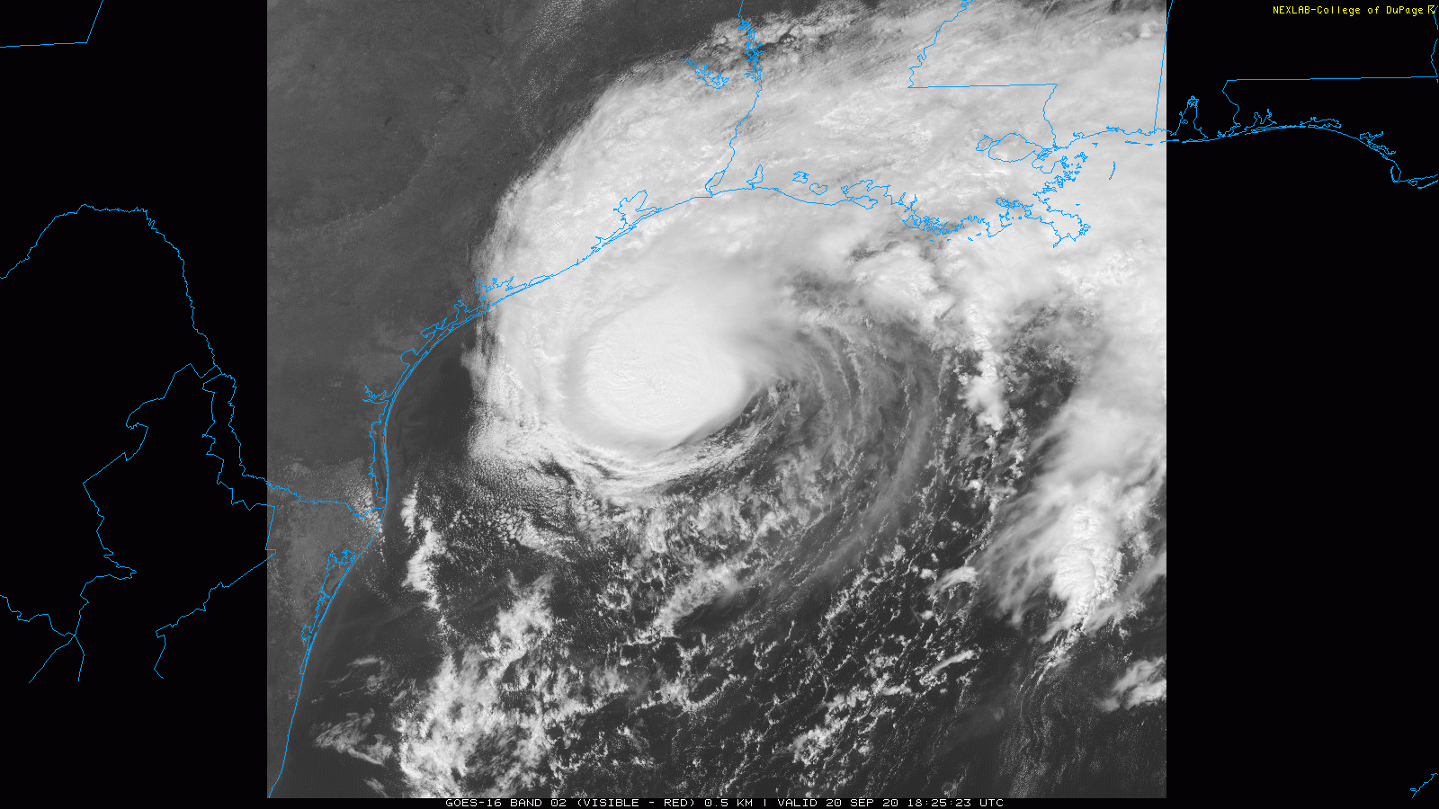
Beta actually looks like a reasonably competent tropical cyclone now. In fact, if you look at radar, you can see a nascent eye-like feature developing. That doesn’t make it a hurricane, but it does mean that it has organized itself, perhaps feeling a brief pause in shear or dry air and the very warm Gulf water it sits over.
My guess is that Beta is a strong tropical storm at the moment. But as it approaches the coast, a wall of dry air awaits its arrival. It will be tough to keep that dry air out of the circulation. And the expectation will remain that Beta begins to weaken as it approaches land. That has been the hypothesis since day one, and that still holds true today. The only way that changes is if Beta can insulate its inner core enough from the drier air that is waiting. That’s always a tough call, so we want to continue watching it, but the expectation is that dry air will begin to take a toll on this core later today or sometime tonight.
Sunday rain
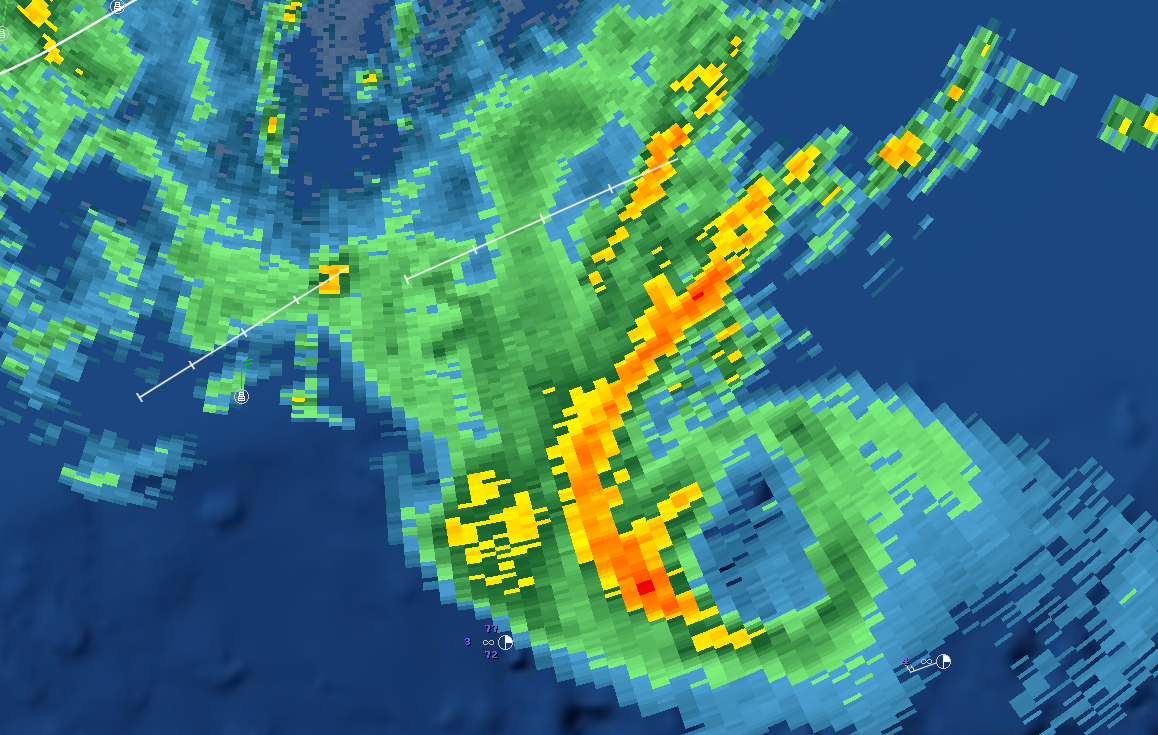
For much of the Houston area, rain has been falling this afternoon, heavy at times. Totals have generally been one inch or less.
You can see the outer bands of Beta with some heavier rain indicated in yellow on the loop above. This initial wave of rain should taper off a bit later today, but we will likely continue to see gusty showers or even some thunderstorms at times into tonight.
Total rainfall forecast
NOAA has updated their rainfall forecast for the event total, and they have indeed brought values down a little bit further. It looks like they shaved off about 1 inch in Houston to as much as 3 or 4 inches Galveston. Granted, some rain has already fallen, but not as much as has been removed. So, some good news there.
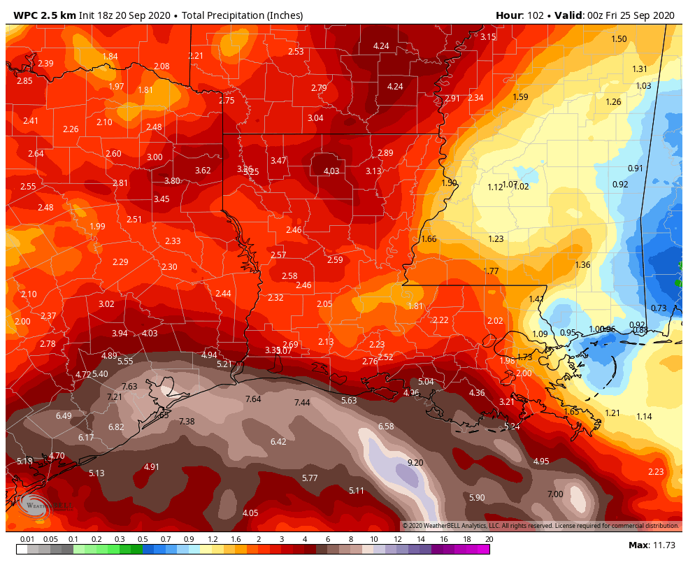
As we’ve been stating, we don’t want folks to just assume this is a non-event; you should remain vigilant in the days ahead. There will be periods of heavy rainfall. But as far as major, widespread flooding, we do not see that scenario as being likely at this time. Still, it may be good to take sensible precautions if you live in a typically flood prone area, particularly with respect to street flooding, just to be safe. In tonight’s update, we’ll offer some thoughts on how Monday’s rainfall may play out.
Marine impacts
We covered this in depth earlier this morning as well. At Galveston, at the railroad bridge near Tiki Island, we saw about 4 foot water levels this morning. Expect that to be about a foot or so higher tonight and end up in the 5 to 6 foot range.
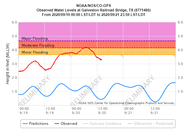
This will cause widespread moderate coastal flooding along the entire coast and bayfronts as well. Expect that to continue much of tonight and Monday morning, with only a slight drop in tides Monday afternoon, followed by a similar peak in tide levels tomorrow night before things subside. This will be aggravated by 8 to 12 foot seas and higher waves offshore.
That’s all for now. Our next update will be posted no later than 9 pm CT on Sunday evening.

Thank y’all for working through the weekend to keep us informed.
Has the Rockport area escaped wind and rain?
Thank you again for the up dates.
Rockport probably won’t have significant impacts, but could see some gusty winds and heavy rain too. Coastal flooding issues will continue and may get a bit worse late tonight. But probably not awful.
We are susceptible to car flooding and move our cars (lost them on Memorial Day and moved them for Tax Day event – which saved them). Therefore curious about if you have any sense when the most intense rains might come. Your forecast seems to lean to Monday, but want to make sure I don’t wakeup tomorrow to regret not moving them tonight. I recognize that those were Stage 4 Events, and you are predicting Stage 2 – just trying to be prepared.
The lean is Monday into Tuesday right now.
Thanks for the reply and many, many thanks for this great public service.
How much inches of rain??
A question and a comment: As the rain falls and the ground starts to saturate, does that cause a cycle that causes the air to gain moisture which can then be pulled into the storm?
At this point my weather station is reporting 1.60″ with a rate of .31″ / hr currently.
It can happen, yes. But the environment around the storm still has impacts enough that can weaken it because the dry air gets wrapped in from the north and west.
how much rain and flooding is there going to be in houston?
Katherine it is in the post above.
Beta Testing. I like it. Did you get that one from your I.T. guy?
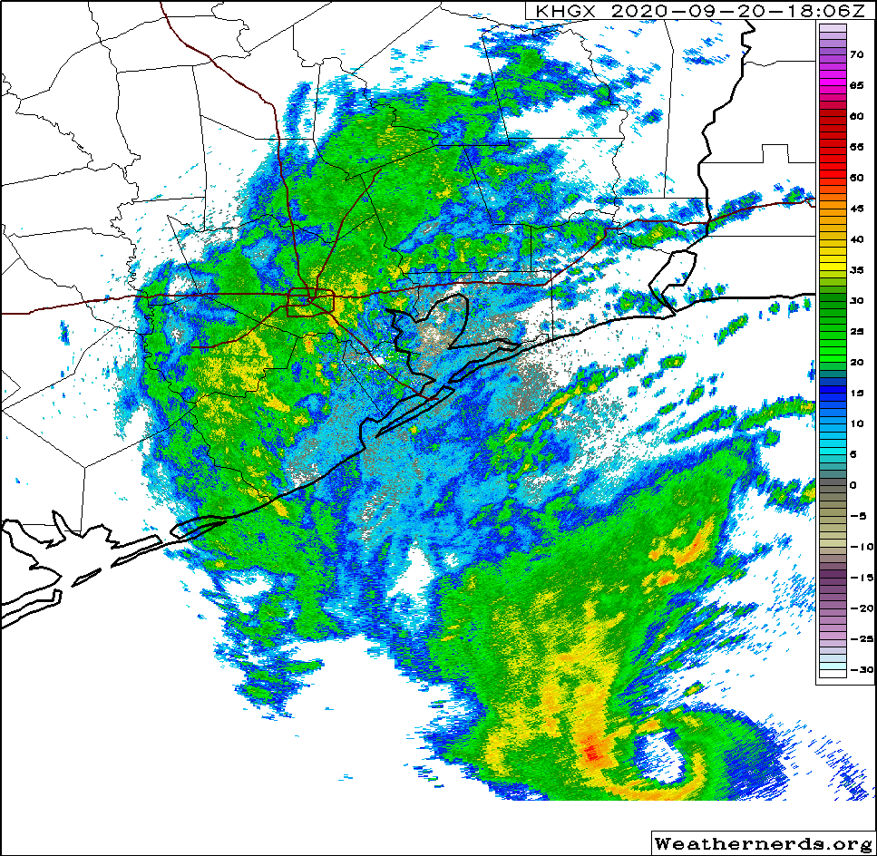
In the weathernerds image, there is a scale from -30 to 70, with a rainbow of colors. What does the scale indicate? Unlike the other images which had an accompanying caption, this image’s caption said nothing about what that scale was, what it measured, and why the scale went from-30 to 70.
What does 15″ of rain mean for the Clear Lake area? Sounds like heavy flooding? Thanks for your reporting.
It is “DBZs” or what the radar is picking up in terms of intensity. The higher the value, generally the heavier the rainfall.
Thanks for all of your work; it is appreciated.
I’ll beta lot of thought went into this post’s title.
As always, really appreciate the no-hype reporting laced with humor. Thanks again for walking us through another potential storm and working around the clock.
We paid a king’s ransom to have our home raised about five years ago. I can’t tell you how good it feels not having to be concerned with flooding. I really don’t expect much in the way of a major flood event for far east Harris County but anything is possible. The forecast SCW provided gives me hope that most people will come through this without their homes flooding but there are always exceptions. Thank you for the indepth reporting and frequent updates.
New discussion is out. Were they saying that the “eye” feature people were pointing out was actually dry air trapped in the system? I am glad they threw cold water on the intensification talk, because people were getting carried away with it.
No. It was really an eye trying to form. However, it is at the mid levels of the atmosphere. At the lower levels of the atmosphere the center, can’t really call it an eye, was shifted westward in relation to the mid-level eye feature. What this means is the rising column of air is tilted, which usually means the storm is having trouble spinning up. If you look at a water vapor satellite image you can clearly see the difference as well as the dry air, which you correctly mentioned, is getting pulled into the mid-level eye, causing it to deteriorate.
I would like to see more future tracking information in your next update.
In the text above Matt states the forecast track in the morning update is still valid. Right now it looks like the storm may track right across the 1-10 corridor. Until the storm makes its eastward turn the exact track is still fairly uncertain.
Galveston having no real rain!! We desperately need it! Hopefully we get at least an inch out of all this Beta stuff!! Last real rain here was in the Spring! Nothing from Laura after evacuating! Miserable!
Thank you Eric and Matt for the always excellent coverage. One request – when you link to the GIFs or animations, could you also add a tag to include a link to the source? Meaning, if I click on the GIF or image, it takes me to, say, the weathernerds site?
I’m a very, very arm-chair armature meteorologist, but I am very interested in learning how to interpret the source data itself.
Keep up the very, very excellent work you two! And Lee, for keeping the site online!
Amateur*. But I suppose “armature” works well, if the context is me being an arm-chair pseudo weather guy for my friends lol