2pm CT Saturday: Tropical Storm Beta made its expected turn west earlier today and is now crawling toward the Texas coast at 2 mph, according to the National Hurricane Center. Its maximum sustained winds are 60 mph. Our overall forecast for the Houston metro area has not changed at this time: We still anticipate Stage 2 flood conditions south of Interstate 10, and Stage 1 for areas north of Interstate 10. Bottom line: We have not seen anything today that makes us any more concerned.
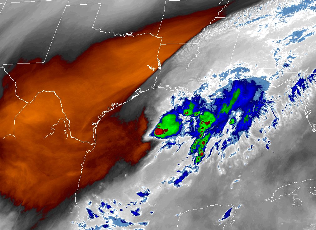
I want to start with a satellite image of the Gulf of Mexico this afternoon that illustrates water vapor—a good proxy for convection. When you look at this image there are a couple of important things to notice. One, the precipitation associated with Beta is strongest near its core and well to its east. Second, the reddish hues across Texas indicate dry air. Some of this dry air is wrapping into the circulation of Beta, which is helping to hamper its intensification. Finally, it’s clear that until Beta moves further west the bulk of its precipitation is going to fall over the Gulf, or southern Louisiana.
In this afternoon post I want to discuss the timing of what to expect after today, and when. The usual caveats apply, this is a dynamic weather system, so forecasts will change. But this is our best guess as of 1:30pm Saturday afternoon.
Sunday
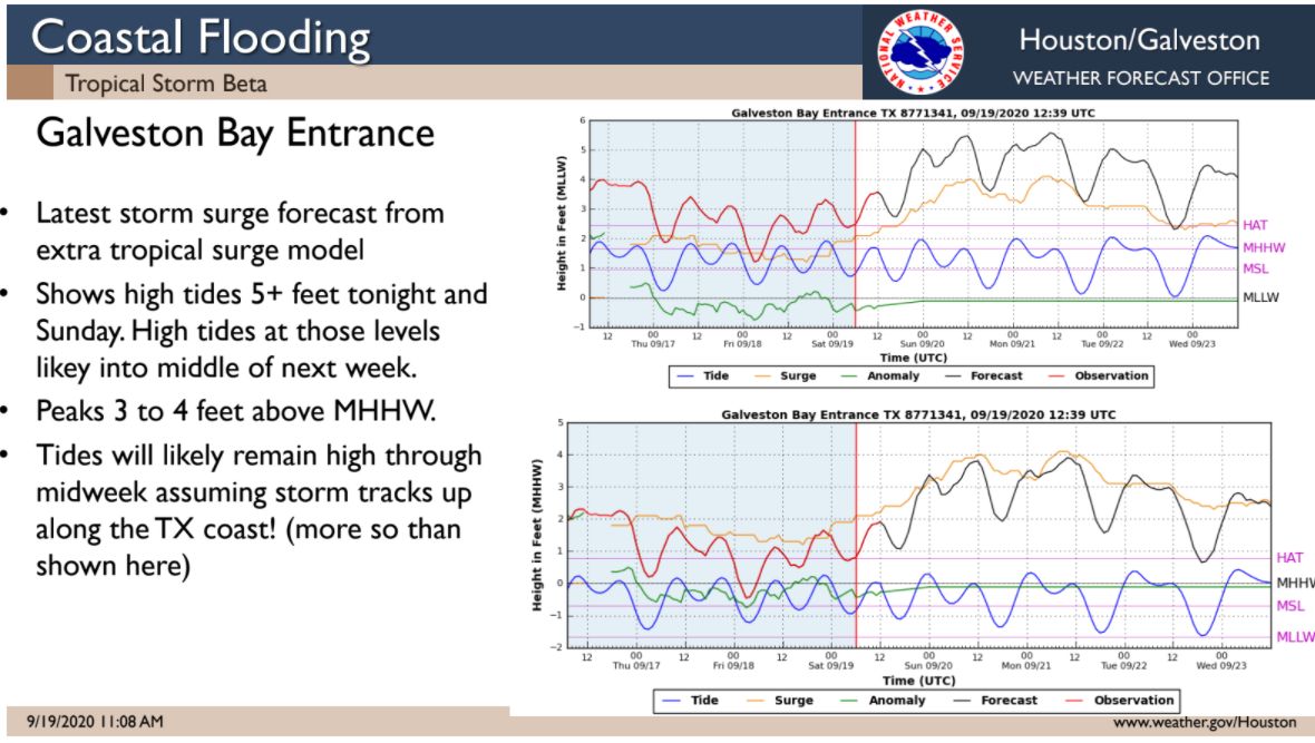
Beginning fairly early on Sunday we could see some outer rain bands from Beta moving into the Texas coast. Most likely these will be light to moderate, at least during the daytime hours. Coastal areas may see upwards of 1 to 2 inches of rain, but inland areas will likely see less. All in all, this should not be too disruptive. Coastal areas may see tides 3 to 4 feet above high tide levels, particularly on Sunday evening, and Monday morning. Tropical Storm force winds may arrive along the coast, from Matagorda Bay to Galveston by Sunday evening or during the overnight hours.
Monday
Most of the best available model guidance suggests we will see similar conditions on Monday as the storm’s center nears the Texas coastline, probably near Matagorda Bay. I should note that overall confidence in this track remains somewhat low, and that a northward jog in the track would bring more serious winds and surge into Galveston Bay. However, we don’t expect that right now. Beta will likely will be a high-end tropical storm or a low-end Category 1 hurricane at this time. Winds will probably increase across the Houston area, although I’m not sure they will reach Tropical Storm-force.
Tuesday and Wednesday
These are the days when we can probably expect the heaviest rainfall, although amounts are still to be determined. This is the period when we expect Beta (or the remains of Beta) to begin lifting to the north and then northeast, perhaps bringing its circulation near the Houston metro area. By Thursday we should see improving conditions across Texas.
So really, how much rain?
If you remember the satellite image at the top of this post, almost all of the convection and strong storms lay to the east of the storm’s center. We think that the most likely scenario is that this pattern continues during the coming week, and we end up with a situation where most of the Texas coast north of Corpus Christi sees 4 to 12 inches of rain over the next week, with lesser amounts inland. This is very general, ballpark value. The key thing to remember is that this scenario would not lead to widespread, catastrophic flooding.
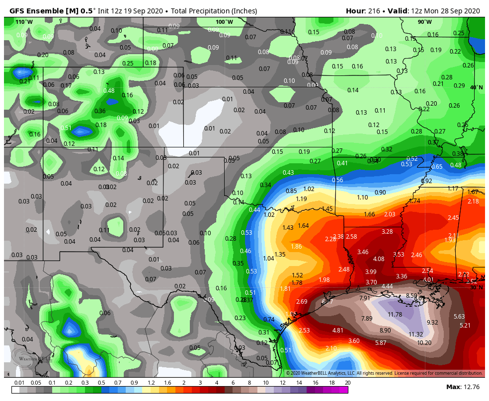
However, we cannot discount the possibility of Beta really getting its act together over the next day or two, and becoming a prodigious rainmaker over Texas. In this reasonable worst-case scenario, areas from Matagorda Bay to Galveston to Beaumont are at risk for 20 inches or more of rain, with 10-plus inches for parts of Houston. That is the high-end risk. But again we do not favor that scenario right now; and if our view changes we will let you know post-haste with a hasty post.
Our next update will come no later than 8pm CT this evening.

Incredible close to this article. Nice, and well played.
Eric and Matt. I have elderly parents down in Victoria and work all day today. What do you expect there tomorrow? If I need to go help them prepare should I go tonight or should tomorrow be ok? Thanks!
Guessing winds of 30-45 mph for Houston?
In future posts can you comment more on wind for us, esp Pearland? It’s the wind that makes me want to run away…
Grateful as always guys. Thank you!
We have a place in Sargent. What can we expect?
Hello Eric & Matt! I live in Texas City, TX and would like to know if were under the same risks of flooding like Galveston? Thanks.
Fellow TC resident here, and having lived here through Harvey, Imelda, and various other heavy-rain storms in the past few years, if you live in the majority of Texas City, you’ll be fine. With the dike, the seawall, the lagoon, the big hill between the lagoon and the bay, Moses lake, and the four pump stations, Texas City doesn’t flood. If you live in the fringes, that might be another story, though. Some of the neighborhoods by the Mall of the Mainland and on the way to Dickinson took on water during Harvey.
Thank you so much for your response Shark. We have lived in TX City for about 18 months and previously moved from League City. We were spared by Harvey due to being on higher ground on Calder Dr. I know the home I live in now hasn’t ever flooded and hopefully it wont this time around.
I just love you guys!
In historic flooding please don’t forget the May 2015 flooding in Clear Lake area that took a Man’s life.
So stage 2 to confirm should we be wary and can we expect street flooding in clear lake area ?
Many drainage issues in that area. ~ two time flood victim (I live far from actual water but there is a drainage issue in my subdivision that the city of Houston ignores.
Thank you both for all of your input.
Just want to say Thankthehellouttayouse for trashing your weekend just to keep us informed. Y’all are wonderful
I wondered why Travis was getting so worked up over this storm last night at 10 PM given I had just looked at the then latest GFS run. After reading this, I’m still wondering.
Probably won’t even get a day off work – – oh, wait, they’ve had us on work from home for six months now. Never mind.
Really appreciate the combined water level, tide, and surge chart with timing for us along the coast.
Very thorough anaysis of what we can expect. Helps everybody decide on the best preventative measures to take for their situation. Thank you.
I keep thinking that Beta is gonna be in a hurry to make it by September 24. Have to preserve the statistics!
What kind of wind speeds do you expect in Houston?
I’m more worried about winds and power outages!
“Our next update will come no later than 8pm CT this evening.” It’s 8:03p!!! 🙂
Slow upload speed.