6:55 am CT Monday: Good morning. The overall situation with Tropical Storm Beta remains the same. Coastal regions are seeing very high water levels due to tides, surge, and prolonged easterly winds from Beta. We’re expecting intermittently heavy rain over the next few days in the greater Houston region, but we do not anticipate widespread flooding issues. Before diving deeper into the forecast I wanted to allay any lingering fears about a slow-moving tropical cyclone making landfall south of Houston.
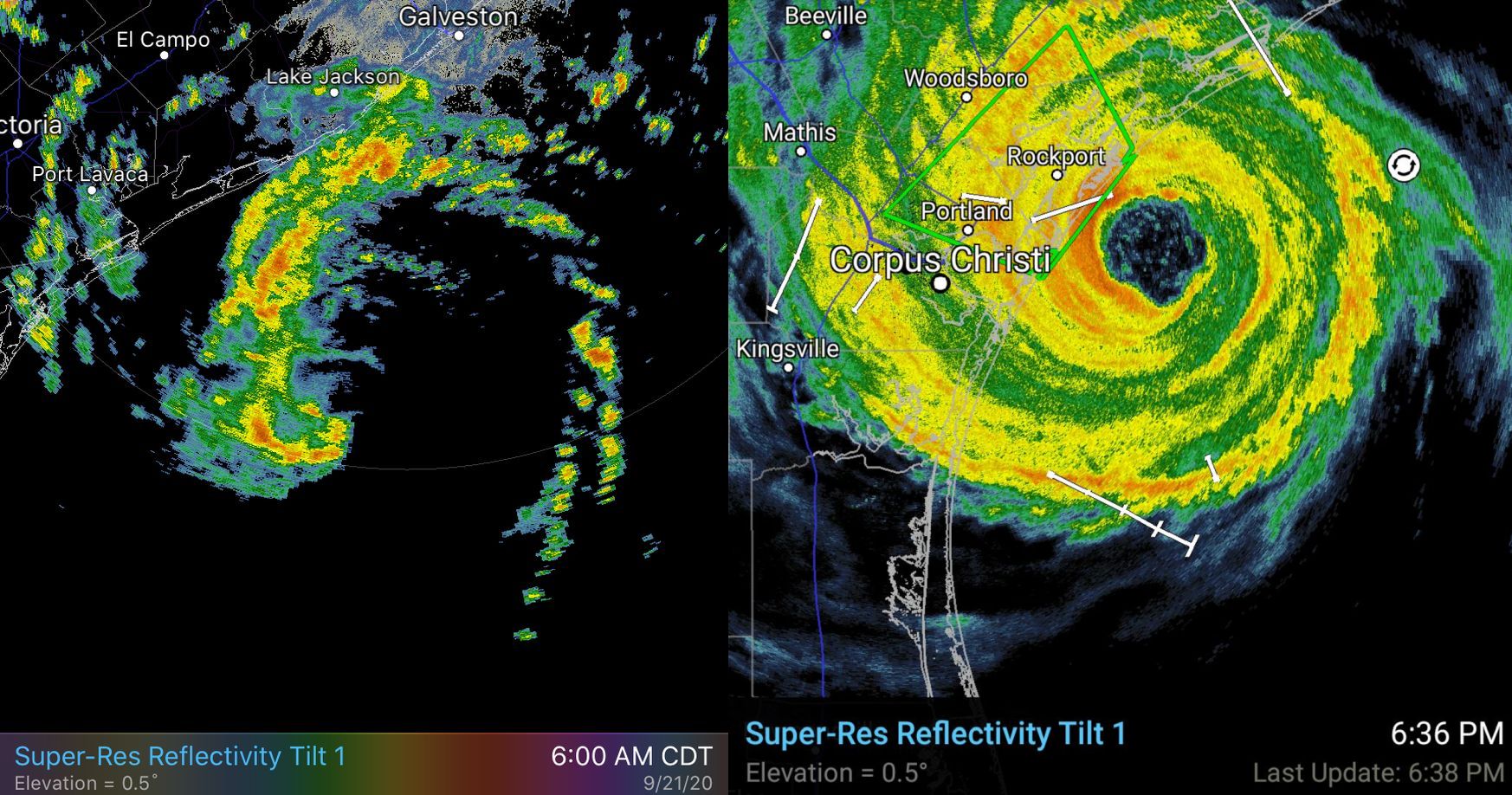
We’ve been saying for days this will not be another “Harvey” for the area due to a variety of factors, including dry air over the state. We realize many of our readers have PTSD after that nightmare storm, and that’s why we created our flood scale messaging. As we have done since Friday, we’re still forecasting a Stage 2 event for the coast, and Stage 1 for inland areas. Rest assured, if another Harvey like-system approaches Texas, we will tell you. We’ll be shouting about a Stage 5 flood from the rooftops. This is not that, however. A radar image of Beta this morning (left) and Hurricane Harvey in 2017 shortly before landfall tells the entire story.
Beta summary
The storm has weakened over night, and now has sustained winds of 50 mph. It is moving slowly to the west, and will likely make landfall along, or south of Matagorda Bay later today or early Tuesday. The storm is continuing to battle moderate wind shear and the entrainment of dry air into its circulation. These factors are unlikely to change much as the storm nears the coast, and the National Hurricane Center anticipates it will remain at its current intensity until landfall. After this time it should slowly weaken as it tracks inland, or along the coast, before exiting to the northeast on Wednesday or Thursday.
Immediate threat
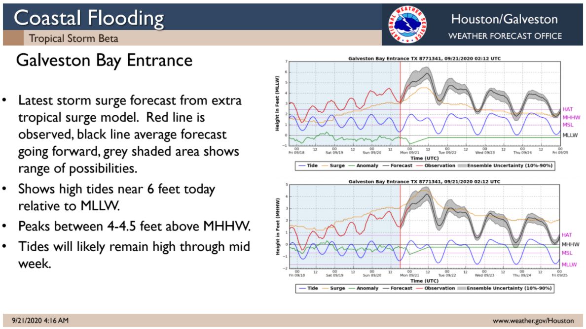
The most pressing problem at the moment is tidal surges along the upper Texas coast and along nearby waterways. Tides are running 4 feet or more above normal along the coast and locations such as Clear Lake, and affecting nearby roadways. Tides will remain high today and tonight before perhaps receding a bit on Tuesday, and likely considerably more on Wednesday. Take care on low-lying roads.
Rainfall potential
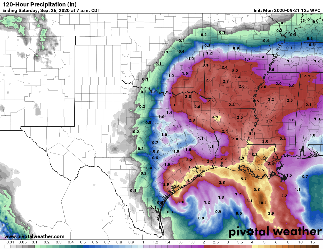
Due to the aforementioned dry air, we do not expect prolonged periods of heavy rainfall across most of the area, however we cannot rule out some training rainfall in isolated areas. Between now and Wednesday, our best guess remains that areas south of Interstate 10 will generally see 2 to 6 inches of rainfall, with areas north seeing 1 to 4 inches. However we probably will end up seeing some 10-inch bullseyes over the region. There may be some spotty flooding associated with this, but for the most part our area’s bayous can handle these kinds of rains. We’ll remain vigilant for any changes to this forecast.
Winds
Winds over the area likely reached their maximum extent early this morning—Galveston Fishing Pier reported a gust of 49 mph shortly after midnight—and should gradually wane later today. As we’ve been stating, Beta is a not a significant wind threat.
Weather ahead
Both Monday and Tuesday will see a high chance of rain, as bands of rainfall from Beta move onshore. Some training will be possible, but there also should be breaks between rainfall. Our biggest concerns for heavy rainfall are in Brazoria and Galveston Counties, where roads near the coast may already be submerged. Please do not drive into high water today. Highs likely will range from the upper 70s to low 80s. It’s worth noting that Sunday’s high temperature of 78 degrees was Houston’s coolest day since May 9th.
Wednesday should be somewhat of a transition day as Beta lifts away, to the northeast. We probably will see some trailing showers, but the threat of very heavy rainfall should have ended by then.
Thursday, Friday, and Saturday
The second half of the week should see the return of sunshine and, accordingly, highs in the 80s or low 90s. It will be a good time for the region to dry out
Cold front?
Our best global models indicate that a reasonably strong cool front will push into Houston early next week, perhaps around next Monday or Tuesday. It’s still a long way off, but the signal for this front is reasonably strong—we’re hoping to be able to celebrate Fall Day around before the end of the month, when nighttime temperatures in Houston fall to 65 degrees or cooler. So, fingers crossed!
Our next post will come no later than 2:30pm CT Monday.

I live on Chocolate Bayou in Brazoria County. The water is way out of the banks and almost in the bottom of my house. We have had very little rain, this is all tide.
All Tide and storm Surge.
I respect SCW so much! You are my go-to guys when sever conditions threaten. Thank you!
Thinking of Matt and his growing family. Hope y’all are well.
Thank you for the morning update, and the continuing reassurances that we’re not dealing with Harvey 2020. Adding my best wishes for Matt and his family too!
Thank you! And congratulations to Matt and growing family 💖
Thank you! And congratulations to Matt and lovely family 💖
Thank you again for your no nonsense honest updates. My go-to site for weather info. First thing I checked this morning. Prayers for Matt and his family.
Congrats to Matt and family, and as always, thanks, SCW, for being the Sgt Joe Friday of the weather works: “Just the facts, ma’am.”
You didn’t update us on baby. Hope all is well. XOXO
Thanks again! I drive to work (as a buyer for a big national grocery store chain) and count on your posts to help me figure out which way to drive there (and to help alleviate my own PTSD from my experiences during Alison and Ike). Cheers! And congrats to Matt and his family!
Thanks for the update, Eric. Best wishes to the Lanza family.
You guys are super duper. Thanks a bunch. MilesGlaspy
Comparing your level-headed forecast with science based opinions to the shrill panic-inducing reporting of The Weather Channel makes me want to call one of the Billboard lawyers in Corpus Christi and ask them to file a “Meteorological Malpractice” action against TWC. Thank you and keep up the sound hype-free analysis.
I had a nice day yesterday instead of panicking. We really, really appreciate this site. I’ve been reading Eric since before we moved to Houston — in fact, I decided that a community that had a “science guy” column in the newspaper was the kind of place I would want to live. It really was a factor for me!
Sadly, the Chronicle no longer has a Science Guy. But he’s still here in SCW and Ars, so that’s still great. And the newspaper sill likes to quote Eric and Matt.
Almost exactly one year ago, Houston had Imelda, which was not hyped up by anyone but flooded some neighborhoods that hadn’t flooded in Harvey or Allison. The streets around here were a mess with water covering the entire road bed. METRO stopped running buses for most of the day.
Best wishes to Matt and family. I love you all. Thanks for your dedication and your honest reporting.
Eric,
Great call. This Beta nothing burger is bringing welcome rain and cooler weather.
In the Meyerland area there has been about 2″ of rain in total since the first band came through Sunday afternoon.
I recall when you introduced the influence of dry air on tropical storms back in the SciGuy days and when I saw your graphic of the huge mass of dry air NW of Beta, it was clear that we would not have a repeat of the 2017.
Keep up the great work!
Boy or Girl? Hope everyone is well. We need some rain anyway 😎
For old-timers, a slow-moving rainmaker brings memories of Tropical Storm Claudette in 1979.
Oh, i’m from Alvin please don’t mention Claudette…..I still remember floating down our street in our red wagon….
This is my first time reading yall’s weather report & I absolutely ❤ it! I dont really follow local or mainstream media news for their panic inducing/negative reporting styles so I’m usually outta the loop when a storm’s in the Gulf…thanks for the trust-worthy update!
Great idea to post the side-by-side images of Beta and Harvey to show why this isn’t a similar flooding concern. “A picture is worth a thousand words”.