Good morning. Winter Fest 2021 has arrived in Houston, complete with frigid temperatures, snow, sleet, freezing rain, howling winds, and power outages. It is everything we expected and dreaded.
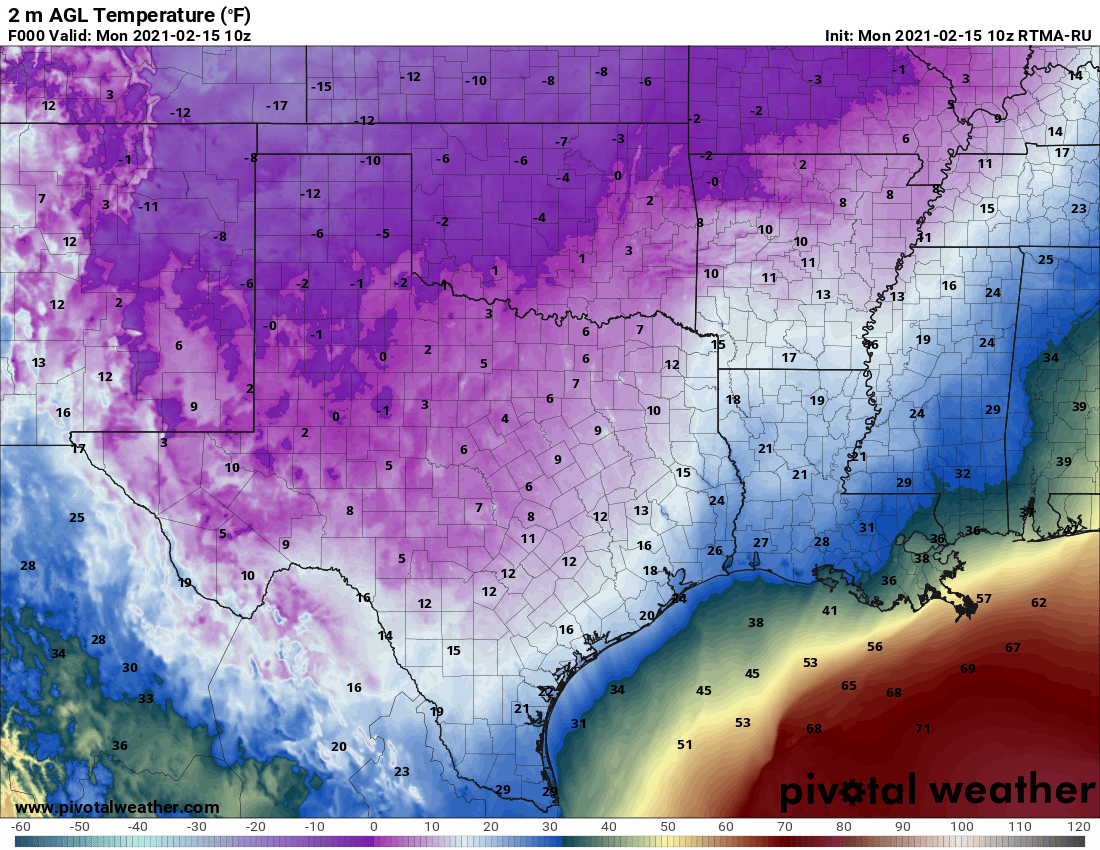
An extremely cold air mass has descended upon the area and dropped temperatures to 20 degrees or below for nearly everywhere, including the coast. With the wind chill, it feels like 0 degrees for inland areas and 5 to 10 degrees elsewhere. Wintry precipitation overnight, a combination of primarily snow and sleet, has covered most area roadways with a sheen of ice. Travel today is a bad idea.
Monday
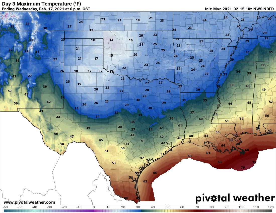
High resolution models show precipitation ending from west to east this morning, and likely moving east of the Houston metro area by around 9am. This will not preclude the possibility of some snow flurries redeveloping later this afternoon. Unfortunately, temperatures are unlikely to recover much today, with highs perhaps in the low to mid-20s across the region. The ice on roadways is not going anywhere, any time soon.
We still expect an extremely cold night across Houston, with temperatures likely ranging from about 5 degrees over inland areas to around 20 degrees along the immediate coast. These will be the region’s coldest temperatures since at least 1989, and for some areas possibly much longer than that.
Tuesday
After a bitterly cold start to the day, sunshine will help lead to modest warming as winds shift to come from the east. By Tuesday evening, we anticipate that temperatures will climb above freezing for areas south of Interstate 10. Temperatures on Tuesday night really will not fall much as the onshore flow kicks in.
Wednesday
Sunshine will go away by Wednesday, as moisture levels rise in the atmosphere and the next front approaches. Most of the metro area should reach highs in the upper 30s to low 40s on Wednesday (the coast will be warmer still), although areas north of Conroe may remain stubbornly near freezing. As precipitation chances increase on Wednesday, it appears that most of the area will see rain, but we have concerns about freezing rain in Montgomery County, and points north, both on Wednesday morning and any lingering showers Wednesday night.
Thursday
Another very cold day, with most of the region likely only reaching a few degrees above freezing. However, we think this probably will be warm enough to melt any ice on the roads by mid-morning or so in the metro area, with some caveats about the potential for lingering ice near and north of Conroe. Much of the area will see a hard freeze on Thursday night, with lows dropping into the 20s.
Friday, Saturday, and Sunday
As high pressure settles in we’ll finally a see a definitive warming trend heading into the weekend, with highs in the 40s on Friday, and reaching the 60s for most areas by Saturday.
Power outages
There are two sets of power outages this morning. One is due to ice accreting on power lines, and this is affecting about 5 percent of homes in the Houston area. In addition to this, there have been rolling blackouts ordered ERCOT across the entire state that should last about 15 to 45 minutes at any one location.

If our power has been out since 2:30, but not showing on center point outage map, how can we report? Phone call and web reporting systems both down
We are in the same boat in Fairfield out in cypress. At least the snow is beautiful this morning.
At west park/1464 it Was off and on 1-3am, but those showed on tracker. Since then it’s just off and can’t get any idea what’s going on. Tracker shows we should be restored – have they forgotten to switch us back on after rolling blackout?
Same in Pearland. No outage on the site. 800-number isn’t working.
We have been without electricity since 5AM in The Woodlands. It is very cold in the house. No one is telling us what is going on or when power will be restored. I don’t believe this is a “rolling” blackout for such an extended time.
Call this number
7102072222
Not the 800 number, worked for me. My power has been out since 2 and still not showing on the map, though
doesn’t work…. ask for a pin #.
It’s 713 207 2222 looks like a typo
Let’s take a moment to discuss power equity. In these series of comments…(1/47)
Power in Montrose has been out since 2:20. I’ve tried calling, and mostly can’t get through.
Where in Montrose? I live by Dunlavey/Westheimer and haven’t lost power
These power outages are lasting hours. Don’t think we are damage related. But been out since 2am near ikea in hilshire village
Doubting this is a planned “rolling blackout”. 3.5 hour outage so far in Galveston (77554)
Airports- for those flying in/out on Tuesday – Thursday— I imagine all flights have been cancelled for Monday and Tuesday. What are the chances the airports open Wednesday? I’m trying to get home to Montrose.
Power out since 2 in Texas city 77590
East Bernard TX is also without electricity
Power out in West U since about 2am. While half of West U shows up on the outage map, we do not. Currently 57 degrees in the house and dropping.
Thanks Eric!
Same in Atascocita. Out since about 2 and not on the map.
Many Montrose-area residents have been without power since 2am, and the Centerpoint website and outage phone line have been non-functional since then (nor have we gotten outage alertts by text).
Yes. Same in mont Belvieu. We need updates.
Power out in North Fulshear (Jordan Ranch) at I-10 since 8:30 pm Sunday.
Power out in Independence Heights as of 5:45am. Hoping it won’t be for too long. Tried reporting on the outage hotline (713) 207-2222, but it wanted to connect me to a representative, said it couldn’t, then hung up on me. Not sure it registered my report. 🤞
Looks like the powers that be (get it? powers?) declared rolling blackouts to be longer than originally anticipated. I would expect a lot of the power to be restored later in the morning.
https://www.click2houston.com/weather/2021/02/15/track-power-outages-during-the-winter-storm/
Power out in Tomball near Hooks Airport since 2:30am. Outage map from CenterPoint does not show it. Their outage map is a JOKE!!! And trying to call them before 7am is an even bigger joke!
Being a veteran of living in the Snow Belt in Ohio growing up, I’ve seen thundersnow 2…maybe 3 times in my life. I saw it at least 6 times last night. Pretty impressive. It was so bad the dog hid in the bathroom.
Power out in Waller since another 7:30 Sunday night. Came back on briefly around 10:30 , then back off. It’s damn cold ya’ll.
Conroe is pretty much without power too
No power since 5:20 in league city (that’s the time stamp on the “hey, I lost power” email from my UPS battery thing). Cellular internet is getting super unreliable as more folks wake up and try to use their phones, too. Sucky morning.
What part of league city? Im at 96 and south shore and haven’t lost power yet
I’m at 96 and SS; our power went out at 2:30, back on for about 30 minutes around 8 and has been off since.
Power out in League City since before 3am.
Centerpoint website so broke it won’t even accept money to pay my bill 🙁 .
No power in Clear Lake/Pasadena. I think it’s been off for more than an hour.
Some parts, I live in pasadena and havent lost power at all
No power in Moody Gardens Golf Course area since 2am. CP # just tell me to have a good day 😂
Power is now out in northeast Third Ward near UH as of about 8am.
What gives with no power and no communication? Need accountability.
Need better infrastructure. Nineteen degrees causes no issues in the Midwest.
Infrastructure goes both ways. We seem to have more people on electric heat down here. That’s not good.
Even those with gas (forced air) heat are without now. Space heaters being the only way aside from a fireplace. This is such an unusual occurrence most don’t wanna pay the price for something so rarely needed. And most do come through it. Uncomfortable? Well YEAH. But we live. Mother Nature can and DOES one up any and everything man does in the attempt to conquer her. We should have learned that by now. Hurricanes anyone? Mud slides? Earthquakes? Tornadoes?
What? Lol gas heat here, a nice 74 in the house
The difficulty that electrical repair crews are having getting around can’t be overstated. Crawling from place to place and unable to go up the slightest incline. And climbing a pole and working in extremely cold temps with high winds is another “gotcha” they face. We can all hope for no more precipitation (doubtful) and a faster than believed thaw. (also doubtful) Many thanks to the crew at Space City Weather. You cave us ample warning and MOST took heed. But there are things simply out of our (and anyone’s) control. Best of luck to all.
What does this mean for road conditions tues-thurs?
To everyone who is complaining about this being a broken system and phones not working….Don’t you think they are doing all they possibly can considering this is not the usual operating conditions?
So much of this is out of anyone’s control.
Pray for them as they are likely very stressed out and struggling to manage a very very difficult and widespread situation. Perhaps if you were a current employee out there fighting this battle you would see things differently.
I agree. And how many are willing to pay the cost of an infrastructure built to handle weather situations that occur so infrequently? And let’s not forget COVID and its effects are still very much with us.
Why the Texas power grid is choked in winter, not summer:
https://www.wunderground.com/video/top-stories/how-winter-storm-uri-choked-texas-power-grid