Good afternoon everyone. I’ve been watching the models and observations all day, and we look to continue walking a fine line between ice, an even mix of ice, sleet, and snow, and a bigger snowstorm in the Houston area. Not a whole lot has changed from Eric’s detailed morning post, but let’s freshen up the forecast a bit based on what we’re seeing right now.
Now
As of 4PM, here is a map of where temperatures are currently below freezing (locations above freezing not shown).
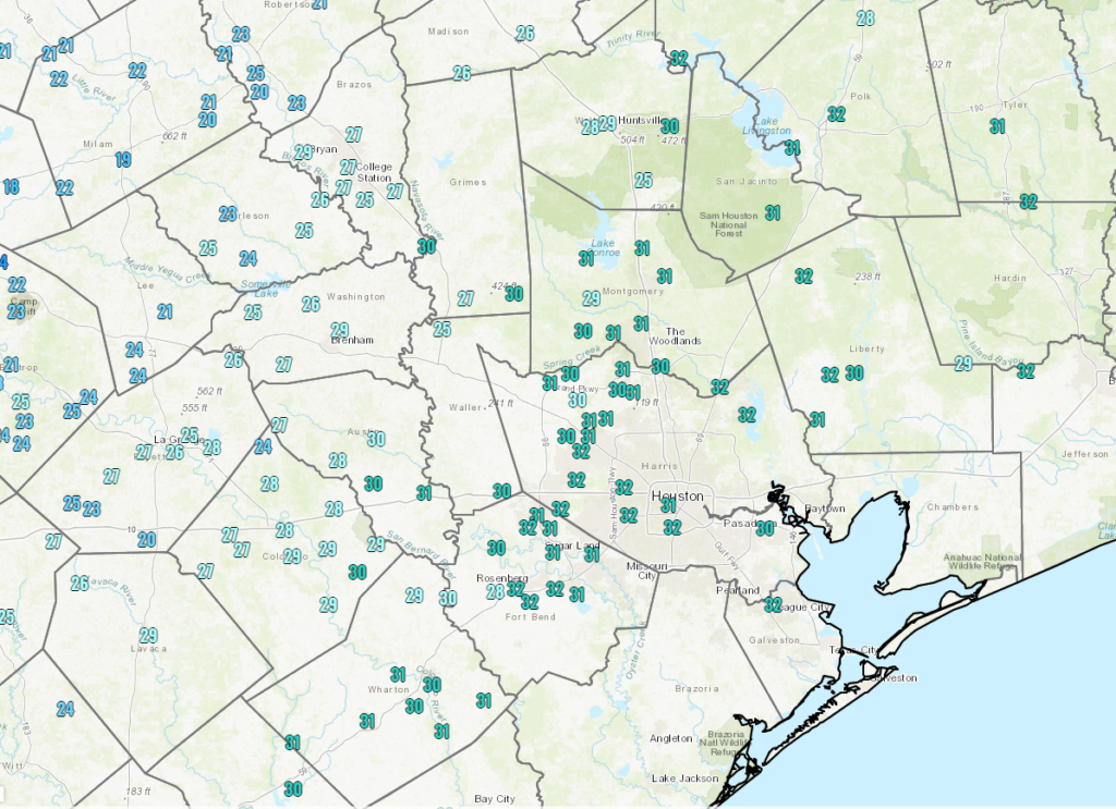
So, if we roughly overlay that freezing line on radar, you can see where the risk of ice is at the moment I am writing this.
Basically anywhere along and west of US-59 and north of I-10 is at risk for icing on roadways as of now and worsening over the next 2-3 hours.
Through Midnight
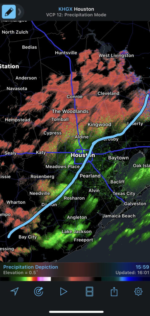
Over the next few hours, watch for rain, freezing rain, and freezing drizzle to overspread most of the region. Temps will continue to glacially drop off slowly, eventually putting everywhere but probably the immediate coast below 32° by midnight. Ice accumulation should not be significant in terms of weighing down trees and power lines this evening, but you’ll begin to notice a glaze on most outdoor surfaces, and travel will become hazardous to impossible across the entire region.
Midnight to 7 AM Monday
Two things will happen after midnight: Colder air will speed up its arrival in the area and the precipitation should become more organized and heavier. Our forecast confidence begins to drop off here, but theoretically, this should mean that freezing rain will transition more to sleet and eventually snow. That transition will take place from northwest to southeast and where the precipitation falls heaviest.
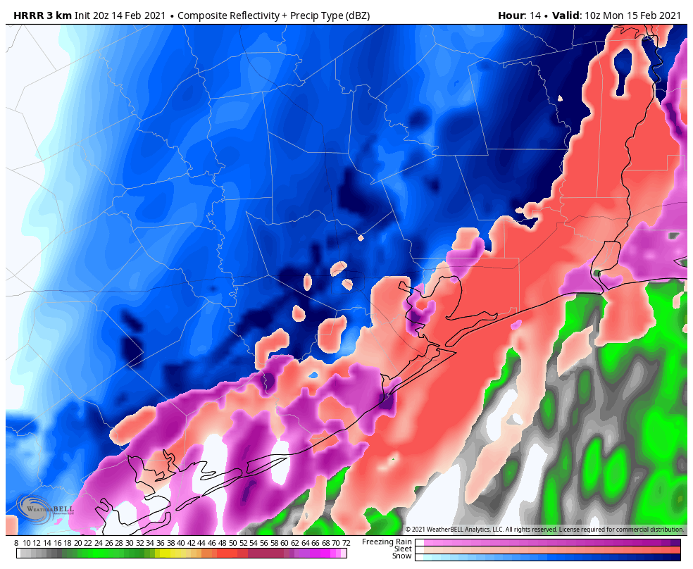
This is when we will probably start seeing and hearing reports of heavy sleet and even heavy snow in parts of the area. I’ll be honest, as a Northeast native, what is being depicted on some of the models is the potential for bonafide, real deal heavy snow and/or sleet, particularly north and west of Houston (think far NW Harris County, Montgomery County, College Station, Huntsville), but perhaps in the city or even some places east of the city too. We’re talking potential of 1-2″ per hour snow rates if we flip over. If the warm layer a couple thousand feet up holds, then heavy sleet will the story, and we’ll see 1 to 2 inches total of “cement” on roads and surfaces.
Quick note and reminder: If we end up with sleet or sleet/snow accumulation and you have to shovel or clear surfaces, please take it slow and take it easy. There is a known link between shoveling snow/sleet and heart attack risks, to the point where hospitals up north often staff up for that very reason ahead of storms.
7 AM to Noon Monday
Precipitation should begin to wind down from west to east before Noon on Monday. Most places will end as a period of snow or flurries.
When all is said and done, expect 1-3″ of snow, more northwest, less southeast. Expect a tenth to a quarter inch of ice, more southeast, less northwest. Higher amounts are possible in either case.
Monday afternoon
Despite the precip ending, conditions won’t improve much. It’ll remain quite cold and any chance of sunshine will probably hold off til late day or Tuesday. Eric will update you on that chance in the morning. Either way, we won’t be getting above freezing on Monday, so whatever falls is going to stay in place through the day and into Monday night.
Monday night/Tuesday morning.
No big changes to the forecast for Monday night and Tuesday morning. It will be cold, likely damaging cold. Please make sure you’ve finalized all preps for pipes and plants by now, and look out for pets and neighbors.
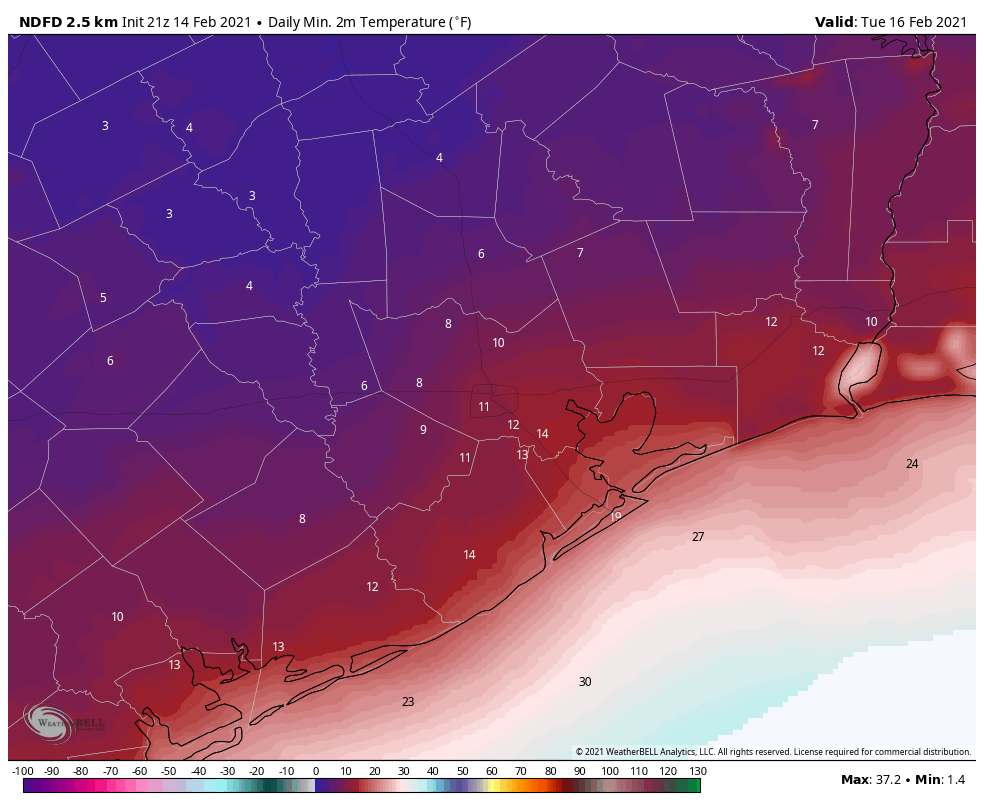
There’s still a tad bit of uncertainty on exactly how cold we get, contingent on how many clouds remain, how much snow falls vs. sleet/ice, and how windy it is. But either way, a damaging, destructive, probably historic freeze is on the way Tuesday morning.
Tuesday afternoon and beyond
Look for slowly rising temperatures Tuesday, probably close to freezing from I-10 south and just shy of it north of there. We should have sunshine, and that will allow for some melting to occur, but there’s a chance most roads remain sloppy to impassable most of Tuesday too.
And then beyond Tuesday, I don’t want to speculate too much still, but it does look like Wednesday’s storm will be a mess for northern fringes of the area. The potential exists for a serious ice storm north of Houston (probably plain rain in most of the Houston metro itself). Coastal locations may even make a run at 50+ degrees on Wednesday. Between storm track issues and potential snowpack issues (keeping temperatures cold), there is a lot we don’t know about Wednesday. Look for an update by about 5:30 in the morning from Eric.

Thank you Eric and Matt for all you do. Is it safe to go swimming tomorrow?
Polar Bear challenge!!
Thanks for your incredibly right-on new service. Your app is the only place i look nowadays for weather news😀
Bless you, Matt, and Eric for keeping us so informed. Location specificity is incredibly helpful in planning for the storm. Be well and stay warm!
Thank you SO MUCH for all your updates!
Greetings from Boston, Matt and Eric. Watching your situation closely; it’s par for the course around here, but not for you! Hunker down and stay inside; temps will moderate as the week goes along, but not before you have to deal with this mess. This system will be visiting us on Tuesday. We’re ready! Keeping you all in my thoughts.
I got my faucets and outdoor spigots dripping and I wrapped the little bit of outdoor exposed pipe. My main worries are pipes freezing and power outage, whether from ice or rolling blackout. My house has never endured this level of prolonged cold, so we’ll see. Too stressful…
And then this summer we get to dodge multiple hurricanes again!!!
Such a fun place to live.
Add in the COVID stress too…..
Eric and Matt, thank you for your work on this storm! It is very much appreciated!
FWIW, one of the forecasts is now showing above freezing Tues, well above on Wed, and 60’s by the weekend.
Tough call, there. This is a very hard place to make a quality forecast!
Does the part about Tuesday roads and freeze apply to Fredericksburg area too? My sister was traveling back to San Antonio and is stuck there (thankfully in a super 8 at least). Trying to help her determine when it’s safe to try and drive again, I said maybe Tuesday afternoon??
Remember it takes a number of hours above 32F to thaw out. She’s just going to have to wait and see how things unfold.
Thank you! I’ll share that
Looking better for the power lines. Just hope the plants are staffed up without any down for turnaround like about 10 years ago.
At least we aren’t getting 12+ inches of snow this week like forecast for back home.
I know you don’t have a crystal ball, but here’s my question. We didn’t risk driving home to Tomball from Llano today. Any idea when you think I can come home?
In Katy. Just south of 10. Lost power about 10 minutes ago.
Here’s a new tip I had not seen before from the guy who installed our water filter system (outside the house and made of metal!) The company actually came out and wrapped it for me this week, but I like this tip because it gives you a way to monitor what may be happening inside your pipes….
To prevent ice damage, use the heat that is already in the water to keep ice from building up in your filtration system.
Today the temperature of Houston’s City water is 54*F.
Run a small stream of water continuously into a cup placed in the kitchen sink. Place a thermometer in the cup and if the water hits 35*F or below, increase the size of that stream.
You may have to run the cold water in your bathtub at full blast for a minute in order to melt any ice already formed in your pipes.
Thank you for your updates! The tv newscasters are so frenzied that it helps to see rational point-by- point weather forecasting/reporting.
I won’t be watching the local news for several days. I’m stressed out enough lately. Pipe insulation repairs finished, plants inside. Just keeping fingers crossed for power, which I have no control over.
Thank you for the updates. I hope the storm threat turns out well for everyone.
Question: I prepped my plants (mostly bushes and greenery) early with sheets. The rain came in today and soaked them. They’ll likely freeze overnight and tomorrow. What harm to the plants can I expect when I remove the sheets when it begins to warm up again?
I was listening to a radio show on Saturday that deals with garden topics. The host said that ice on the coverings actually protects the plants.
Thank you for all the updates, I can’t stand the hype and hysteria on the local TV channels when it comes to a storm here.
Wrap outdoor pipes with Christmas lights (the old incandescant type). Cover that with a towel to keep the heat in, and cover that with plastic to keep the towel dry. Works like a champ! Makes you wish you’d kept your old lights when you bought the LED’s, huh?
Thank you so much for your user friendly weather interpretations. Several years ago when we were cruising our sailboat through out the caribbean we had the great pleasure of getting our advice from a weather router. You all remind me of listening to Chris Parker on the SSB as he shared his weather insights and outlook for each boat subscribed to his service.
I feel very good knowing that we can get real no BS weather. It’s the only way to prepare if something is coming at us.
Thank you.