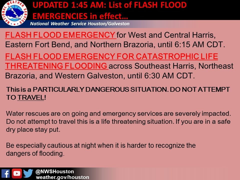
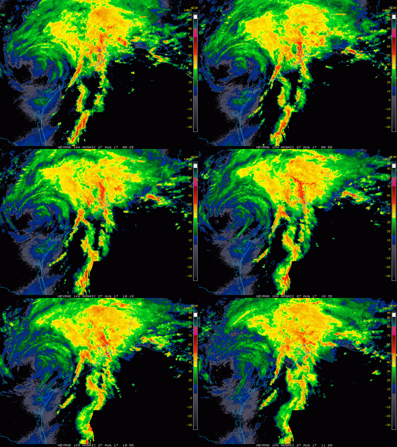
Good morning. Heartbroken and sick over some of the news and stories this morning. Thoughts and prayers go out to everyone affected. Unfortunately we need to talk about the weather, as this will continue.
Off the top, we can’t tell you much more than to follow instructions of local government, NWS Houston, and Harris County Flood Control. Stay tuned to a media outlet using radio/TV.
A Civil Emergency Message has been posted regarding folks trapped in their homes.
Via NWS Houston and Jeff Lindner: Residents trying to escape rising floodwaters should go on their roof, do NOT go into the attic. Also if calling 911, stay on the phone until it is answered.
I am directly copying Eric’s words from overnight here:
“Speaking of that, for the first time ever, the National Weather Service just issued what it is calling a “Flash Flood Emergency for Catastrophic Life Threatening Flooding.” And not to sound too flippant, but that sounds really bad. You should probably heed their advice—WHICH IS SIMPLY DO NOT TRAVEL. DO NOT IMPEDE WATER RESCUES IN PROGRESS.
Is that clear enough?

If you home has flooded, then we are truly sorry. No words from us can begin to address that problem. But we can say that millions of people have been through this before, and it can be done. Some good, basic advice, can be found here. And although this handbook from FEMA is dated, it provides detailed steps to take care of yourself, your family, and your property in the aftermath of a flooding event.”
Weather going forward
As of 6:30 AM rains continue to fall heavily, at a rate of 1-3″ per hour in spots.

Over the next 12-18 hours, expect this cycle to continue. Waves of rain, heavy at times. There will probably be breaks. What this does is both limit how bayous can drain and worsens flooding in spots. It’s bad and it’s going to likely stay bad through the day. Some folks may see another 6-12″ of rain today and tonight.
Rain will continue in similar fashion on Monday as Harvey drifts south and then begins to make the turn back north. The setup begins to change a bit on Tuesday, but at this point I still think periods of heavy rain are likely. Harvey should finally move far enough north on Wednesday to not shut off the rain, but reduce it to manageable levels.
In addition to the rain, Tornado Warnings continue cropping up from time to time. This threat will continue through the day today, with hopes that it will be at a slower pace than the last two days.
We’ll have another update around 9 AM or so. Please be safe.
Posted at 6:40 AM Sunday by Matt

Thanks guys. 15.5 inches so far. Our thoughts and Prayers to those in harm’s way. God Bless our first responders!! Really appreciate you guys and what you do!!
Thanks Matt
Great job
Thank you both. You are truly a life-line during these times. Appreciate all you do.
At times like this your thoughts turn to your friends, although I have never met either of you, your tireless efforts over the years to keep us up date puts you in the group of people I would call friends. I hope you and your families are out of danger. Or as out of danger as you can be in the Houston area right now.
I never thought it could get this bad, I’m on DefCon I and hoping for the best. Not in a million years did I ever once think I would be bringing an axe in my house with the thought of cutting through the roof.
Once again, let me offer my sincere thanks for what you are doing for us all. This must be extremely difficult, on many levels, for you all to continue to offer this needed information. It’s greatly appreciated! Please stay safe (and sane!). Try to have as good a day as possible.
Turkey creed in 77008 have overflowed its banks and flooded housed at the end of my street. The water covers most of my yard and is rising. This house flooded in Allison.
yep. they’re saying that the rains for the brays has exceeded memorial day flood levels. they are going to exceed it on the keegans bayou where I am. so far dry in house. amazingly still have power. how long that’s gonna last under this deluge is anyones guess.
Very blessed to be on the third floor of my apartments. Watching my parking lot with trepidation but I’m in the highest spot. We moved my roommate’s car to a parking structure just in case mine does flood. We have power, thank goodness.
I do have a question though. With this much water, is municipal water unsafe to drink? Should we be boiling our water? We have water rations but while we still have electricity I’d prefer not to break into them.
If you have trouble accessing “Before, During and After Flooding” at the embedded link above, try a cached version at the Internet Archive, e.g. https://web.archive.org/web/20161126161512/http://www.susquehannafloodforecasting.org/before-during-after.html Stay safe, all!
Thank you so much for all you do. You’ve got plenty to deal with personally, and you’ve taken a lot of time this past week to keep us all updated. Thanks to your families, too, for giving up all this time with you for our sake.
Many thanks also to Centerpoint employees who have been out in the middle of all this working to keep and get power on.
I know this sounds like a broken record: Thank You, Eric and Matt. It is comforting to be able to read about the weather in a no-hype manner. When you start your next money-drive I will contribute.
Before I went to bed early this morning, I was reading that the storm might loop back and hit Houston again around Friday? Is this still a possibility? Thanks for your instruction and reassuring words. I hope this type of info is getting out to people who need it the most right now. I’ll be sharing this post everywhere.
THANKS SO MUCH FOR ALL YOU
Matt, thanks for your coverage. Regarding the new NHC forecast path, if that materializes and the remnants of the core pass directly over Houston, do you think the winds will be strong enough to uproot a large number of trees given how wet the ground will be at that point?
We’re in south Louisiana trying to get home to Houston. Any thoughts about the possibility of travel along I10? When can we drive safely to Houston?
As hard as this will be to hear, don’t come back yet. There’s virtually no chance you make it home without hitting at least one road that’s completely impassable. I think you’re looking at late this week, at the earliest. There’s just too much rain coming now and still to come.
Seems like there is a heavy band Just beginning to hit the Metro area now. After that, the radar seems like it is going to clear up for a bit. Am I reading things correctly.
You should monitor a couple of websites. First is drivetexas.org’s information about road closures. It’s as up-to-date as you can get:
http://conditions.drivetexas.org/current/
That will help you understand what roads are already (or still) impassable.
The next is the NWS Houston office’s river flood statementsHere’s a link to the text version—a lot to wade through, but faster to get to and less demanding on Web servers to deliver. Check the story for the rivers, creeks, and bayous along your route. Its advisories are excellent about telling you not only the current level of the stream but also what levels are expected, when they’re expected, and specific impacts of each level. For example, an advisory would say something like this: “Wide Creek at Highway 1: Current Level 10 feet; Flood Stage 15 feet. Expected to rise to 15 feet by midnight. Continued rise to 19 feet by noon tomorrow. At 15 feet, low-lying pastures along the stream will flood. At 16.6 feet, Expensive Estates is cut off. At 18 feet, Highway 1 is Impassable west of the bridge. At 19 feet, low-lying homes in Trailer Parque begin to flood. With no further rain, Wide Creek will begin falling by midnight Wednesday, reaching 17 feet by noon Thursday and bankfull stage by Friday evening.”
OK, so I overdid it. But it really is that specific.
Then, of course, keep an eye on rainfall totals at and upstream of your route of travel.
All anyone can tell now is that the whole area will have lots of wind and rain for at least several more days, The anticipated track of the storm has changed at least twice in the last 24 hours. With the weak steering currents, even small changes in atmospheric conditions will lead to big changes in the predicted path and pace of the storm, so no one can give you an accurate prediction of what specific roads will still be passable four days from now.
To be fair, the local government officials telling folks not to travel are the same ones who said it was safe to stay in the first place.
Their judgment is suspect.