As of this morning, not much has practically changed, with widespread flooding continuing and heavy rainfall continuing. Please see our previous post for a re-hash of safety information I think everyone has heard to this point.
Now & Today
As of mid-morning, we continue to see waves of rainfall push through the area.
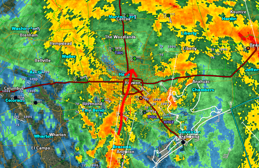
Over the course of the afternoon, expect the pace of the rain to perhaps slow down a bit. This isn’t being optimistic…this is actually rooted in some of the weather models. We’ll continue to see widespread flooding problems, but any opportunity to slow added rainfall will help slowly drain a little bit of the water out of the region. Every little bit helps.
The heaviest rainfall today will occur north and east of the city it looks like. We’ll continue with isolated tornadoes.
Tonight & Monday
The nighttimes are when we are most vulnerable. Unfortunately tonight doesn’t look ideal. I don’t necessarily expect a repeat of last night, but even if half of what fell last night occurs tonight, there will be a recurrence and worsening of flooding in spots (perhaps not everywhere, but definitely in parts of the Houston region). Weather models indicate another substantial amount of rain is possible through tomorrow afternoon. Bottom line: You have to plan for another difficult night tonight and day Monday.
Beyond Monday
Harvey’s forecast track remains difficult to perfectly pin down, but a general drift south and east through Tuesday before it finally starts lifting north Wednesday and Thursday.
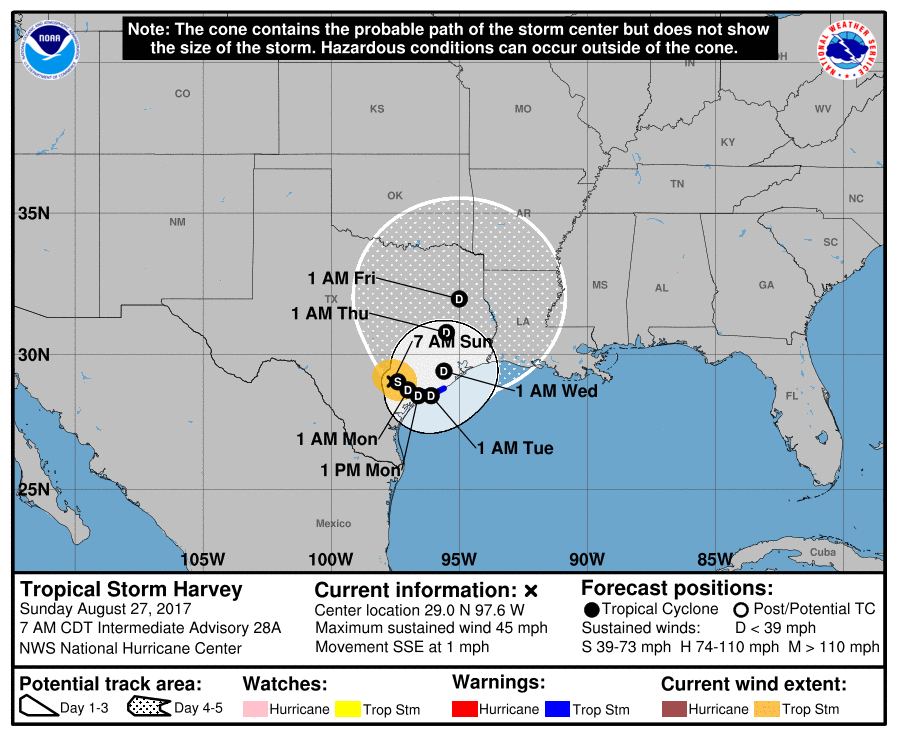
There may have been rumors circulating about Harvey pushing back out over the Gulf and reforming into a storm or, especially a hurricane. While the storm’s center may reemerge into the Gulf, we feel that significant strengthening is unlikely. For now, there is little need to worry yourself further about storm surge or very strong winds in an already awful situation.
As Harvey lifts north later Wednesday and Thursday, the rain won’t shut off, but it will become more sporadic and manageable. No, it doesn’t help, but we should hopefully begin the long road of recovering. Another update later this afternoon. Be safe.
Posted at 9:55 AM Sunday by Matt

When do you think it will be safe to drive into Houston from out of town? How is road flooding looking? I am holed up in Austin currently.
Thanks again, you guys, for the coverage.
Houston TransStar is showing flooding on all the major Houston roadways. I’m guessing that travel will be extremely difficult or impossible until after Harvey moves and Houston is out of the major rain bands.
I just posted a pretty detailed answer to that question. If you go to the replies to Matt and Eric’s previous posts, you’ll find links to several websites that will help you answer that question. I’ll add another for people who, like you, are planning to return to Houston from Central Texas:
http://water.weather.gov/ahps2/index.php?wfo=ewx
Also be aware that many areas near Austin have flooding of their own. Ceck the road conditions all along your planned route.
As always, THANK YOU!!!! All the work, dedication, and true caring for the people you are doing this for is amazing.
Now….if you could please get the beast to move a a miles or so east to give us a break that would be great. I doubt you can do that so I will trust in your forecast and maybe not have as big a knot in my stomach tonight.
Thanks for helping us get through this, Matt.
Many thanks to all at Space City Weather!
Thanks for the continued updates. You were mentioned in the New York Times! Also I am furious with employers that are requiring employees to drive to work today. My son will be driving from Humble to Huntsville for a non essential restaurant job. Shame on that employer.
Agreed. I live in Katy, but work overnight in Sealy. The water levels would allow me to drive to work, but i wouldn’t feel safe driving 39 miles home at 3 am.
Thanks for a calm and rational weather report. Need to let my boss know I won’t be traveling to CA tomorrow.
I wrote three days ago and noted this could be the worst flood in our history. Eric replied that he didn’t think so. I now write to argue against you dismissing the in the gulf and storm option. Joe bastardi , who has been on target for this, calls for a cat 1 hurricane
Totally agree
Matt, Eric,
Thank you for all the excellent work you do on our behalf! You have been amazing throughout this!!!
When you say heaviest rain will be north and east — anything more specific as to cities/subdivisions?
Ahhh it’s not patently false, several models are indicating the possibility. It’s patently possible . Disappointed in your statement, maybe your just tired . Keep up the good work otherwise.
A couple of items to note…
I read estimates that we could easily top 1 trillion gallons of water from this event. Allison, if I remember correctly, hit around 300 billion estimated.
Water vapor loops show a nice slug of dry air pulling in from the NW. Hopefully this will shut of the spigot for a while.
The same imagery shows a nice twist in the atmosphere that is moving west near Cuba. I have been watching it for a few days, hopefully it doesn’t try and develop.
You’ve been wonderfully, wonderfully informative and I thank you for that. Could you go into a bit more detail about why we shouldn’t expect Harvey to move back into the Gulf? I haven’t a clue about any of this, but I keep seeing meteorologists posting models suggesting this could happen.
I believe Matt meant that the storm’s intensification back to TS or hurricane status over the gulf is the part to not worry about, not its actual track.
“Patently false?” Patently means clear, without doubt.
There is still a lot of confusion and doubt over the Harvey 2.0 theory.
In this same post, you stated “Harvey’s forecast track remains difficult to perfectly pin down, but a general drift south and east through Tuesday before it finally starts lifting north Wednesday and Thursday.”
Also, the National Hurricane Center has forecasted the eye moving down south towards the gulf: https://i.imgur.com/oaYxGKt.png
Most models are now supporting the second landfall model and is actually the NHC’s official model now.
Space City Weather has been repeatedly wrong at every stage of this storm. Didn’t you say that Houston would only get 6 inches of rain last night?
“Patently false” is a strange phrase to use. The weather is simply not predictable in that sense; everything is models, nothing is 100%. The GFS model just came in line with the EURO, so it’s looking more (and not less) likely that the center will come back over water.
At any case, there is nothing clear and obvious about this situation.
Looks like the post has been edited. Either way, that model doesn’t show the storm re-strengthening and picking up wind speed. So while we are still in for a boat-load of rain, it is still looking unlikely that we will receive a hurricane-level landfall with life-threatening wind speeds and storm surges.
Eric, Matt & Braniff,
Words cannot adequately express my appreciation for your dedicated service – especially the last few days. Hype has been running wild on so many channels, it is refreshing to be able to count on your steady analysis. Eric, your 2:11 AM post last night was really heartfelt. Thanks again and keep up the good work.
How are we looking in the Beaumont area?
Thank you so much for your work.
I am concerned about our water. Is it still safe to drink?
I see you removed and clarified the “patently false” statement in your text body above. Much more in tune with the forecast models.
‘Wrong at every turn?’ They said ‘the rain won’t hit the city at its strongest till Saturday night and into Sunday.’ Sounds pretty damn accurate from where I’m sitting.
They called for 15 to 25 inches of rain over five days. My local gauge has me at 15 after 2 days with 10 inches to go before Wednesday. Again, pretty damned accurate so far.
This site has discussed each model in turn thoroughly, coherently, and rationally, and has assigned them probabilities. The thing about probability is, even if something is a low chance, it can still happen, and even if something is a high chance, it might not happen. That’s how casinos get people in the door.
So far, I find the reporting here just as solid as it has been for the past eleven years that I’ve been following Eric’s reports. *shrug*
@Deborah,
Spot on! Complete agreement with your counterpoints.
Agreed. I live in Katy, but work overnight in Sealy. The water levels would allow me to drive to work, but i wouldn’t feel safe driving 39 miles home at 3 am.
I agree with Deborah…
Matt,
Can you please explain why this is: “The nighttimes are when we are most vulnerable.”
Thanks,
Chris
Here’s an example I can think of. When driving at night, you can’t see the water on the road or tell how deep it is. You can drive into flooding way more easily at night.
Do you guys have any idea if roads going to austin from spring texas would be passable? I need to catch a flight on aug 30
Paul, you can check out road conditions, including not just flooding but construction and closures of any kind, at drivetexas.org. You can even change the settings so you can look at future closures or delays due to planned construction.
As I type this, if you were to take Loop 99 to US 290 near Cypress and take US 290 to Texas 21 between Giddings and Elgin, and then take Texas 21 to Bastrop, where you would pick up Texas 71 and take it to the Austin airport, you would have no trouble with flooding or other adverse road conditions.
With Harvey farther east this evening, we’re getting no rain in Austin and expect none for the rest of the week. I suspect the same is true everywhere else along your route—or will be by Wednesday. The worst conditions in this direction have been in a wide swath along Texas 71 from Bastrop to the east. Even if they were to persist, you will avoid them by taking this route.
Safe travels!