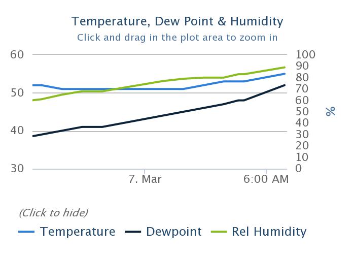
Instead of our normal diurnal pattern, temperatures have risen across the area since midnight for Houston, generally from the lower 50s to the upper 50s. This is indicative of the much warmer airmass that has begun moving into the area, and which may lead to some potentially unsettled weather over the next few days, especially on Saturday. Unfortunately, the weekend weather doesn’t look exactly ace, although Sunday has some potential.
Thursday
Today will be a gray affair, with intermittent drizzle, especially closer to the coast. Some light rain showers will be possible, but for the most part any rain today will be misty. Dewpoints will continue to rise today, leading to much higher humidity, as temperatures rise up to around 70 degrees today. Low temperatures tonight will not fall much, probably only into the mid-60s.
Rodeo weather
 Temperatures will be in the upper 60s at the Houston Livestock Show and Rodeo this evening, with cloudy skies, and light winds. There’s about a 40 percent chance of a light, misty rain, which likely will end before the show ends. Temperatures after the concert will be about the same, as will the 100 percent cloud cover.
Friday
Friday should be similar to Thursday, although 5-7 degrees warmer, and with a healthy chance of morning fog as warmer air moves over cooler waters. Highs will be in the upper 70s, with more light rain showers. Again, accumulations should, at most, be measured in a tenth or two of an inch of rainfall.

Saturday
A weakening cold front will near the area on Saturday, when the region could see some storms. To create thunderstorms we need several ingredients in the atmosphere to line up, including lift, moisture, and instability that provides energy for storms. All of those will be around on Saturday, but they may not align in terms of timing for Houston, and a better chance of doing so lies to the northeast of our region.
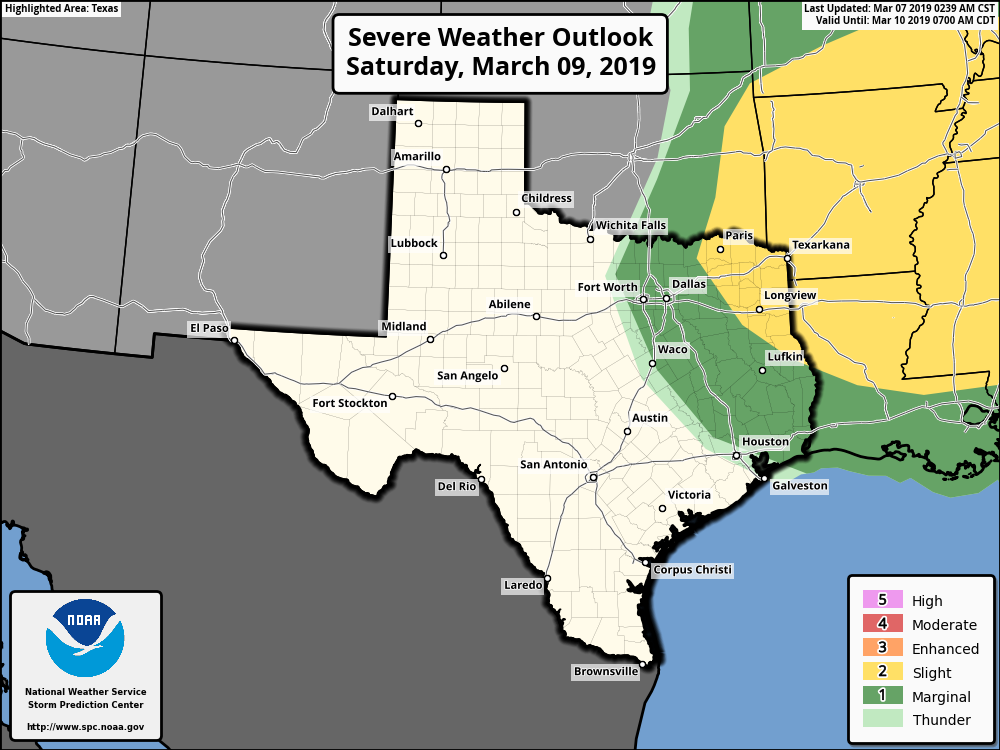
Houston, therefore, is on the periphery of severe weather potential. For the most part, then, Saturday should be warm, in the 70s, and gray, with on-and-off mostly light rain. Accumulations don’t look significant unless thunderstorms develop further to the south than anticipated. Rain chances drop off fairly quickly on Saturday afternoon or evening, after the weak front moves through. Skies should also clear overnight, but temperatures probably won’t fall much below 60.
Sunday
This should be a bit of a decent day, although the sunshine we were hoping for probably isn’t going to last all that long—mostly during the morning hours. So despite springing forward on Sunday morning, if you want to see the sun, you’d probably better get up early. There will be some slight rain chances later in the day as well, with highs in the 70s.
Spring Break outlook
Next week could be a week of two halves. The first part, through Wednesday or so, appears to be fairly warm, with highs in the upper 70s, warm nights, and mostly light rain chances. Sunshine will be fairly scarce. At some point (Wednesday night, maybe?) a stronger front will roll through, and bring plenty of sun to the area, but also drive daily highs down into the 50s or 60s, with nights in the 40s. This cooler pattern appears more likely than not to hold through the remainder of Spring Break and the weekend.
When you say “To create thunderstorms we need several ingredients in the atmosphere to line up, including lift, moisture, and instability that provides energy for storms“ what exactly do you really mean by the term “instability”? I understand the first two items lift and moisture but how does one measure this rather nebulous term “instability”?
Nebulous is relative.
For example:
https://www.weather.gov/source/zhu/ZHU_Training_Page/thunderstorm_stuff/Thunderstorms/thunderstorms.htm and https://www.weather.gov/media/zhu/ZHU_Training_Page/clouds/stability_clouds/stability_clouds.pdf
If you guys don’t start predicting better weather I am going to have to unsubscribe.
Agreed! LOL
Lol. It’s been a copy and paste type of winter forecast. I’m so over it. The only way to get sun is for it to be cold and windy. The only way to get warm weather is for it to rain the entire time. I have sat on my back porch since probably September. 🤣🤷♂️😞
Welcome back to Seattle! Although I’ll take their “aUGHust” weather anytime. That’s when the locals complain about “hot when it’s 85,”
Are y’all no longer going to be posting to Instagram?
We are supposed to do the regatta on buffalo bayou Saturday 7am-11am. I am thinking the weather might not cooperate 🙁
I want to dona little bit of planting. Do you think we’ve seen our last hard, extended freeze for the year?
I do. I’m not 100 percent there yet, but we’re close.
Is the front coming on Saturday expected to stall?
Why are we getting only mist or very light drizzle for a few minutes instead if real rain?? It has been like this at our house (near Humble) for many weeks now. We are dry below the surface. We really need an inch or 2 not .01 or .1″. What has changed?
Eric – any idea when this cloudy/rainy pattern will end?
I had hoped Feb would be the last of it, but here we are the 7th of March, and there doesn’t appear to be an end in sight.
I know it’s been cloudy, but we really haven’t had so much rain and storms as I would expect in an El Nino year (that is, since December ended). The Weather Channel says that only Texas and a few other southern states had significantly below average precip in February. Is it just not a very strong El Nino?