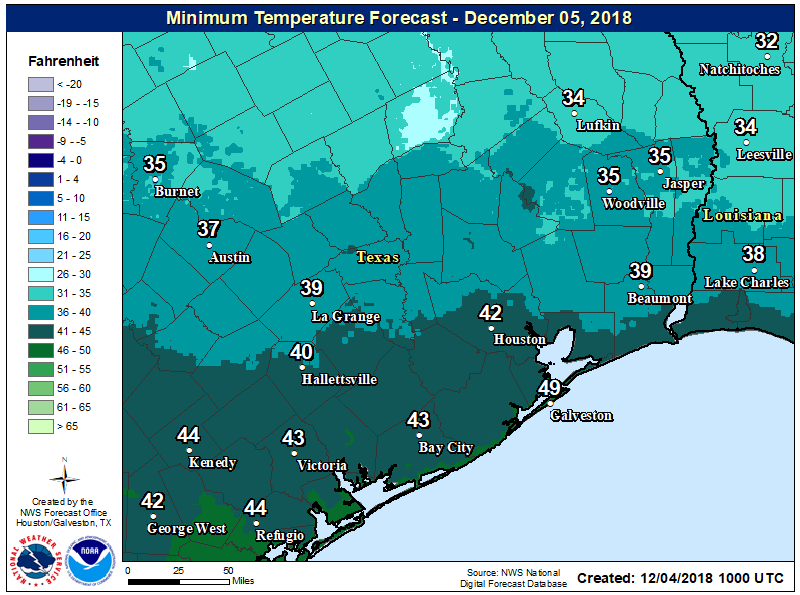
It’s a chilly morning across the region, with lows ranging from 35 degrees in Huntsville to around 50 along the coast. As high pressure dominates our weather, conditions will remain quiet until later this week, when a storm system will combine with ample Gulf of Mexico moisture to produce widespread showers and thunderstorms across the region. Some street flooding appears possible Friday night, but fortunately the system won’t linger as a strong front scours the region on Saturday morning.
Tuesday
Cool today, with a northerly flow. Despite sunny skies, highs probably will only get up to around 60 degrees. Nighttime temperatures will be similar to Monday night.
Wednesday
Northerly winds will shift to the east, but that won’t mean much during the daytime, as we can expect another sunny day with highs of around 60 degrees. The more easterly winds should help to moderate overnight temperatures, however, with lows by Thursday morning generally in the upper 40s and 50s.
Thursday
Winds continue their rotation, and will come out of the southeast on Thursday, and this should lead to a mostly cloudy day with highs in the upper 60s to around 70 degrees. Rain chances are quite low, but not non-existent.

Friday through Saturday morning
The onshore winds that kick in Wednesday night will pile moisture into the atmosphere. Meanwhile, a potent low pressure system will sweep eastward, across Mexico and the Southern United States toward Texas. This system should promote rising air, and lead to a very healthy chance of showers and thunderstorms, especially on Friday night into Saturday morning. (Temperature wise, we’ll probably remain in the 60s throughout this period).
In terms of timing, right now the forecast models generally peg the heaviest rain west of Houston around midnight, and pushing through the city between midnight Friday and sunrise on Saturday. The storms move east by mid- to late-morning as a strong front sweeps through.
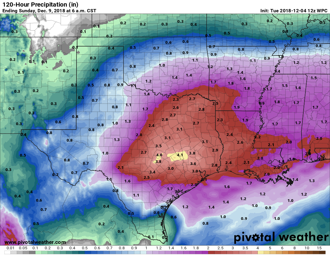
As for accumulations, I think most areas can probably expect 2 to 4 inches of rainfall, but given the moisture levels available I’m pretty sure we’ll see some bullseyes of 6 inches or more on Friday night. Where this occurs in the greater Houston area simply cannot be predicted, but some street flooding is sure to occur during these heavier storms.
Saturday afternoon through Sunday, and beyond
Saturday should remain a mostly cloudy affair after the front moves through, with temperatures falling into the 50s. Nighttime lows probably will be in the 40s. Sunday will likely be a sunny, cold day, in the 50s, with a northerly wind. Temperatures will moderate some by Tuesday or Wednesday, and rain should stay away until Thursday or Friday, at the earliest.
Excellent, no 70’s just yet! Yesterday’s forecast had me a bit nervous. As long as the 25th isn’t 80 degrees like a few years ago. We prefer the snow!
More like 84 and humid that “Christmas”.
sigh … ice is for drinks, not ground cover. If I wanted that, I would’ve stayed in Chicago. Bring back the warm air!
Eric/Matt – We are leaving Galveston Thursday afternoon on a 4-day cruise to Cozumel, with sea days on Friday and Sunday. Any idea of what kind of temperatures or rain we might be looking at in the Gulf on those sea days?
As always, thanks for all you do.
Rains will be in the northern Gulf on Saturday/Sunday, but they can probably be avoided by the ship. Temperatures should be in the low 70s regardless. Enjoy!
Since weather is not an exact science and rather is art, I’m grateful for your sense of artistic neutrality when it comes to colors you use to paint a portrait of the weather..Great Work from true artists.
At least he isn’t having to add new colors to show the rain amounts like last fall……
What a lovely comment Robert. They truly do paint a honest portrait of the weather. Bravo!
Haha, thank you Robert!
Thank you so much for your very accurate, yet unemotional, approach to weather forecasting, which we all know is an ‘art’ and not an exact science. and you paint with very neutral colors…A friend who lives in Beaumont simply looks out the day every day, and if it looks good to him, he goes ahead and gets dressed and proceeds with his days activities. When he sees inclimate weather, he simply makes another cup of coffee and goes back to bed …..
What’s in your coffee robert?
Any ideas on the coldest we can expect this winter?
Since Friday is not Christmas, or any other holiday, I doubt it will flood.
If the GFS model has us at 10” at 84 hour, how is everyone (local news, NOAA, etc) coming up with 2-5”????
Because to believe a total like that, we need to see some run-to-run consistency.