Good morning, Houston. The radar is quiet as the sun begins to rise, but it’s not expected to remain so. We still anticipate a pair of rainy, but not menacing days, before we finally move beyond the persistent threat of rain on Sunday. The Atlantic tropics are also starting to heat up, but again, we don’t see any really significant threat from this. More on the tropics below.
Friday
I’ve had so many questions from readers about the weather for this Friday and Saturday that I know many of you have outdoor activities planned for this weekend. So for those of you with birthday celebrations, graduations, and weddings, I am sorry. The news is not great. It’s gonna rain.
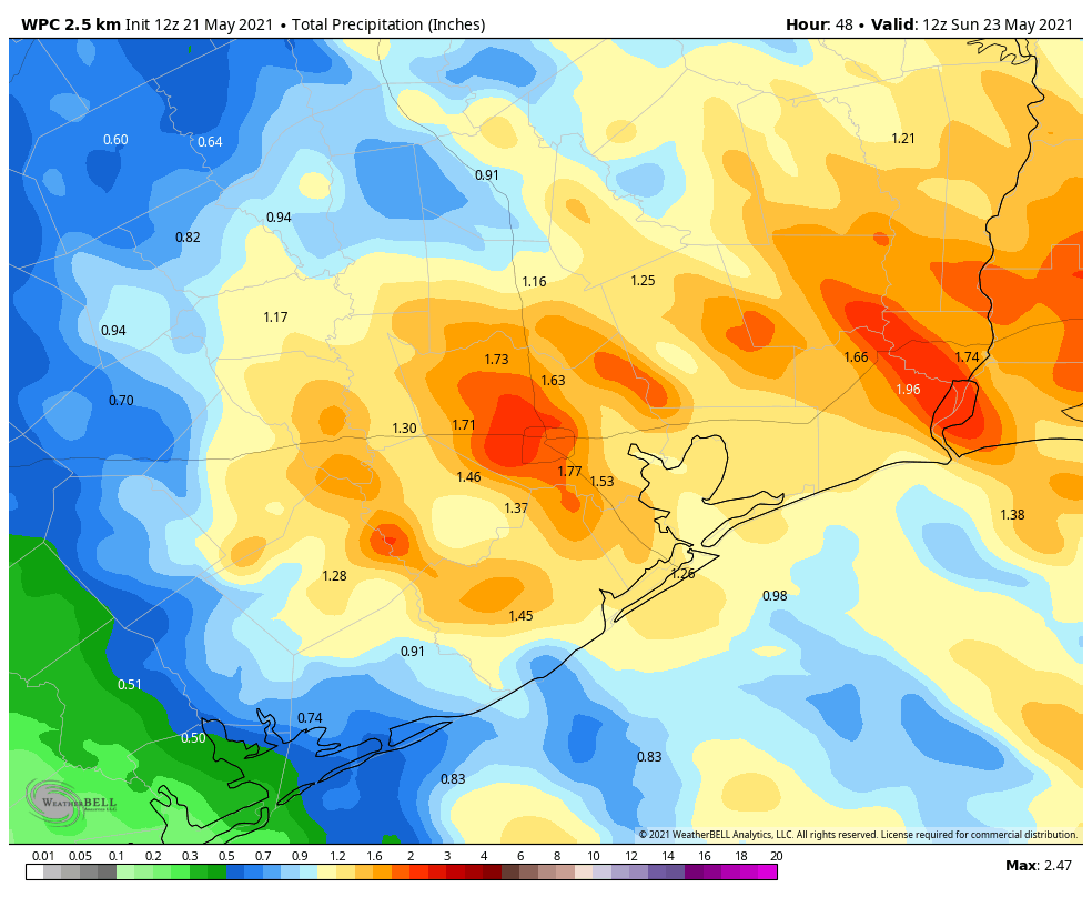
Showers should remain rather scattered this morning, before becoming more widespread this afternoon. We may also see a few stronger thunderstorms that produce some briefly heavy rain. However, these showers should scoot through the area, from southeast to northwest, at a pretty good clip, helping to limit accumulations. Totals for most people today should be on the order of 0.5 inch, with some areas seeing more, some less. Highs today will reach about 80 degrees, with plenty of humidity, and skies will of course be mostly cloudy. Rain chances back off during the evening and overnight hours, with lows only dropping to around 70 degrees.
Saturday
We’re not sure when the bulk of the precipitation is going to come on Saturday, whether its largely during the overnight hours into the morning, or whether it’s more of a midday or afternoon thing. What we can generally say is that most areas will probably see about 1 inch of rain, give or take, and the better chances for heavier rainfall will lie west of Interstate 45. The bottom line is that while this rain will put a damper on outdoor activities during the daytime, I think things should begin to clear out during the evening and overnight hours. Highs will again be around 80 degrees.
Sunday
We can’t rule out some light showers again on Sunday, but I think these will primarily occur west of Interstate 45 and should be fleeting. Skies will start out cloudy, but we may see a few flecks of sunshine before the day ends. Highs will again reach about 80 degrees.
Next week
Rain chances won’t be zero next week, but they’ll be in the 20 percent range for most days, with overall very low accumulations. Highs will climb into the mid, and probably upper 80s as skies turn from partly to mostly sunny by mid-week. We might reach the 90s by next weekend.
Tropics
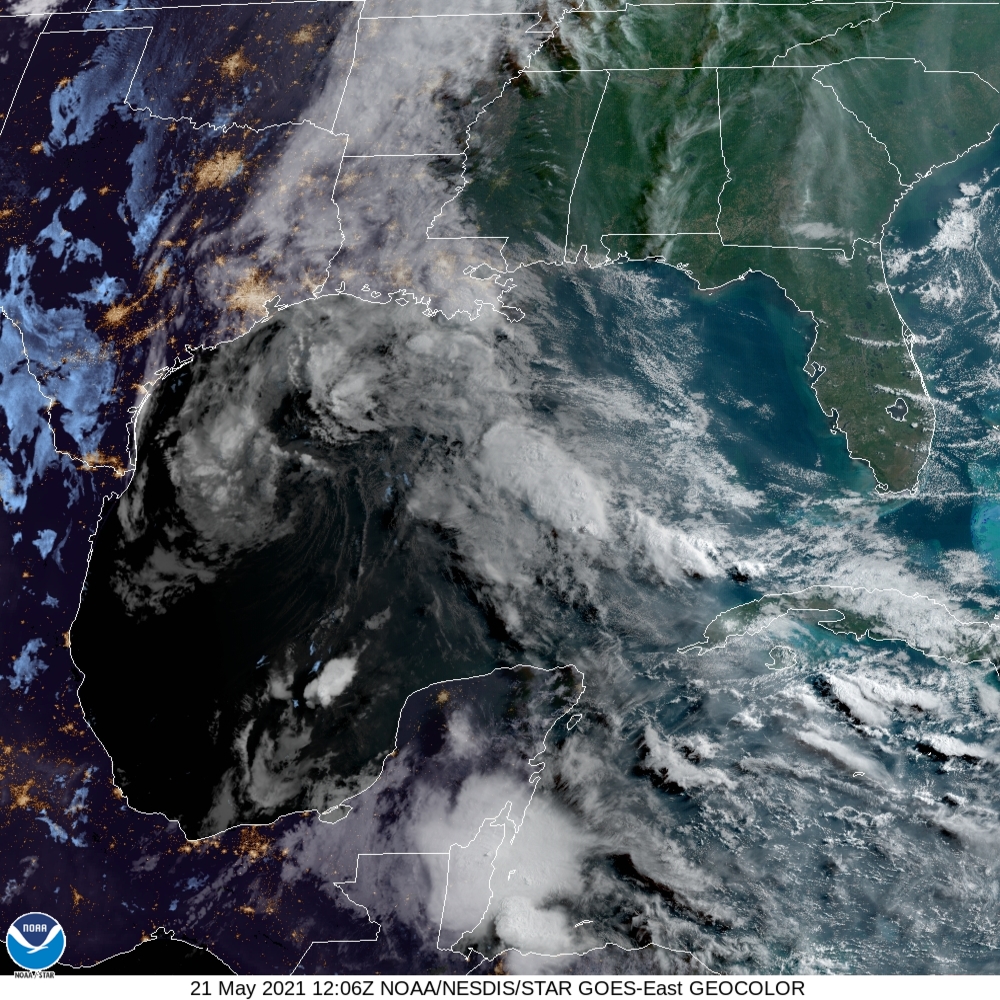
So what’s going on in the tropics? I want to talk about three things. First of all, not much has changed with the Gulf of Mexico disturbance overnight. It’s still there, it’s still disorganized, but it still has a narrow window to develop into a tropical depression as it moves toward the Texas coast. The National Hurricane Center gives the system a 40 percent chance of becoming a depression before moving into Texas tonight. Even so, we don’t think it will change our forecast much. If that changes, we will of course update later today.
Another system in the open Atlantic is more likely to become a subtropical storm over the next day or two. This one won’t affect land, but would gain the name “Ana,” and become the Atlantic season’s first named storm even though the season doesn’t begin until June 1. A weak storm forming before the official beginning of hurricane season happens fairly regularly, so it’s nothing to get alarmed about.
Finally, NOAA released its Atlantic hurricane outlook on Thursday, and it calls for an “above normal” hurricane season, with 13 to 20 named storms. This is in line with other season predictions, and I just want to reiterate what we wrote in April about all of this.
Seasonal hurricane forecasts are far from perfect. I think, generally, we can expect a busier Atlantic season, but we’re almost certainly not going to see a brute of a year like 2020. Moreover, the chance of the Houston area being directly affected by serious tropical weather (in terms of floods, winds, or surge) is pretty low. Historically, the region only sees a significant storm about once a decade or so. Therefore, while it certainly is time to begin planning for the 2021 Atlantic season, I very much do not want you to start worrying or obsessing about it. Matt and I will, of course, be here every step of the way.
We’ll be back with another post this evening, or Saturday morning, to wrap up the Gulf disturbance situation, and our expectations for rainfall on Sunday.
Thank God for you. That is all.
Thank you so much for your knowledge and expertise, especially as we begin the hurricane season. You can calm me down tremendously with just a few sentences! I was awake when Eric wrote his report around midnight during Tuesday night’s storms and boy, did I let out a huge sigh of relief! He spoke the truth and that’s huge during a time when I’m downstairs in my “safe spot” with two anxious dogs because of the thunder and lightning. “Was that a tornado? It sounded like a tornado. Check Space City Weather”. And there was Eric’s report saying that the storms were moving quickly through town. Appreciate all of you!
Your calm, informed reporting complete with reassurances and expertise is a Godsend. Thanks for all you do.
Eric, hoping for an app announcement soon. I’ll pay if needed. Thank you both for your help.
Why? What do ya’ll think an app is going to do that the website don’t?
Howdy! I suppose it depends on what the app contains. But even if there is nothing more than push notifications on when they put out another post, discussion, or warning that would be greatly helpful by itself. Personally I am hoping to replace my other phone app since I read their posts daily and really only use the app for alerts and radar.
I agree, what’s the problem looking at a browser on your phone?
Can’t wait for the app!
So, is the tropical system in the gulf related to the “model storm” which showed up last week in the American model, I believe? Seems a pretty big coincidence…
It is very hard to predict rain during the spring time, from April through June Houston tends to be rainy and showers can pop up in some areas and not others. Really, into the summer there used to be frequent rain storms around mid or late afternoon, that would last about ten minutes and then the sun comes out and it gets very humid.
This persistent rain has caused havoc for my plants and lawn, can’t cut the grass it’s too wet and muddy. Branches and leaves have fallen everywhere. Cactus plants don’t want to stay wet for days.
This year has been cooler than most. I have not turned on AC yet this year.
It’s funny to me that these two guys have somehow been positioned as the weather therapists of Houstonians that experience chronic anxiety about the weather due to trauma or general nervousness. Their “non-panic” approach led them to completely whiff on the impact Imelda had. They also weren’t really on the cutting edge of information when it came to just how disastrous Harvey was. I could go on and on about how they are really just like every other meteorologist, but have learned that the “stay calm” approach to marketing is appealing to people that are always (rightly) worried about what living along the coast in the Gulf of Mexico means for everyday life.
What’s funny is, given your opinion of these two guys, that you read the blog and leave a comment.
I think the fact that they take the time to explain, in detail, what we might expect. They also try to include all scenarios and own it when they get it wrong. Some of us need more than an hourly percentage and short blurb about the entire Gulf Coast. It definitely gives me a peace of mind just being informed!
I to think they coddle the readers a bit, perhaps rightly so, but go back and read the entire archive for Harvey. The event was an unprecedented meteorologic event. At least for our area. Bangladesh comes to mind. Hindsight is 20-20.
If nothing else the TV forecasters have toned down their rhetoric since this blog came out. The folks that write the boiler plates…not so much.
I will go back and look at their Imelda coverage.
I think that most everyone missed on the Imelda forecast and the impact that it had.
Oh, come on. They’re meteorologists, not wizards. Weather in Texas is unpredictable, and there’s a limit to what any forecaster can do. SCW has always done a great job of laying out the risks of a given system in as straightforward a manner as possible. They also do a great job of owning it when they aren’t sure about something or when they end up being wrong about a forecast. I appreciate the fact that they explain the science behind their forecasting and show us models and maps to help us understand how they arrive at their forecasts. Far from coddling their readers, they treat us like rational adults who can understand science and draw intelligent conclusions from data. Some of us, unfortunately, are not rational adults.
The Weather Channel pegged Harvey best of all…in hindsight they were most accurate.
These two are better at explaining WX than most, and they respect the readers when they do, which is appreciated; however their accuracy is not better than most other local sources…Or national sources like NOAA or WX Channel.
The exception is Accuweather, they are horrible. It is mind-boggling how they get away with what they do, but that is for another blog I guess.
I say this having studied meteorology knowing it is art and science and as a licensed pilot having flown through some it. You may disagree, of course.
I will keep reading here as well as checking other sources and appreciate the site overall.
We’ve seen their accuracy be unparalleled, especially at the end of the hurricane season last year when there were 3-4 late depressions/hurricanes in about 4-5 weeks. Everyone else said they were going to make landfall in Houston, but Matt and Eric watched them constantly and disagreed with the others, saying they would veer east and not hit directly in Houston. We watched along with them, and felt they were right. Despite a mandatory evacuation order for Tiki Island, we tied down our furniture and kitty cats and did not evacuate and had minimal rain and no flooding. The same happened for the subsequent storms.
I like TWC for the personalities and entertainment, but they get so bored when there isn’t anything big to cover that they start hyping flying leaves stuck to screen doors and wading through puddles and have bee caught exaggerating things on camera. When we say “no hype,” that’s what we mean and like. As others have mentioned, they are honest when they are unsure of a prediction and don’t hesitate to say when they missed a call. They know their limits, but to us, they are the most knowledgeable and humble about their abilities in trying to help and educate us that are not experts in the field.
I know there was a typo, Joni, but I about lost it at the mental image of you tying down your kitties. Thanks for the giggle.