It’s another cool morning across the region, with highs generally ranging from the 50s up north to the lower 60s along the coast. It is hard to believe we reached 91 degrees only on Sunday, but fall truly has come. Some inland parts of the region may not hit 80 degrees for the rest of this month, although after today we’ll see a moderate warming trend for a few days. If you’re tired of the gray weather, Sunday is your best hope.
Wednesday
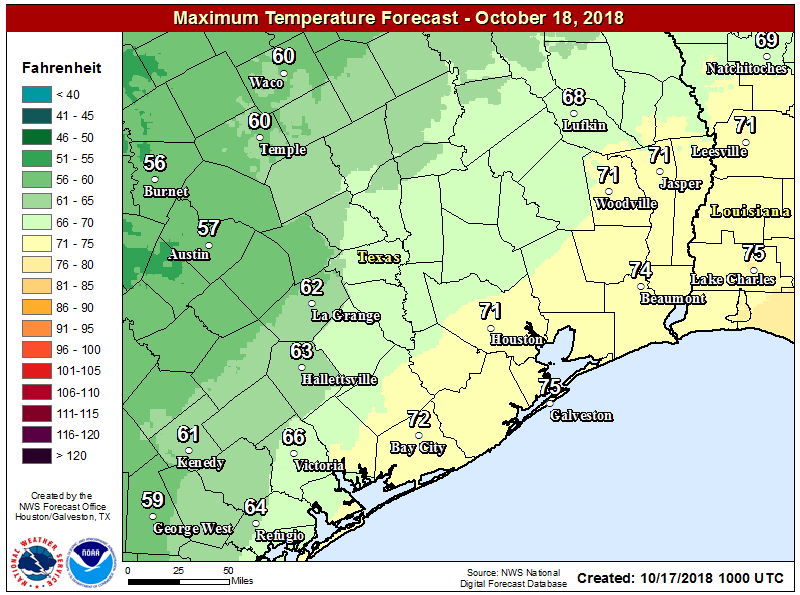
Today will probably be similar to Tuesday, with mostly to completely cloudy skies, highs only around 60 degrees for northern areas, and mid-60s for the city. For better rain chances, we’ll need to look to areas far north of the city (i.e. north of College Station or Huntsville) and along the coast and offshore. Chances in Houston will probably be in the 20 to 30 percent range, with what does fall coming down mostly as light mist or drizzle. So basically, another gray day.
Thursday and Friday
Mostly cloudy skies continue, under a northeasterly flow. There’s plenty of moisture toward the second half of the week for the atmosphere to work with, so we’ll probably see more widespread light to moderate rain for Thursday and Friday.
Accumulations, for the most part, should be measured in tenths. Highs should manage to make it into the low 70s, which is still about 10 degrees below normal levels for this time of year.

Saturday
It looks like the region’s next moderately strong cold front will push through on Saturday. Unstable air ahead of, and along with this front should provide a bump in rain chances to around 50 percent on Friday night and Saturday. Overall, most areas probably won’t see more than a quarter of an inch, or so, but I think there’s definitely the potential for some localized heavy showers where thunderstorms pulse up. If you’re planning to be outdoors on Saturday, this is something to be aware of. Highs Saturday should be in the low 70s for much of the city, but warmer along the coast.

Sunday
With the front’s passage, Sunday’s forecast looks somewhat better. With drier air, the high of around 70 degrees on Sunday should feel mighty fine, and by the late morning or afternoon, skies could be partly to mostly clear. It’s not a guarantee, but as of now Sunday looks to be one of the finest weekend days we’ve had in a long time. Fingers crossed. Lows Sunday night should drop into the 50s for everywhere but the coast.
Next week
The forecast for next week is not exactly clear—some models bring another front in by Wednesday or so, others have a warming trend through much of the week. So for now, who knows.
Not dreary..this is great weathet.
I’m with Keith. This is blissful. I don’t want it to ever end.
I don’t care about dreary. I care about it not being 90 stinkin’ degress and 100% humidity every day.
I haven’t seen any of you outside this week.
Agreed, I’d be OK with this for a while, with just a little bit more sun thrown in every now and then…
When I lived near Seattle I came to understand that there exist people who prefer dark and moist.
What is the timing for the front on Sat? Any chance for clear skies after it passes through during the day on Sat?
I’m cool with the clouds for a while. I’ve seen enough of the sun. I know what it looks like. I’d be happy if this was our fall, but I realize we are “cooler than average” and that the 80s are just around the corner.
Eric, 2 questions: 1) why does WPC have heavy rain for us from 10/19-10/23?
2) any chance you can start addressing hydrology? SJRA started releasing water from Lake Conroe (in the middle of the night again), because the watersheds received 6-7 inches of rain. Interestingly enough, others I’ve talked to had no idea that much rain had fallen or was predicted to fall. Needless to say, this then causes flooding downstream, yet we haven’t been made aware that flooding was even a potential with the current weather conditions!
Thanks for your consideration.
Can you speak to the weather pattern causing so much rain and flooding in the hill country?
Heading to “Wings Over Houston” on Saturday. Any ideas about the timing of the front yet?
Heavy tunderstorms precisely 13 minutes before the Blue Angles appear.
Seriously, we’ve been blessed by “severe clear” most of the last couple of years so I wouldn’t complain about some clouds this year.
I’ve lived in houston 15 years and this is the coolest october i can remember
What’s the likely impact on that additional rain forecast on flooding in central Texas?
ANY chance the next cold front arrives early and clears things out for Saturday evening? We have Pee Wee Bowen, John Michael Montgomery, and Clay Walker at our big outdoor festival in La Marque Saturday and the concerts begin around 4 PM. Can we have some good vibes for an early cold front passage? Thanks friends!!
I love this weather!! I’m originally from Seattle😉
What’s up with the weather app on my iPhone saying “very unhealthy air quality” right now?! I have never seen that message before!