We got an update from the U.S. Drought Monitor yesterday that would factor in the bulk of the rain we received in our recent scattershot rounds of liquid gold last week. Suffice to say, it did not do much to alleviate the ongoing drought.
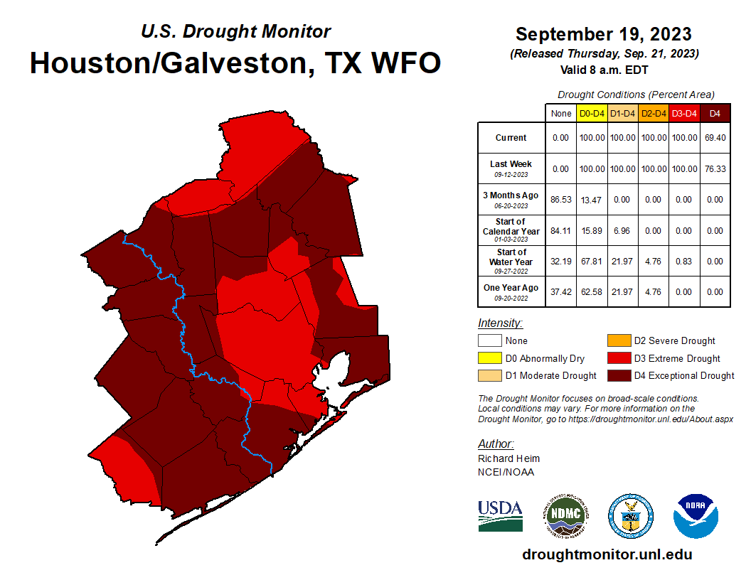
Keep in mind, the way these maps are calculated does not always adequately represent the current soil or dryness or greenness of your grass situation. The drought maps focus more on longer term issues related to drought. Those don’t disappear overnight. If we can get some more rain later this weekend or Monday, that will go a short way to helping things a little.
“So, shut up, Matt, and tell me if we will see rain!”
Today & Saturday
First, the heat. The 97° officially reached at IAH Airport on Thursday ties for the 7th latest date we’ve recorded that high of a temperature. The latest? October 2, 1938. That’s not a record I feel like breaking. Unfortunately, it will not get much better today or tomorrow. Look for highs in the mid to upper-90s in the area. Someone might hit 100°, which is just a <chef’s kiss> on this summer. Mornings will be warm and humid, with mid-70s. Equinox? More like Weakquinox.
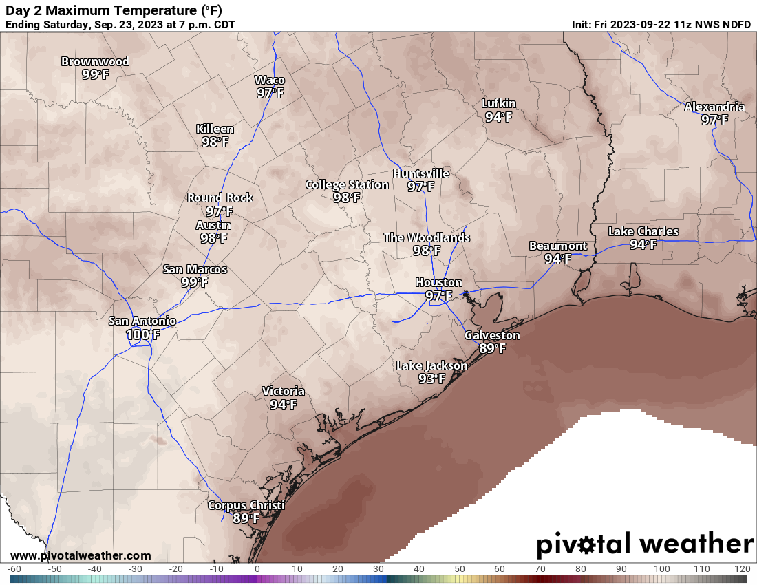
Rain chances look meager both today and tomorrow, but they are not zero. Hopefully a few spots can squeeze out a cooling downpour.
Sunday
More of the same as Friday and Saturday. Rain chances may be a bit higher in the northern reaches of the Houston region, especially late in the day. But still I would say, at best, isolated to scattered activity.
Monday
So, let’s try to get excited about Monday. That is, if you want rain. We continue to see signs that a cold front will cross into our area, acting as a focal point for scattered to numerous showers and thunderstorms Monday afternoon. Let’s set some boundaries here. I do not believe that everyone will get meaningful rain from this, however I do believe most people will get at least some rain.
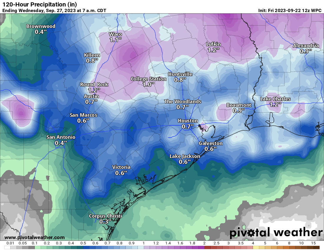
Great news, for sure. Let’s just hope it actually happens as planned. Monday’s temperatures should be warm to start (mid to upper-70s), but the daytime should not be as hot as Friday through Sunday. Look for low-90s before the storms start popping up. Areas south and west of Houston, furthest from the front will probably do mid-90s again. You do need to watch these fronts sometimes because the compressional heating that occur just out ahead of them can sometimes lead to hotter than expected weather. So folks in Brazoria or Fort Bend Counties southward could see another pretty darn hot one Monday before storms (hopefully) roll in.
Tuesday and beyond
The biggest question surrounding next week’s forecast is how far south the front gets before it runs out of gas. If it can push offshore enough and dissolve out there, we likely see some pleasant mornings (low-70s) and lower humidity with highs in the upper-80s to low-90s. But it would also be fairly dry. If the front breaks up at the coast or just inland, we’d still see some cooler temperatures and lower humidity, but not as much as we saw earlier this week. But we’d also keep slight rain chances around most days. So, pick your poison I guess. We’ll watch the forecast through the weekend and see how it evolves.
As for the first true fall front? I’m not yet optimistic or ready to commit to anything, but I do see signs in the October 6 to 10 period that perhaps something could begin to stir. At the least, it’s the most hopeful signal I’ve seen this month, so that’s worth something. Stay tuned.
Tropics
Potential Tropical Cyclone 16 will bear down on the East Coast this weekend with tropical storm conditions, tidal flooding, and heavy rain expected from the Carolinas through New Jersey or Long Island. A system in the deep Atlantic may pass just north of the islands next week. For us? The Gulf looks very, very quiet. Be sure to visit our companion site, The Eyewall for a full rundown on tropical doings.


Honestly guys, even though we had a hell of an August that BEAT the former trophy holder of 2011, we had quite the number of weak front days with drier air (Aug 16, Aug 30) why are we even surprised Fall Day is late this year?
Fall Day is late because it’s getting hotter here. It’s been in the mid 90s all month and may hit 99° today. This is the hottest September I can remember, I’ve been here 33 years.
According to my facebook memories this morning, the Weakquinox last year hit 104 on my car thermometer. So I’m taking this as a “could be worse” type situation.
But it also got down to 59 on Sept 27&28, and down to 55 on the 30th. What a dream!
Weakquinox lmao!!
“Equinox? More like Weakquinox.”
Booooo
🙂
Really appreciate Matt’s look beyond 7 days (October 6 to10). A lot of us are dialing up the GFS to try to do this – for hope on breaking the heat and dry. But always good to have an expert providing some verification.
Except he is not guaranteeing cooler weather, just to stay tuned for now. Don’t get your hopes up just yet DJ
I want a bloody tropical storm and I want it now!
Thats a horrible thing to say Ken, shame on you
Huh ??
A tenth of an inch of rain cannot be expected to break any drought.
The hottest temperature on record for October is 99 on October 1st 1900. It would not suprise me if we end up having our 1st 100 degree day in October history the way this summer has been.
I think Houston had a 100° Fahrenheit high temperature on October 13th on some year.
Lived her all of my 63 years and one thing is consistent…summers die a long, slow, miserable death in Houston.
Fortunately most of us have air conditioning, but there are many in this city that are not so fortunate.
I’m so ready for this heat to go away. This has been an obnoxious summer to say the least. Think I’m about ready to pack up and head to cooler pastures next spring.
You snow bird, you…..
1!:~D}